3. Development Plan Contents
Introduction to the Development Plan
The Development Plan Contains Proposals, five Land Use Policies and a Proposal Map on Housing, Local Green Space and Employment.
Under the Localism Act 2011, the Policies WDP 01 to WDP 05 form the 'Plan's Policies'. They are intended to form part of the Statutory Planning Framework.
The Development Plan Proposals and Land Use Policies were arrived at through testing Options against the Sustainability Criteria and Public Opinion. A detailed analysis is available in the Annex, Pages 13 to 44. The Development Plan is informed by the Area Portrait & supports the Vision for the Area as expressed in the Community Objectives. The Development Plan should be read together with the Area Portrait and the Annex.
Proposals & Policies
Housing
Policy Background
The DDC Core Strategy Policy CP1 classified Worth as a Village, suitable for a scale of development that would reinforce its role as a provider of services to essentially its home community. Policy CP 3, seeks to identify sites for 1200 houses in the Rural Area. It doesn't assign housing numbers to individual rural communities, but a pro rata share, equates to the high 20's for the Worth Neighbourhood Area. The National Planning Policy Framework encourages Neighbourhood Plans to set out planning policies to determine decisions on planning applications. They can't promote less development than that set out in the Local Plan (DDC Core Strategy).
Non Strategic Policy DM 1 of the Core Strategy proposes settlement boundaries for planning purposes and sets out the principle that development, with some exceptions, will not be permitted outside the Settlement Confines.
Housing Need
Lack of housing is one of the main reasons people leave the area (Ref 26). An affordable housing survey (Annex, Page 14) indicated local demand for eight new affordable houses.
A Kent County Council Research and Intelligence study (Ref ED 7) carried out for Dover District Council predicted that maintaining a stable population in the rural area until 2031 required an increase in housing stock of 9.3%. This equates to around 30 new dwellings in the Worth Neighbourhood Area
In considering the need for affordable housing, maintenance of a stable population, compliance with the Core Strategy and factoring in the vision for the area, in particular Community Objective 1 - Housing, the Development Plan seeks to provide at least 30 new, predominantly family sized homes, during the period to 2026.
Housing Site Options
The available housing sites (Annex, Page 14) could meet the identified need for 30 houses many times over and each potential site was tested against Public Opinion and the Sustainability Checklist, (Annex Pages 14-31)
Of the options, (Annex, Page 23) the Bisley Nursery site (D8/9) performed best against both Public Opinion and in the Sustainability Assessment. The site D8/9 was supported by 57% of households and could, on its own, meet the areas housing requirements. It scored higher than any other site against most of the individual Sustainability Checklist Criteria.
Like most other potential sites it is outside a flood risk area and like other sites with a central location it was judged to have little potential impact on the need to travel. Because development would involve demolition of existing structures and their replacement with Open Space and planting of native species, the site scores better than any other on Health and Well Being, and Biodiversity.
The demolition of the house Bisley and creation of an open frontage has the potential to improve the setting of Worth's Heritage Assets while promoting locally distinctive design. As a result the site scores higher than any other against Built Environment and only one other site, (a brownfield site D5, Annex Page 21) equals its score against Environmental Accessibility.
Finally, while enhancing the Local Environment, the Bisley Site provides the opportunity to address many Community Objectives and it scores higher than any other site against Service Accessibility and Development Benefits. Its combined score against all eleven Sustainability Criteria is +19; the next highest scoring sites D13, D7, D5 & D12 (Annex , Pages 27, 22, 21 & 26) score respectively + 2, +1, 0, & 0.
Housing Opportunities
The development of the Bisley Nursery site offers the opportunities listed below. The Development Proposals (page 36), and Policy WDP 01 (page 39) are designed to realise these.
- meet the recognised housing needs on one site in an area close to the village centre and its facilities
- provide sufficient affordable housing to meet local need (Community Objective 1)
- allow the creation of a Village Green, opening in a wide entrance directly onto The Street, helping to incorporate the Village Green and the new housing into the existing village while enhancing the immediate surroundings
- allow development that respects the built form of Worth, improving the setting of the Conservation Area, listed buildings and buildings on the List of Local Heritage Assets
- provide an additional Open Space and recreation area which could double as a football 'kick about' area (Community Objective 8)
- provide additional car parking directly opposite the Village Hall (Community Objective 4) and land for a new Village Hall if it is ever required
- allow for additional boundary planting reducing landscape impact while opening up vistas, of the rural hinterland (Community Plan Objective 13)
- benefit the near neighbours by improving the local landscape surroundings of The Street.
The Bisley Nursery Site
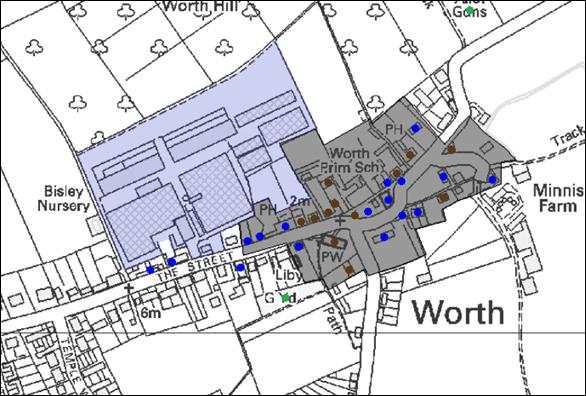
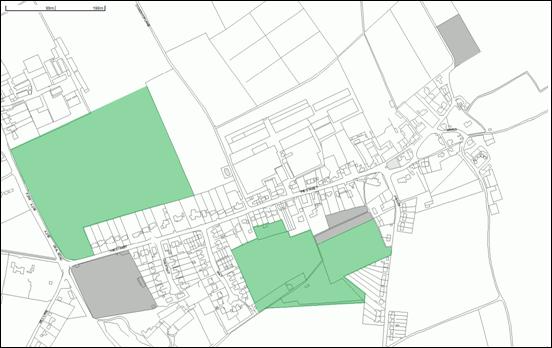
Figure 5 shows the location of the Bisley Nursery Site and its relationship with the Neighbourhood Areas Heritage Assets. A full description of the site is available in the Annex , Page 31.
Development Proposals
Development of the Bisley Nursery site is proposed in three parts: Area A, Housing; Area B, Open Space and Area C, Agriculture. As a guide these areas are shown in Diagram 1 on Page 38.
- Housing development covering no more than 1.9 hectares is proposed. Development in this location offers the opportunity to reflect the clustered nature of the built environment, while respecting its rural character; providing family and affordable homes to address the imbalance in demographics. Development should be guided by its location on the edge of the countryside, reflecting and enhancing the existing grain, local character and housing density. The impact of development on the neighbouring Heritage Assets, including the Conservation Area, should also be a consideration in design.
- In respecting the existing Built Environment (Pages 12-14 & Annex Page 13 & 14) housing density should be around 14 dwellings per hectare. The development should provide approximately 30 (gross) new dwellings in total. This number of houses is consistent with the Development Plan goal. It recognises this number may be required to make the site viable, while providing the associated community benefits. The housing density is below that required in the DDC Core Strategy Policy CP 4, but is supported by National Planning Policy which encourages Neighbourhood Plans to respond to local character and history and to reflect the identity of local surroundings. A supporting Sustainability Appraisal of housing density is available in the Annex, Page 13. The single vehicular access point would be onto The Street. In line with Highways requirements a footway should be provided on The Street as part of the junction improvements. To ensure connectivity, proposals should provide links to the two public footpaths on the western and northern boundaries.
- The impact of the housing development on the wider landscape will need consideration. To ensure the impact is mitigated, additional planting to strengthen the northern, eastern and western boundaries will be required. Development (including gardens) should be a sufficient distance away from these boundaries (e.g. 5 metres) to ensure that there is no pressure to remove the tree/hedgerow cover at a later date. Maintenance of this buffer should be a condition of Planning Permission.
- A local requirement for affordable housing has been identified and this should consist of 9 housing units, equating to 30% of the development. For practical reasons, the affordable housing should be located within a single location. Ownership of the affordable housing land will be transferred to Worth Parish Council and the affordable housing will be transferred, at a pre-agreed cost, to a housing association e.g. English Rural. The Housing Association will rent the land from the Parish Council. It is the intention of the Parish Council that the affordable housing should be for local people (within the Neighbourhood Area) and the Housing Association will follow a sequential approach to allocate the housing. In the event that local demand proves insufficient, residents from the neighbouring rural Parishes of Woodnesborough, Northbourne & then Eastry will be considered.
- The site contains an existing residential property (Bisley). It is important that this property is demolished to enhance the Street Scene whist integrating the Open Space and new housing development into the Village. It will also enable safe access from The Street to the Village Hall car parking.
- The potential impact of the proposed development should be assessed and a mitigation strategy developed aimed at reducing pressure on European designated Nature Conservation Sites. The strategy should consider a range of measures and initiatives, including provision of Open Space. Dover District Council’s Thanet Coast and Sandwich Bay SPA and Ramsar Mitigation Strategy will also be a consideration.
- This area provides an opportunity to meet Community Objective 8 by creating an Open Space which would front the housing development. It should be around 1 hectare in area and could provide a football 'kick about' area for youngsters. The location, close to the Village Hall, provides an opportunity to provide nearby car parking. It is important the design of the car park should enhance the Street Scene along The Street and the adjacent Conservation Area, while being as close as possible to the Village Hall. The Open Space also provides land which could function as the site for a future Village Hall, should the need ever arise.
- This area should be retained for agricultural, horticultural or equestrian use.
Settlement Confines
Bisley Nursery is located next to the existing Settlement Confines. Areas A and B will be incorporated into the Settlement Confines. Area C will remain outside the ‘Settlement Confines’.
Diagram 1 - Bisley Nursery Development Site
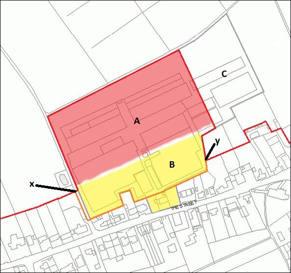
The original Settlement Confines between points X & Y are shown in orange. The updated Settlement Confines, incorporating areas A & B are in red. Other parts of the Settlement Confines, remote from the line X to Y, are unchanged and are in red.
POLICY WDP01 – Bisley Nursery Development
- The overall proposal; respects the existing grain, density and local character of the village; does not adversely affect neighbour amenity and results in no harm or adverse impact on the surrounding natural environment;
- 30% of the dwellings built on the site are affordable;
- The housing is a mixture of predominantly family two, three and four bedroom houses;
- Existing boundary hedgerow and trees are retained and existing boundary planting is enhanced through the planting of additional trees and hedgerow. A safeguarded landscape strip 5 metres wide is provided and retained within and around the edge of the site within which no development will be permitted;
- The house (Bisley) within the site close to The Street is demolished to allow integration of the Open Space and the housing development into the existing Village;
- A vehicular access is created at the existing location of Bisley House on The Street, with suitable visibility sight-lines and links to existing public footways from the site;
- Provision is made for public open space of around 1 hectare in area between the existing rear boundaries to residential properties that front The Street and the new housing development;
- Provision is made within the site for vehicular parking to serve the Village Hall;
- Proposals do not detract from the setting of the Heritage Assets (Conservation Area, Listed Buildings and Local Heritage List);
- A mitigation strategy to address any significant impact on the Thanet Coast and Sandwich Bay Ramsar/SPA/SAC is developed to the satisfaction of the Local Planning Authority, in consultation with Natural England. The mitigation strategy should include a range of measures, initiatives and contributions.
- A Phasing and Implementation Plan is developed to include a mechanism for creation of the Open Space, maintenance of the hedge and tree belts and provision of affordable housing for local use;
- Connection must be provided to the sewerage system at the nearest point of adequate capacity, as advised by Southern Water
Policy Note: Any development proposals must also comply with DDC's Core Strategy Policy CP5, Sustainable Construction Standards. A diagram of how the site might look, taking into account the Housing Proposals and Policy WDP 01, is shown in The Annex, Figure 2, Page 32.
- Timing for the transfer of land, on which the affordable housing is to be built, to Worth Parish Council; ideally prior to construction commencing;
- Provision of affordable housing in accordance with the ‘needs survey’ conclusions carried out by Action with Communities in Rural Kent (Ref 49-51), constructed to the specifications and standards of the Parish Council appointed Housing Association. Ownership of the Affordable Housing units and details of a transfer of ownership on a pre-agreed ‘at cost basis’ to the Housing Association. The timings to include details for completion of the affordable housing; for example that 50% of the affordable units are completed by the time half the open market housing is occupied;
- Timing for the transfer of land to be maintained as public open space, to Worth Parish Council following clearance of all buildings (including greenhouses), materials, rubbish and rubble and other related paraphernalia from the land and it’s re-seeding before the first occupation of any dwelling. Arrangements for maintenance of the tree belts to be detailed;
- Details of the layout and surfacing, including landscaping where necessary, of land for use as public car parking near The Street, prior to the first occupation of any dwelling;
All to be achieved by way of a legal agreement, which could be entered into under S106, or by a separate side agreement.
Additional Housing Proposals
The National Planning Policy Framework (para 58) encourages Neighbourhood Plans to develop robust and comprehensive policies that set out the quality of development that will be expected for the area. It expects such policies to be based on stated objectives for the future of the area and an understanding and evaluation of its defining characteristics.
If any development proposals come forward in addition to the allocated site (e.g. development of garden ground), the design and position should be considered in light of the character of the existing built form, including Heritage Assets, surrounding the proposal. In all cases, proposals should reflect the nature of the built environment, respecting the existing grain, density and local character described on, Page 12-14. DDC Core Strategy Policy DM 1 would apply to proposals for development outside the settlement confines.
POLICY WDP02 – Additional Development Proposals
Development proposals inside the settlement confines defined on Diagram 2 (including gardens) should be granted planning permission provided that the Heritage Assets and spatial character of the area (including the existing grain, housing density, street scene and local characteristics) are respected.
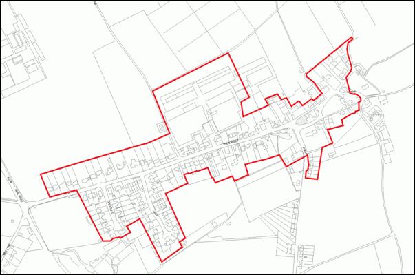
Diagram 2 –Updated Settlement Confines
Countryside Protection
Policy Background
National Planning Policy allows Neighbourhood Development Plans to identify for special protection Local Green Spaces. Green Belt like policies should apply to these and they should be capable of enduring beyond the Plan period.
DDC Core Strategy Policy DM 1 offers protection from development to the Countryside outside the Rural Settlement Confines unless specifically justified by other development plan policies, or it functionally requires such a location. Policy DM 25 provides protection from development to designated 'Open Spaces'.
Local Green Space Opportunities
Within the vicinity of the village the land is Grade 1 Agricultural Land. It is flat and intensively farmed as orchard, market gardening or arable. Protecting areas as Local Green Spaces provides an opportunity to protect from development areas, currently with no designation, that enhance the setting of the built environment, maintain the 'cluster nature’ of development and/or enhance the setting of Heritage Assets.
Local Green Space Options
The National Planning Policy Framework requires that Local Green Spaces be demonstrably special to local communities and Public Opinion research (Ref 35) was undertaken to ascertain if the community wished to protect areas as Local Green Spaces and, if so, which areas were most special to them. Because Local Green Space designation cannot cover extensive areas of land and must be in reasonably close proximity to the community, the consultation was limited to fifteen areas near the Settlement Confines (P1-P15).
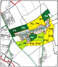
The Community wished to see areas designated as Local Green Spaces and expressed a significant preference for protection of four (P1, P2, P6 & P9) out of the fifteen areas. For details and an analysis see Annex, Page 34 to 36.
Local Green Spaces should be local in character and hold a special significance through, for example, beauty, historic significance, recreational value, tranquillity or richness of its wildlife.
The Parish Council approach to landscape can be found in Annex, 5.9, Page 36 and a Sustainability Assessment of the fifteen areas near the Settlement Confines was carried out to determine which, if any, of the fifteen areas held a special significance in maintaining the character of the Area. This identified 5 areas (P1, P6, P9, P11 & P15) as playing a significant role. For details and an analysis see Annex, Page 36
'Core' Local Green Space Areas that were most special to the Community and that were local in character and of local significance through safeguarding the built environment or Heritage Assets were identified by combining Community Opinion with the Sustainability Assessment (Annex, Page 42 to 43). Options were considered and the candidate areas finalised (Annex, Page 42 to 44) by maximising positive benefits while minimising protected area.
Local Green Spaces Proposals
- Area 1 is located on the north-western perimeter of the main settlement. It consists exclusively of agricultural land and it extends between housing on The Street and the Deal Road. It ensures the open character of the built environment is retained, resisting the coalescence of buildings on The Street and Deal Road. It retains the important open aspect on entering The Street.
- Area 2 is located in the heart of the main settlement. It is predominantly agricultural land and contains one rural dwelling which is on the Heritage Assets Local List (Page 25). The area extends from housing on The Street and Temple Way to Jubilee Road. It ensures the open rural character of the built environment at the heart of the main settlement is retained and it resists the coalescence of the built form of The Street/Temple Way and Jubilee Road. It links to, and helps protect the environs of the New Churchyard, an important Heritage Asset and area of designated 'Open Space' valued for its tranquillity.
New Local Green Space shown coloured green, designated areas of Open Space coloured grey.
POLICY WDP03 – Local Green Spaces
- Providing a degree of separation between parts of the built up area; or
- Enhancing the appearance of the built up area through its setting
Employment
Policy Background
DDC Core Strategy Policy CP 2 looks to identify land for employment. Non Strategic Core Strategy Policy DM 3 permits development of new Commercial buildings within the rural settlement confines or, with provisos, adjacent to the rural settlement confines. Policy DM 4 permits re-use of structurally sound buildings distant from the rural settlement confines for commercial, but not residential use. In supporting a prosperous rural economy the National Planning Policy Framework encourages Neighbourhood Plans to support sustainable growth through conversion of existing buildings, by promoting the diversification of agriculture and the development of tourism.
Employment Opportunities
Despite the surplus of industrial land in the wider area (Betteshanger & Sandwich, including the Discovery Park Enterprise Zone), lack of employment is the main reason why people leave the Neighbourhood Area (Ref 26).
Due to the local surplus, The Plan does not seek to designate new 'Industrial' employment land. Instead it encourages sustainable employment by focusing on the areas key strengths in agriculture and the hospitality industries, as well as supporting re-use of the three identified Brownfield Sites (Page 30).
Agriculture & Tourism
Already a key local employer, agriculture is an important contributor to sustainable employment and The Plan both recognises and supports the role of agriculture in the local economy and the importance of Grade 1 Agricultural Land on which it depends. The Vision for the Area addresses non Land Use issues through Community Objectives 2 - Employment.
New development needed for agricultural purposes is supported provided it is located adjacent to existing farm buildings, within the current curtilage of the farmyard. If this is not possible, and development would encroach onto Grade 1 land, proposals should be justified on grounds of operational need. New buildings should be kept to the minimum size needed for the purpose.
Development that leads to more congestion and makes it more difficult for farmers to access fields off Gore Top Lane from Jubilee Road and The Street are unlikely to be supported.
Development Proposals
The Site is surrounded by farmland (mainly producing salad crops), but it is close to the Thanet Coast and Sandwich Bay Ramsar site. It is within 200 metres of the planned RSPB Nature Reserve and its entrance is opposite a Scheduled Monument.
The Worth Centre buildings are under-utilised and their use for craft, small-scale light industry or agriculture, to provide further local employment is supported, provided it does not adversely impact amenity, the nearby Ramsar site or significantly increase traffic in Jubilee Road.
POLICY WDP04 – The Worth Centre Buildings
- Proposals do not have a detrimental impact on residential amenity;
- Traffic and highway issues are satisfactorily addressed;
- Any redevelopment of the site should not result in a net increase in the total footprint of buildings on the site;
- No significant negative impact on the Thanet Coast and Sandwich Bay Ramsar site would occur
Diagram 4 - 'Development of the Worth Centre.'
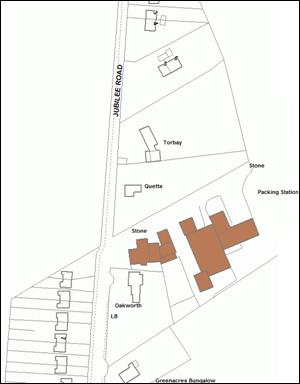
Existing buildings coloured brown
While the buildings are outside the Settlement Confines, National Planning Policy encourages the conservation and enhancement of the historic environment. Re-purposing of the Old Mill Buildings as combined accommodation/workshop units would not only provide sustainable employment, but would help to ensure a future for this important Heritage Asset. Thus, the use of the Old Mill Buildings on Mill Lane as accommodation units, if coupled directly with workshops, is supported.
To the west of the building is farmland, but the Thanet Coast and Sandwich Bay Ramsar site is just over 100 metres distant. The site has direct access to Mill Lane approximately 200 metres from the A258.
POLICY WDP05 – The Old Mill Buildings
- The current footprint of the existing buildings is not exceeded;
- No new buildings are erected;
- Traffic and highway issues are satisfactorily addressed;
- Adequate parking is provided;
- No significant adverse impact on the Thanet Coast and Sandwich Bay Ramsar site would occur
Diagram 5 - 'Development of the Old Mill, Mill Lane'
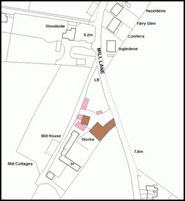
Change of use of buildings in pink (workshops) and brown (accommodation & workshops) is supported.
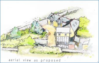
The buildings at the Old Mill showing how they will look after improvement under approved planning applications DOV/00/0806 or DOV/05/00985 - these improvements do not include any provision for a change of use.
Delivery and Monitoring of Development
The Worth Neighbourhood Plan, if adopted, will become part of the Dover District Council Statutory Planning Policy Framework. It will be used to determine planning applications and guide planning decisions in the Neighbourhood Area.
The Parish Council has had repeated contact with the owner(s) of allocated site(s) to, investigate whether there are any likely barriers to the development and to establish realistic assumptions about the timing of development. The cost of requirements likely to be applied to development proposals, such as connection to the sewage network and the meeting of 'on-site' Community Plan Objectives, have been taken into account to ensure that overall the Plan's proposals are economically viable.
There is a formal requirement for Dover District Council to produce an Annual Monitoring Report. The District Council will consider the outcomes of the Annual Monitoring Report and decide whether there is a need to review existing plans, or to produce any additional ones. Where targets are not being met the District Council will identify the relevant issues, analyse the problem and propose remedial action if necessary. The Worth Neighbourhood Development Plan Proposals (if adopted) will be included in the District Council Annual Monitoring Report and, depending on the outcome, in association with the District Council, the Parish Council will decide if any action is required.