3. Development Sites
Amount and General Location of Development
3.1
The amount and general location of employment and retail development to be accommodated by the Plan have been set out in Chapter 2. With regard to housing development the Core Strategy has identified that land should be allocated for 14,000 new homes with a target to complete a minimum of 10,100 by 2026. This Plan identifies the sites that are allocated to help fulfil the Core Strategy's requirements (see Core Strategy Policy CP3)
Table 3.1 Housing Land Requirements for the District (as at 1 April 2012)
|
|
Dover |
Deal |
Sandwich |
Rural Areas (1) |
|
Total Housing Requirement Identified in Core Strategy
|
9700 |
1600 |
500 |
1200 |
|
Less sites identified through Strategic Allocations
|
-6650 |
|
|
|
|
Less sites identified through Planning Applications (includes completions and unimplemented full consents) |
-1460 |
-930 |
-270 |
-370(2) |
|
Housing requirement needed to fulfil the Strategy |
1590 |
-670 |
230 |
830 |
|
Number of dwellings allocated in the Land Allocations Local Plan |
1010 |
570(3) |
180 |
705 |
|
Unidentified requirement |
580(4) |
100 |
50 |
130 |
|
Predicted windfall(5) allowance over the Plan Perios (2014-26) (6) |
914 |
337 |
10 |
135 |
1. In addition, land is allocated at Aylesham for 1,000 dwellings through Saved Local Plan policies
2. Planning permission for the Aylesham Development Area (DOV/07/00181) for 191 units has been deducted to prevent
double counting with the saved Local Plan allocation
3. Policy LA10 land to the north west of Sholden is counted within planning applications as full planning permission has
been granted and it is under construction
4. Site at Western Heights & Farthingloe, Dover for 560 residential units, has a resolution to grant planning permission
(May 2013). This has not been included within the calculations
5. Windfall sites are those which have not been specifically identified in the Plan
6. The Windfall rate for dwellings over the last five year period (2008-2013) is 703 in Dover town; 259 in Deal; 8 in Sandwich;
and 104 for the Rural Area (including Aylesham). If the average yearly rate over this period is then taken for the remaining
13 years (up to 2026) this would equate to 1828 dwellings in Dover, 673 in Deal, 21 in Sandwich and 270 in the Rural
Area
The District Council has, however, made the assumption that, as the Land Allocation Local Plan will allocate sites for
development the scope for windfalls will be reduced. It is, therefore, considered realistic that only half of the number of
windfalls (50%) will come forward during the Plan period.
The Windfall allowance would be sufficient to meet the unidentified requirement in Dover, Deal and the Rural Area.
Sandwich is the exception but the District Council now has a resolution to grant a planning application at Discovery
Park that could meet the unidentified requirement.
3.2
The above requirements need to be adjusted to take account of the strategic allocations made in the Core Strategy, housing completions since 2006 and the stock of unimplemented
permissions. Table 3.1 sets out the residual amount to be allocated in this Plan in each part of the District after taking account of these factors.
3.3
The Core Strategy figure of 1,200 dwellings for the Rural area, is not distributed to particular settlements in the hierarchy, nor divided into rural north or rural south. Policy CP1 of the Core Strategy sets out a Settlement Hierarchy which details the general role of individual settlements. The second half of the hierarchy provides the general basis for the distribution of development across the rural area and is reproduced in Table 3.2.
Table 3.2 Extract of Settlement Hierarchy from the Adopted Core Strategy 2010
|
Settlement Type |
Function
|
Town/Village |
|
Local Centre |
Secondary focus for development in the
rural area; suitable for a scale of
development that would reinforce its role
as a provider of services to its home and
adjacent communities
|
Ash
Capel-le-Ferne
Eastry
Shepherdswell
Wingham
|
|
Village |
Tertiary focus for development in the
rural area; suitable for a scale of
development that would reinforce its role
as a provider of services to essentially
its home community
|
Alkham, East Langdon, East Studdal,
Elvington, Eythorne,Goodnestone,
Kingsdown, Great Mongeham, Lydden,
Nonington, Preston, Ringwould, Ripple,
St. Margaret's, Staple, West Hougham,
Woodnesborough, Worth
|
|
Hamlet |
All other settlements in the rural area; not All other settlements
suitable for further development unless
it functionally requires a rural location
|
All other settlements |
Site Selection Process
3.4
This Plan has been prepared following two public = participation stages. After a 'call for sites' in 2005, public engagement on the Preferred Options took place in 2008. This Plan was then put on hold until the Core Strategy was adopted in 2010. As a significant time had lapsed, the District Council undertook another call for sites in 2010 and a further public engagement exercise for the new sites also in 2010 (this was called the 'Interim Consultation').
3.5
In 2008/9 the District Council produced a Strategic Housing Land Availability Assessment (SHLAA). This assessment considered all the sites that had been submitted by landowners and developers to the Council for consideration for development as part of the Local Plan. As part of the initial assessment process the SHLAA screened the sites
against a list of criteria based on national policies and size. These included designations such as Areas of Outstanding Natural Beauty (AONB), Heritage Coast, national and European nature conservation sites and areas within Flood Zone 3. All sites less than 0.17Ha were excluded from the SHLAA.
3.6
Building on the assessment for the SHLAA and with input from specialists in conservation and heritage, ecology and highways (KCC), a more in depth analysis of every site has been undertaken. Sustainability Appraisal (SA) has been used to help identify issues, test options and identify the preferred option that forms the basis of this Plan. Further details are contained within the SA Report.
Kent Downs Area of Outstanding National Beauty (AONB)
3.7
The Kent Downs AONB, covers substantial parts of the south of the District. The AONB is an area of high scenic quality with statutory protection in order to conserve and enhance
the natural beauty of their landscapes (See NPPF, para 115). Consideration must be given not only to the impact development could have on the AONB, but also the impact on the setting of the AONB. The AONB is particularly a constraint to development in the settlements where the boundary is immediately adjacent to the existing built development. In Capel-le-Ferne, Kingsdown, Lydden, and St.Margaret's there are very limited development
opportunities that would not damage the setting of the AONB or the character of the village itself. The villages of Alkham and West Hougham are located entirely within the AONB, and although this does not restrict development entirely, it is a key factor which must be taken into account as part of the assessment of sites. In general, the Plan has sought to avoid
making allocations in the AONB, except where they are small-scale where they are well related to the existing settlement and there are no other viable options. Where allocated they need to be sensitively designed, appropriate to the location, and in accordance with the adopted Kent Downs Management Plan and its supporting guidance (e.g the Kent Downs Landscape Design Handbook).
Heritage Coast
3.8
Where the AONB meets the coast it has been designated a Heritage Coast. The national purposes of Heritage Coast designation includes to conserve, protect and enhance the natural beauty of the coasts, their marine flora and fauna, and their heritage features.
Flood Risk
3.9
To the north east of the District, from an area covering the northern part of Deal and Sandwich up to the boundary line with Thanet, there are large areas at risk from tidal flooding
(Flood Zone 2 and 3). The Environment Agency are improving the sea defences at both Deal and Sandwich, which will reduce the likelihood of flooding. Flood Zone 3, which equates to those areas at greatest risk of flooding, is divided into Flood Zone 3a and Flood Zone 3b. The Council has applied the sequential test to site approach, as set out in paragraph 100 of the NPPF, to avoid where possible flood risk to people and property. Sites which are located within Flood Zone 3b, the functional floodplain, have been considered unsuitable given the risk to human life of flooding.
3.10
The areas at risk of flooding in Sandwich and Deal are tidal, in contrast to the areas in Dover which are fluvial from the River Dour. The Core Strategy recognised that the River Dour is a central, but underplayed, structural feature of the town. Core Strategy Policy DM18 reflects the need and desire to improve the prominence of the River for any development proposals which affect the setting of the River.
International and National Wildlife Designations
3.11
International and National sites of importance for wildlife include Ramsar and European sites (Special Areas of Conservation and Special Protection Areas) as well as Sites of Special Scientific Interest. These primarily occur on ancient woodland, chalk grassland and the coast. The last includes extensive sites on the coastal dunes, mudflats, marshes and fen to the northeast where there is also risk of flooding.
Employment Allocations
3.12
The Employment Update assessed each saved Local Plan employment allocation and examined the need for non-B class uses.
3.13
Taking into account the Sustainability Assessment which formed part of the Employment Update, and the Core Strategy’s approach to the distribution of employment land, nine sites are identified as initial priority sites for employment uses, although some of these have the benefit of extant planning permission(7). Details of the employment allocations are set out in each section of this Plan. A summary is included in the table below:
Table 3.3 Distribution and type of employment allocations across the District
|
Site |
Location |
Use |
Amount of floor sopace(m2) |
Policy reference |
|
St. James's Area |
Dover |
Retail |
10,500 |
Saved Local Plan
Policy AS9
|
|
White Clifs Business Park |
Dover |
Focus on
B1/B2/B8
|
53000 in addition to unimplemented
p l a n n i n g consents of 71,800 |
|
|
Albert Road |
Deal |
B1/B2 |
4550 |
Saved Local Plan
Policy LE5
|
|
A y l e s h a m Aylesham Development Area
( e m p l o y m e n t allocation)
|
Aylesham |
B1/B2 |
8000 |
Saved Local Plan
Policy AY4
|
|
B e t t e s h a n g e r Colliery Pithead
|
Deal |
B1/B2/B8 |
22000 |
Saved Local Plan
Policy AS1
|
|
Eastry Hospital |
Eastry |
B1 and emoployment generating uses. |
2000 |
Rural - Policy LA29 |
|
Tilmanstone Spoil Tip (North) |
Deal |
B2 |
1350 |
Saved Local Plan
Policy LE10
|
7 Table 3.3 excludes Old Park Barracks and Ramsgate Road both of which have an extant planning permission, and Discovery Park Enterprise Zone (See paragraph 3.14
Discovery Park Enterprise Zone
3.14
Discovery Park Enterprise Zone, formerly Pfizer’s Research and Development facility, at Sandwich has an established employment function. It is the largest employment site in
the District and comprises around 280,000 m2 of high quality research and development buildings, offices and ancillary facilities set within a landscaped campus. Having achieved
Enterprise Zone status in 2011, the site offers business rate discounts, has the potential for improved superfast broadband and future capital allowances to investors and occupiers on site. The planning mechanism for implementing an Enterprise Zone at Discovery Park is a Local Development Order (LDO). A LDO is intended to encourage new start-up businesses and other investors with simplified planning rules.
3.15
The LDO removes the need to make planning applications for some types of development on the site. It provides a clear framework for business development making it easier to achieve economic growth.
3.16
Discovery Park Enterprise Zone is being marketed towards life sciences, Research and Development (R&D) and business start ups. The Employment Update (2012) has
recommended that the White Cliffs Business Park (WCBP) continues to be restricted to B1/B2/B8 uses and other employment generating uses. Discovery Park should remain the focus for high tech research companies making the best use of the existing high quality buildings and facilities and marketed towards businesses that are not going to locate in the WCBP. The Council’s employment strategy is, therefore, based on the premise of retaining the sites in Table 3.3 that have been identified as initial priority for employment uses as they each create and offer different employment opportunities.
Types of Site Allocation
3.17
For each settlement where allocations are made a description of the settlement is given, followed by site allocations. These are colour coded according to the type of allocation on the diagrammatic figures at the beginning of each section:
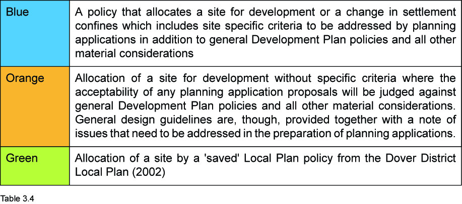
|
Each policy that allocates a site for residential development includes an estimate of capacity. The estimate of capacity is needed to calculate whether the Plan’s proposals meet the Core Strategy’s overall requirements for housing land allocations. The estimate is derived by applying a gross density of 30 dwellings per hectare, unless otherwise stated. This reflects the minimum set by Core Strategy policy CP4 and is designed to provide a generally conservative estimate of overall capacity of the Plan’s housing allocations. When specific schemes are developed for planning permission the Council, in accordance with policy CP4, would be seeking for the design process to demonstrate that the resultant density makes the most efficient use of land consistent with the principles of good design. This may result in increased capacity.
|
3.18
Whilst policies seek to identify principal issues, it is strongly recommended that early engagement is made with the Local Planning Authority. The Council offers pre-application advice; further details are available at:
http://www.dover.gov.uk/planning/fees_and_charges/charging_for_pre-application_a.aspx
3.19
There are a number of planning applications with the benefit of full planning permission or which have a resolution to grant. This Plan provides guidance in case these permissions lapse without development occurring.
3.1 DOVER
3.20
The Dover area consists of urban wards and the built up parts of the parishes of River, Temple Ewell and Whitfield, which form a continuous built up area. This urban area has 18,972 dwellings(8) and a population of 42,397(9). Dover town centre contains the principal convenience and comparison shopping offer with some residential and office space. A medieval street pattern is mostly visible in the town centre until Townwall Street which divides the town centre from the seafront. The architecture of the town centre is predominantly Victorian and Edwardian. Although there has been post war infill and some more recent development such as Dover Discovery Centre and the new Dover Sea Sports Centre. The docks have their own industrial maritime character with large areas of hard standing enclosing significant water bodies.
(8) 2011 Census - Table QS418EW
(9) 2011 Census - Table QS103EW
Dover Character Areas
3.21
In order to establish design objectives for the town of Dover and to provide additional guidance on interpreting and implementing Core Strategy Policy CP4 (Housing Quality, Mix, Density and Design), twenty two character areas have been identified (see Table 3.6). These have been developed using the following criteria:
-
Degree of expected change identified in the Core Strategy;
-
Major land uses and function of the town;
-
Historic development and architectural period;
-
Landmarks (historic or otherwise);
-
Significant areas of open green space and landscape character; and
-
Strategic movement and connectivity routes.
3.22
The urban character areas identify the function of each area. They should be used be used as the starting point for any development proposals. Developers, through the accompanying design statement, will need to set out how the character area has been used to influence the design of the proposed development. Many of the character areas have similar objectives but it is possible to identify five broad categories in which the areas fall. The categories are:
3.23
Each area has a relationship with neighbouring character areas. Where development abuts another character area the proposed development should demonstrate how it addresses the overall objectives of each.
Figure 3.1 Dover Character Areas
|
Urban Areas
|
12 Connaught Park |
|
1 Whitfield |
13 Burgoyne Heights |
|
2 White Cliffs Business Park |
14 Duke of Yorks School |
|
3 Connaught Barracks |
15 Dover Castle |
|
4 Town Centre and Waterfront |
16 Eastern Docks |
|
5 Western Docks |
17 Aycliff |
|
6 Western Heights |
18 Folkestone Road |
|
7 Coombe Valley |
Landscape Areas
|
|
8 River/Crabble |
19 Coombe Valley |
|
9 Buckland Valley |
20 Edinburgh Hill |
|
10 Buckland |
21 Long Hill & Guston Farmland |
|
11 Tower Hamlets |
22 Old Park & Temple Ewell |
Table 3.6 Character Areas
Urban Grain and Structure
3.24
Dover is located in an exceptional and defining setting and has an extremely clear urban structure and grain. It has a dominant north-south spine following the River Dour and
east-west valleys branching off the spine. A significant proportion of the countryside which surrounds existing development, particularly to the west, is protected as AONB. Key heritage assets are in the town centre and on the flanking cliff tops. The Western Height fortifications and Dover Castle are the main landmarks, they play an important role in legibility and wayfinding and are key to Dover's urban identity. See Core Strategy Figure 3.3 Dover Spatial Issues.
Core Strategy
3.25
The Core Strategy identified that there needs to be a significant amount of change to Dover town centre. This is focused on the need to reinforce and restore the function and character of the town centre alongside the planned housing development at Whitfield and Connaught Barracks.
3.26
Whilst Dover has been identified in the Core Strategy as the main focus for action, it is also where there is most potential for transformation. The Core Strategy set a number of key objectives for the regeneration of the town:
-
attract working age families to support growth in the economy;
-
increase the attractiveness, making Dover a place to live, work, visit, shop and spend
leisure time;
-
improve the housing market perception and housing offer;
-
improve the ease of, and reduce the need to, travel; and
-
protect and enhance the historic environment whilst supporting regeneration.
3.27
In order to increase the attractiveness and address the under-performance of the town, there are a number of proposals identified in the Core Strategy that would directly assist with the regeneration of Dover:
-
Redevelopment of the St James’s area just north of Townwall Street for new retail development and a hotel that will enhance the retail offer and appeal in the town centre. Since the Core Strategy was adopted 10,600 square metres of A1 has been granted planning permission at the St. James’s area along with a new hotel on the corner on Woolcomber Street and Townwall Street.
-
The Mid Town area, which is a strategic allocation in the Core Strategy (Policy CP9), has been identified as being suitable for a mixed use development that will assist with improving the educational provision in Dover.
-
Dover Waterfront, which is a strategic allocation in the Core Strategy (Policy CP8), has been identified as being suitable for a mixed use waterfront scheme including retail, restaurants, cafés and drinking establishments, assembly and leisure, residential (at
least 300 homes), office and hotel uses. The intention is that it becomes a major attraction and modern day symbol for Dover.
-
Terminal 2 - a new ferry terminal and marina at the former Western Docks to cater for the forecast increase in traffic and maintain the Port of Dover’s leading role. A Harbour Revision Order (HRO) has been granted for Terminal 2.
3.28
The allocations that have been identified in this Plan will complement the above proposals and address the objectives that have been set out in the Core Strategy for Dover.
Town Centre Boundaries
3.29
The redevelopment of the St. James’s Area will become an important anchor to the southern end of the town centre and help deliver significant improvements. This will be further enhanced by the development of the Dover Waterfront area.
3.30
The town centre boundary has been amended to include the majority of the allocation (excluding the marina in Wellington Dock and the area of land covered by the HRO). The boundary has also been amended to include units fronting Snargate Street, an opportunity area for town centre uses which would complement the uses at Dover Waterfront.
Provision of Infrastructure
3.31
The Core Strategy recognised that any physical planned changes to the town must be accompanied by the necessary infrastructure. The introduction of the High Speed 1 (HS1) service to London from Dover Priory Railway Station has dramatically reduced journey times to London to just 67 minutes. The commencement of this train service has provided a step-change in the accessibility of Dover to London; for additional information on this area of change please see paragraph 3.120.
3.32
The need for a fast and reliable express public transport system to increase accessibility and reduce the number of trips made by private car was a key component of the Dover Transport Strategy and the Core Strategy. This is being delivered by proposals for a Bus Rapid Transit (BRT) which will provide a public transport connection from the planned urban extension at Whitfield, White Cliffs Business Park (WCBP) via Connaught Barracks/ Dover Castle to the town centre and Dover Priory railway station. The potential route alignment between the roundabout on the WCBP to Connaught Barracks has been developed with the assistance of Kent County Council (KCC).
3.33
The need to enhance opportunities for walking and cycling as viable and effective means of transport between key parts of Dover has been taken forward by KCC's River Dour Greenway project, which provides an important ‘backbone’ that will improve links across Dover town. Furthermore, the River Dour Greenway links in to local and national cycle networks (NCN) such as NCN Route 1 and NCN Route 2.
3.34
In order to strengthen the proposals for green infrastructure network in the AONB, especially in the chalk grassland around Dover, European funding has been secured, through the Heritage Lottery Fund, to develop a Landscape Conservation Action Plan. The focus of the Action Plan is to understand the landscape characteristics and heritage assets and create a positive action plan that can be taken forward to improve the landscape.
Purpose of housing provision
3.35
The Core Strategy identified that the ‘dominant housing provision purpose’ in Dover is to ‘Create’ and ‘Restore’ with the aim to:
-
re-balance the stock away from traditional small scale terrace housing;
-
improve quality of appearance and standards of sustainable construction;
-
provide family housing but also cater for an ageing population;
-
improve environment and housing standards of areas with low quality issues; and
-
improve overall market appeal and image.
3.36
The design of the housing will have a leading role in shaping the new market that is to be created in a way that addresses the existing housing deficiencies identified in the Core Strategy. Proposals must raise quality to enhance the market perception and appeal of Dover.
3.37
Where the focus is to ‘restore’ and ‘re-balance’ the housing stock, the main purpose of allocating sites is to improve the general quality and appearance of Dover. Elsewhere all other site allocations should ensure that the design aims to restore existing character and urban form.
Areas of change
3.38
In Dover there are parts of the town that are either in need of renewal, or that do not fulfil their potential but where proposals are not sufficiently advanced in order to justify a specific allocation in this Plan. These areas are identified as 'Areas of Change’ - further detail are provided in Section 3.1.1.
Employment
3.39
This section sets out the employment land allocation at Dover for White Cliffs Business Park (WCBP). WCBP and Discovery Park are the District's premier locations for future employment generation as they are both well served by main roads.
White Cliffs Business Park
Site Location and Characteristics
3.41
WCBP is located to the north of Dover Town, immediately to the south of the A2 and the managed neighbourhood expansion area. It is adjacent to the A2 and accessed from the dumbbell roundabout (A2/A256 interchange) and the Whitfield roundabout. A spine road, which runs through the WCBP, connects these two access points.
3.42
Phase II has outline planning permission; this is connected to Phase I via the spine road. Phase III does not have the benefit of planning permission and comprises agricultural land.
Site Context
3.43
Phase II of the WCBP is open to long views from the north and west and is readily seen from the A2. Owing to the topography of Dover, development may be visible from a considerable distance. Phase III of the WCBP is also open to views, especially from the west. Phase III lies to the west of residential properties on Dover Road in Guston. Byway ER55A bisects the site and byway ER60 runs along the eastern boundary.
Proposed Development
3.44
Phase II and Phase III are suitable for Use Classes B1, B2 and B8. Based on the Employment Update other employment generating uses will be permitted subject to assessment in terms of their contribution to sustainable development. This is restricted to other employment generating uses that are not specified in the Use Class Order.
3.45
The existing spine road that links Phase I to Phase II is considered to be in principle, capable of accommodating the BRT (see paragraph 3.32). Any development that takes place in the WCBP will need to maximise the use of public transport through enabling and contributing to the BRT system proposed in the Core Strategy. Planning applications in Phase III will need to incorporate proposals to connect the BRT system to Dover Road. Traffic management measures will need to be put into place at the end of the WCBP to restrict access onto Dover Road to only BRT and emergency access. In order to encourage public transport patronage from employees it is important that proposed development is
designed to ensure that pedestrian routes to each BRT stop are clearly defined, safe, well-lit and subject to natural surveillance. This key objective should form part of any design proposal in any subsequent proposals for the WCBP. A key component of ensuring new development promotes legibility, natural surveillance, and way finding is through the orientation of buildings which should front the main spine road.
3.46
The North Downs Way which is located within Phase II and separates it from Phase III, will need to be retained and enhanced except where the access road from Phase II to Phase III needs to cross the North Downs Way. Along the remainder of the North Downs Way the existing hedgerow must be retained and strengthened by structural planting. Any development must be set back from the new planting to preserve its setting and integrity. Development proposals should explore the option of creating a new 'green bridge' pedestrian connection across the A2 to improve the setting and directness of the North Downs Way.
3.47
A shelter belt consisting of dense native planting will be required along the southern boundary. Phase III of the site adjoins housing on Dover Road. The amenities of residents in this area will be protected by establishing a landscape buffer at least 25 metres wide consisting of earth bunding and dense native planting, and allowing only B1 development at low density in this location. The remaining land, without the benefit of planning permission, has the potential for some 53,000 square metres of floorspace.
Policy LA2 – White Cliffs Business Park
he site is allocated for employment development. Planning permission for Phases II and III will be permitted provided:
-
development is for Use Classes B1/B2/B8, and employment generating uses that are not specified in the Use Classes Order;
-
proposals maximise the potential use of public transport and ensures development fronts the main spine road and includes clear and safe pedestrian routes for public transport stops;
-
the integrity and setting of the North Downs Way is preserved and enhanced by retaining the existing hedgerow, strengthening by additional planting of three metres either side of the North Downs Way, and setting back development 10 metres from the new planting, or a new 'green bridge' pedestrian connection is delivered across the A2 to improve the setting and directness of the North Downs Way;
-
Byway ER55A is retained and enhanced;
-
structural landscaping is carried out at the sites' main boundaries.
Additionally, in the case of Phase II:
-
a treeshelter belt at least 20 metres wide along the southern boundary is provided;
-
no building is constructed within 15 metres of the shelter belt;
-
no building constructed within 50 metres of the shelter belt exceeds 10 metres in height; and
-
vehicular access and servicing extends up to the boundary with Phase III.
Additionally, in the case of Phase III:
-
proposals incorporate measures to provide a direct and convenient BRT route to Dover Road;
-
traffic management measures are introduced that restrict access to Dover Road to BRT/emergency access;
-
a landscaped buffer zone at least 25 metres wide in the vicinity of Dover Road is provided; and
-
development adjacent to the buffer zone is Use Class B1 only and does not exceed 10 metres in height.
view map
To see this policy on the interactive map, click here
To read the full document, click here (Opens a PDF in a new window)
Residential
3.48
The Core Strategy has identified an ambitious 9,700 dwellings to regenerate Dover town. Taking into account the planning permissions and completions Table 3.1 has identified that land is needed in Dover to accommodate 1,590 dwellings. The Plan has allocated twelve sites for approximately 1,010 dwellings.
3.49
Historically, over the period from 2006 to 2011, Dover town has had a total of around 500 dwellings which were completed that fall within the category of ‘windfall’(10). Through the Local Plan process it has been possible to identify approximately 94% of this requirement; these allocations are detailed within the Dover section of this Plan. The remaining requirement of 6% (580 dwellings) will not be allocated and is expected to be met through windfall sites. These sites will not be considered within the first five years of the Plan.
3.50
The next section of the Plan contains policies for residential development sites where there are specific issues. Subsequently, Policy LA10 allocates sites for residential development or changes to the settlement confines; this contains issues identified as part of the site analysis that require careful consideration.
Charlton Sorting Office, Charlton Green
Site Location and Characteristics
3.51
The 0.69 ha site occupies a prominent location at the signalised junction of Frith Road and Charlton Green on a busy one way system. The site is also on the secondary junction of Frith Road and Salisbury Road, which is to the north. The access to the site is from Charlton Green at the southern most corner of the site.
3.52
There is an existing two storey building on the site, a former Royal Mail sorting office, which fronts Frith Road and Charlton Green. There is hard standing to the rear of the building. The building is being used as a training centre, offices and gym.
3.53
The site is flat but sits within a topography that gently rises to the north. Vegetation on the site is limited to grass and ornamental trees along the frontage of Frith Road and Charlton Green. Southern Water has advised that a sewer crosses this site.
Site Context
3.54
Charlton Green separates the site from an edge of centre retail development, which is located to the south west. There is on-street parking adjacent to the site on Charlton Green. The remaining area around the site is predominantly high density residential properties of two, three or four storeys. The properties to the rear, fronting Salisbury Road, are elevated and overlook the site. The properties located to the west, fronting Frith Road, are located within the Charlton Green Conservation Area. This Conservation Area is centred on St. Peter and St. Paul's Church, which is listed.
3.55
The River Dour is located to the south west on the opposite side of Charlton Green, flowing in a culvert between the road, land set aside for car parking and the Charlton Green retail development. The presence of the River means that Charlton Green has been identified as within an area at risk of flooding (Flood Zone 3). The area that is at risk of flooding abuts the site but does not include it.
3.56
The site lies within the Connaught Park and the River Dour Character Areas. The site also abuts Town Centre and Waterfront Character Area (see Figure 3.1).
Proposed Development
3.57
The site lies on the edge of a predominately residential area and is within walking distance to Dover town centre. Whilst this site could provide an opportunity for an edge of centre retail development or an employment use, the Dover District Retail and Employment Updates (2012) clearly indicate that the Core Strategy's requirements are more than adequately accommodated through existing provision or existing allocations. Suitable and available sites for residential development in the town are, however, limited. The site is,
therefore, considered to be a suitable location for residential development as it can assist with improving the overall market appeal and the image of this part of Dover.
3.58
Integral to the development will be the need to create a design that reflects and takes into account the site's prominent position on the one way system which is at the interface of several character areas. The position of the site would lend itself to a frontage development and there is the opportunity to create a design that reinforces local distinctiveness and enhances the character areas. The design must be of sufficient quality and appearance to enhance this part of Dover through the creation of a landmark building. The selection of appropriate architectural style will be of great importance, given the adjacent Conservation Area.
3.59
The remaining part of the developable area, along the frontage of Frith Road and Charlton Green, should be at a scale that would takes into account the surrounding residential urban form. Development to the rear of the site is considered to be unsuitable due to issues of overlooking from existing properties on Salisbury Road but could be used for parking or amenity space.
3.60
Early discussions should take place with Southern Water regarding the sewer that crosses the site, which would need to be taken into account as part of any planning application.
3.61
The housing mix should be informed by the Strategic Housing Market Assessment (SHMA) but the particular characteristics of the site lend it to a mixture of town houses and flats. Vehicular access onto the site should be from the existing access from Charlton Green. This is due to the site's relationship with the signalled junction and on street parking. Proposals will also be expected to be informed by a detailed Flood Risk Assessment.
Policy LA3 – Charlton Sorting Office, Charlton Green
The site is allocated for residential development with an estimated capacity of 65 dwellings. Planning permission will be permitted provided that:
-
the design incorporates a landmark building having particular regard to the site's prominent location and its relationship with the Charlton Green Conservation Area, Charlton Green, and Frith Road;
-
the overall development should be at a scale complementary to neighbouring residential properties;
-
the development should provide a connection to the sewerage system at the nearest point of adequate capacity and ensure future access to the existing sewerage infrastructure for maintenance and upsizing proposals; and
-
vehicular access to the site is from Charlton Green.
view map
To see this policy on the interactive map, click
here
To read the full document, click here (Opens a PDF in a new window)
Albany Place Car Park
Site Location and Characteristics
3.62
The 0.40ha site is located to the west of York Street, and is situated on rising ground lying immediately below Western Heights. It is located close to the town centre and has spectacular views of Dover Castle and the Port. The Western Heights Conservation Area covers the north and west portions of the site. The site falls within the Town Centre and Waterfront Character Area and abuts the Western Heights Character Area (see Figure 3.1).
3.63
The site is currently in operation as a public car park, which is split into three separate sections providing approximately 90 parking spaces overall. This car park serves the town centre and Western Heights. Albany Place connects to Adrian Street and divides the site. The largest section, to the east of the road, is located on a slope, which rises to the western boundary. All three sections are floodlit.
Site Context
3.64
The site lies at the bottom of the main pedestrian access (via steps) to the Drop Redoubt part of the Western Heights fortifications. Albany House, which borders the site to the north, is a three storey sheltered housing block. Beneath this building lies part of the Roman fort of the Classis Britannica which is a Scheduled Monument. The site is likely to contain nationally important archaeological remains connected with this fort, including associated settlement and burials. Dover Castle lies to the north east, in an elevated position making it highly visible from this location, and similarly the site is visible from Dover Castle. The Western Heights is a Scheduled Monument; proposals should take particular care to avoid harm to the setting. Consequently, the area is very sensitive for archaeology.
3.65
Residential properties, including almshouses, are located to the south, east and north. The upper windows of adjacent terraced housing to the south overlook the largest section of the site at head height. The almshouses are located to the north, a flint wall provides demarcation with the site and these properties lie within the Conservation Area. A stone wall encloses the western boundary, and beyond lies Cowgate Cemetery. There is a raised footway which is located between the stone wall and the cemetery and overlooks the western portion of the car park.
3.66
While, the Dover Parking Strategy (2007) has identified that Albany Place Car Park could be closed without resultant capacity problems within the town centre car parking stock, there is a need to accommodate the temporarily displaced users from Russell Street Car Park during the construction of the St. James's scheme. Evidence to show that replacement car parking has become available in the town should be included as part of any proposals.
Proposed Development
3.67
This site offers a unique opportunity for redevelopment that maximises the views of Dover Castle and the Port. Archaeological desk-based assessment and field evaluation
works may be required to inform any future development proposal. Given the sensitive nature of the site and its setting, Figure 3.3 in the full PDF document sets out the constraints and opportunities presented by the site. The diagram divides the site into two areas, which are split by Albany Place. Any
redevelopment proposals would need to retain the connection between Albany Place and Adrian Street.
3.68
The smaller area, to the west of the road, is the more sensitive area, particularly given that the northern part is within the conservation area. The opportunity exists to continue the built form of the almshouses.
3.69
The larger area, to the east of the road, is constrained by changes in topography, long distance views, and the Scheduled Monument to the north. Development should front
Albany Place following the curvature of the road, and offers an opportunity to create background buildings although development should reflect the site's setting amidst the Heritage Assets. Existing residential development to the south is lower lying, and new development would need to be designed to reduce overlooking to these properties on Adrian Street. In addition, the development should be designed to minimise the impact on long distance views from Dover Castle.
3.70
The location close to the town centre provides an opportunity for a reduced amount of car parking on site to reflect Core Strategy Policy DM13. There is an opportunity for a higher density scheme reflective of the location, and based on 40dph the number of dwellings would be approximately 15. The site would be suitable for a range of dwelling sizes, including both family housing and larger flatted development; the main purpose to create and restore the character of Dover through improving the townscape.
Policy LA4 – Albany Place Car Park
The site is allocated for residential development with an estimated capacity of 15 dwellings. Planning permission for residential development will be permitted provided that:
-
an overall assessment (and resultant implications) of car parking provision in the town centre is submitted and considered satisfactory; and
-
it does not result in substantial harm to archaeological remains of the highest significance.
view map
To see this policy on the interactive map, click
here
To read the full document, click here (Opens a PDF in a new window)
Land at Manor View Nursery, Lower Road, Temple Ewell
Site Location and Characteristics
3.71
The 1.13 ha site is located on the western edge of Dover on land that gently rises to the west. The site is currently occupied by a plant nursery which comprises of a residential
property (fronting Lower Road), the main nursery building, a number of glasshouses and cultivated land. The access to the site is adjacent to the residential property located on Lower Road. Other features on the site include a row of dense scrub and trees along the western boundary and hedgerows along the southern and eastern boundaries. Southern Water has advised that a sewer crosses this site.
Site Context
3.72
The Dover/Canterbury railway line runs just to the north of the site. This is elevated and is separated from the site by a steep bank with dense trees and scrub. Further north,
beyond the railway line there is Temple Ewell Primary School and residential properties. The remaining uses adjacent to the site consist of residential properties along Lower Road and open agricultural fields to the south and west. The fields to the west are within the Kent Downs AONB.
3.73
Although the site rises it is reasonably well contained behind existing properties along Lower Road and is only visible from the sites access point. The site falls within the River/Crabble Character Area (see Figure 3.1 in the full PDF document).
Proposed Development
3.74
Development of this site would lend itself to an informal layout that takes into account the setting of the AONB and the gently rising topography. To ensure that the visual impact on the setting of the AONB is reduced a 'soft' edge to the development needs to be created. The existing line of trees and scrub along the western boundary will need to be retained, enhanced, and form part of a 20 metre wide landscape buffer. The density of development along the western and southern boundaries would also need to be reduced and care taken in relation to the height of the proposed development.
3.75
The existing vehicular access to the site would require improvements to the sight lines. These improvements may require land from the residential property, which is within the same ownership as the nursery. Proposals should also take into account the noise generated from the railway line and this may result in the need for acoustic screening along the northern boundary.
3.76
Early discussions should take place with Southern Water regarding the sewer that crosses the site, which would need to be taken into account as part of any planning application.
3.77
Overall the site offers the potential to improve the range of housing that is on offer in Dover. The location on the edge of the countryside, adjacent to the AONB, means that the proposed development should be of low density, high value, larger family homes.
Policy LA5 – Land at Manor View Nursery, Lower Road, Temple Ewell
The site is allocated for residential development with an estimated capacity of 25 dwellings. Planning permission will be permitted provided that:
-
a landscape buffer, of approximately 20 metres, is provided with the western boundary to reduce impact on the AONB;
-
care is taken with the height of the proposed development to ensure the impact on the AONB and countryside are reduced;
-
the development should provide a connection to the sewerage system at the nearest point of adequate capacity and ensure future access to the existing sewerage infrastructure for maintenance and upsizing purposes; and
-
a vehicular access is located off Lower Road.
view map
To see this policy on the interactive map, click
here
To read the full document, click here (Opens a PDF in a new window)
Land adjacent to the Former Melbourne County Primary School
Site Location and Characteristics
3.78
The 0.35 ha site is triangular in shape and is located to the immediate north of Kent County Council (KCC) offices, which occupy the former primary school buildings on the west side of Melbourne Avenue. There is no direct vehicular access to the site; however, subject to the necessary consents, access would be achievable through utilising the existing access to KCC offices. The entire site has extensive tree cover. The site falls within the Buckland Valley Character Area (see Figure 3.1 in the full PDF document).
Site Context
3.79
The site is within walking distance of the Dover Christ Church Academy and the White Cliffs Business Park. Existing residential properties lie to the east and front Melbourne
Avenue; further undeveloped land is located to the west, again with significant tree coverage. The site abuts the Whitfield Down and Buckland Down Local Wildlife Site (LWS), designated for chalk grassland. The location of the site means that it acts as a wildlife area that supplements the nearby LWS.
Proposed Development
3.80
The site's location, which is within walking distance of Dover Christ Church Academy and White Cliffs Business Park and adjacent to the existing built up area, creates the opportunity to provide residential development in a sustainable location.
3.81
The site is considered suitable for residential development subject to ensuring that a sufficient mechanism is put in place to secure the improved management of the LWS. One method could be through securing a financial contribution, to be determined and agreed in discussion with the Council.
Policy LA6 – Land adjacent to the Former Melbourne County Primary School
The site is allocated for residential development with an estimated capacity of 10 dwellings. Planning permission for residential development will be permitted provided that the impact on the adjacent LWS can be appropriately mitigated.
view map
To see this policy on the interactive map, click
here
To read the full document, click here (Opens a PDF in a new window)
Former TA Centre, London Road
Site Location and Characteristics
3.82
The 0.33 ha site is located in central Dover between two parallel roads, London Road (the A256) / Erith Place and George Street (effectively a narrow service road). There are
three buildings on site; one large ‘L’ shaped building fronting London Road, which is of a modern appearance and two smaller outbuildings located to the side and within the site. The central part of the site comprises hard standing. Mature trees are located in the southern corner and along the south western and south eastern boundaries. There is a historic flint
wall to the rear of the site (forming the south western boundary) along George Street. The site is currently in use as the Army Careers Information Office. It falls within the Buckland Character Area (see Figure 3.1 in the full PDF document).
Site Context
3.83
The site lies within a residential area and within walking distance of the town centre. The terraced properties to the north west and south east are listed. The London Road
Conservation Area bounds the site to the east. George Street sits considerably higher than the site and the properties beyond the site to the south west overlook the site. The mature trees are an important part of the street scene and provide a valuable screening to a number of existing residential properties that directly overlook the site.
Proposed Development
3.84
Within the plan period; the opportunity exists for the site to become available for housing redevelopment. Although this will result in the loss of employment land, there are other opportunities in the locality. The location of this site in close proximity to the Dover town centre offers the opportunity to create and restore the housing offer in the area (See Figure 3.2 in the full PDF document).
3.85
The approach towards the design of this site should take architectural influences from the surrounding built form, particularly from the Conservation Area. Development should
front London Road, creating foreground building(s). Although there is a possible access from George Street the historic wall restricts the sight lines; therefore, vehicular access onto the
site should be from London Road (a one-way section of Erith Place). The historic wall must be retained and incorporated into the proposed development.
3.86
There is also the need to retain a sufficient number of trees to avoid harming both the London Road street scene and the outlook from properties on George Street. Development proposals will need to be accompanied by a Tree Survey that has been agreed with the Council that assesses the importance and identifies which trees on the site need to be retained.
Policy LA7 – Former TA Centre, London Road
The site is allocated for residential development with an estimated capacity of 10 dwellings. Planning permission for residential development will be permitted provided that:
-
any development fronts London Road; and
-
a tree survey is undertaken and agreed with the Council that assesses the importance and identifies which trees on the site need to be retained.
view map
To see this policy on the interactive map, click
here
To read the full document, click here (Opens a PDF in a new window)
Land in Coombe Valley
Site Location and Characteristics
3.87
Coombe Valley is located to the north west of Dover town, within a valley floor which extends in a westerly direction. The area is characterised by a mixture of residential development and industrial uses set against the backdrop of the Kent Downs AONB.
3.88
The main access to the Coombe Valley area is restricted by a signal controlled single carriageway which runs beneath the railway line. A gas holder, which is in use, is located at the entrance to the valley along with a number of commercial businesses, vacant buildings and land, and a haulage business. The overall appearance of the entrance of Coombe Valley is an area that is in need of regeneration.
3.89
The existing Buckland Hospital, which incorporates the former Victorian workhouse, occupies a roughly central location in the valley. The hospital buildings and, in particular, the former workhouse occupy an extensive, and in some places dominating, frontage to Coombe Valley Road. The hospital is now dated and is no longer considered to be fit for modern day health care purposes. The existing Buckland Hospital is being replaced with a new Community Hospital with assessment, diagnostics and treatment rooms.
3.90
The western end of the valley, located within the AONB, consists of small to medium sized business units. These employment areas make a valuable contribution to the local economy, providing a range of employment premises at an affordable price.
3.91
Coombe Valley comprises a mix of housing in terms of size, period and tenure. Coombe Valley Road is characterised by back to back terraces dating from the Victorian period, whilst further up the valley are newer semi-detached and terraced properties with narrow streets. A large proportion of the properties are social rented. It is the District's most deprived ward and part of the ward falls within the country's top 10% of most deprived wards. The area has been identified as the Coombe Valley Character Area (see Figure 3.1 in the full PDF document) for the purpose of setting urban design principles.
3.92
The Core Strategy has identified the need for comprehensive regeneration to re-balance the commercial and housing uses, improve housing quality and choice and environmental quality (Core Strategy paragraph 3.57). A Stage 1 Coombe Valley Regeneration Initiative was completed in 2009. It has been identified in the 'Revision of Play Area Provision (2012-26)' as an area that is deficient in play provision.
Site Context
3.93
Figure 3.4 in the full PDF document identifies key features, opportunities and constraints in the valley. Development sites are shaded orange; these are focused at the gateway to the valley, in a central location adjacent to the existing hospital which is being redeveloped, and, to the west on a previously used industrial site that borders the residential area. Together these sites offer the opportunity to improve and transform the perception and appearance of Coombe Valley through physical, economic, social and environmental changes to the area. Southern water has advised that sewers may cross some of these sites.
3.94
A combination of factors contribute to the underperformance of the area as a whole:
-
Access to the area, via a signal controlled single carriageway under the railway bridge, acts as both a visual and physical barrier segregating the area from the rest of Dover. This has created a feeling of isolation
-
Coombe Valley Road is poorly laid out, the predominance of on-street parking leads to issues with traffic management, safety and appearance
-
Heavy goods traffic pass through the northern portion of Coombe Valley (via Hillside Road) in order to reach the established industrial area
-
A lack of a focal point for community: Triangles Community Centre and Kidease nursery provide valuable community facilities but both are located within the business/industrial area to the west of the valley. It must be noted that there are no equipped play facilities.
-
The landscape surrounding the built area is steep in places, and pedestrian connectivity to this greenspace is poor
-
The gas holder is considered to be a negative landmark, and will restrict development in its vicinity
-
Existing housing dominates the valley, with its distinctive layout and style
3.95
The area has a number of services and facilities including a Primary School, shops, a takeaway and a gymnasium. Beyond the railway line the area joins London Road where there are additional services including shops and takeaways. Frequent bus services provide connections to Dover town centre and beyond.
Proposed Development
3.96
There is an opportunity to improve and regenerate this generally poor quality urban environment. The Stage 1 Coombe Valley Regeneration Initiative identified nine objectives for regeneration:
-
Improve links to neighbouring areas
-
Implement comprehensive improvements to Coombe Valley
-
Create a better environment through improving the character and appearance of the urban environment
-
Enhance and expand the range of community facilities and services
-
Protect, enhance and make the most of the landscape setting, through improving public accessibility
-
Bring about new development to meet the needs of the community
-
Create a new ‘heart’
-
Support healthy active lifestyles; and,
-
Address issues relating to traffic, especially HGVs
3.97
Figure 3.4 below identifies sites for redevelopment in the area over the plan period. The majority of these sites are currently vacant. Published guidance by the Health and Safety Executive (HSE) sets out certain restrictions for development in close proximity to the Gas Holder. A diagrammatic plan showing these zones is available on the Council's website at www.dover.gov.uk/making-applications. Early engagement is recommended with the HSE to ascertain restrictions regarding safety. Here there is an opportunity to create a gateway feature, which may include some form of landmark (for further information see Character Areas, paragraphs 3.21 to 3.23).
3.98
The community hospital is located on the eastern half of the current hospital site; the remainder of the site will be released for redevelopment in the short term (over the next 5 year period). The redevelopment of the surplus land provides the opportunity to introduce new residential development to strengthen the residential character of the area. Other community, educational or health uses could also be considered although priority must be given to the regeneration of the area through redevelopment. Any development proposals should meet the objective of Stage 1 Regeneration Initiative by creating a ‘heart’ to the area with an opportunity for a new civic square which could incorporate playable space and links through to the countryside beyond. The redevelopment of the site for a Community Hospital and residential development should use the opportunity to create a softer appearance through the use of landscaping and sensitive elevational treatment to Coombe Valley Road. Should the redevelopment of the hospital site come forward in advance of the residential area then proposals must consider and take into account the relationship and the interface between the two sites.
3.99
Development further up the valley at Barwick Road, a vacant industrial site, adjoins the industrial area to the west of the valley. Development on this site will need to address the changes in the levels between the site and Barwick Road and provide an active street frontage to Barwick Road along with pedestrian connections to the Triangles Community Centre. The design of the proposed development proposals should seek to improve the setting of and impact on the AONB.
3.100
Early discussions should take place with Southern Water regarding connection to the wider sewerage and water distribution systems, which would need to be taken into account in the layout proposals of any planning application.
3.101
Residential development in Coombe Valley should enhance the current mix of housing in the area, and whilst seeking to reflect the housing mix in the SHMA to promote family housing. Overall, the site should create and restore the character of Dover (see Character Areas, paragraphs 3.21 to 3.23).
3.102
In line with Policy CP4 of the Core Strategy, development should seek to reflect a density of 40dph. In contrast to urban fringe sites, the development sites here are surrounded by existing built form. To ensure that best use is made of available land and taking account of the potential of the hospital site, approximately 450 residential dwellings could be developed, over eight sites.
Policy LA8 – Land in Coombe Valley
The sites identified on Figure 3.4 are allocated for residential development with a total estimated capacity of 450 dwellings. Planning permission will be permitted provided that:
-
the mix of dwellings should includes larger units, to reflect the SHMA, to promote family housing;
-
development seeks to maximise the use of available land, at a minimum of 40dph;
-
proposals comply with the Health and Safety Executive’s (HSE) requirements for development in proximity to gas holders;
-
If street lighting is required this should be designed to minimise the impact of light pollution and conserve the dark night skies of the AONB; and
-
the development should provide a connection to the sewerage system at the nearest point of adequate capacity and ensure future access to the existing sewerage infrastructure for maintenance and upsizing purposes.
view map
To see this policy on the interactive map, click
here
To read the full document, click here (Opens a PDF in a new window)
Buckland Mill
Site Location and Characteristics
3.103
Buckland Mill is located some 1.5km north west of Dover town centre, and the site covers nearly four hectares. The Homes and Communities Agency (HCA) acquired the site
and cleared many of the buildings. Those with historic merit were retained, and the River Dour, which flows through the site (north to south), was de-culverted. The clock tower, which
is located on the side of the main mill building fronting Crabble Hill, is an important local landmark. This building wraps around the north and eastern boundary of the site which fronts Crabble Hill. To the west of this building is Buckland House, which is Grade II Listed. The main vehicular access to the site is located at the western end of the Crabble Hill frontage; this is ramped to accommodate the changes in the land levels between the site and Crabble Hill. The site falls within the Buckland Character Area (see Figure 3.1 in the full PDF document). Southern Water has advised that multiple sewers cross this site.
Site Context
3.104
Buckland Mill occupies an important and prominent location within a predominately residential area. The site is bounded to the north east by Crabble Hill. To the north is a heavily treed railway embankment; providing an attractive visual backdrop to the site. The southern/south-western boundary is Crabble Meadows, a narrow lane that can be accessed from Crabble Hill at the southeastern end of the site. Crabble Meadows provides pedestrian access to St. Andrew’s Church, a Listed Building, the adjoining graveyard and Crabble Athletic Ground.
3.105
Supplementary Planning Guidance has been adopted by the Council in 2003 for the redevelopment of this site and this will be used as a material consideration when determining planning applications www.dover.gov.uk/spg/Buckland-Mill-Planning-Brief.pdf.
3.106
Approximately one third of the site has the benefit of full planning permission for a mixed use scheme, including up to 141 dwellings, A1 retail, a ‘community hub’ and B1 offices
within the converted Buckland House. The scheme includes a series of public spaces and the formation of a new vehicle access to the north west of the mill building, from Crabble Hill. A landscaped ‘wetland’, located between the mill and river, provides ecological interest and flood storage. Development began in 2012 with the conversion of Buckland House and a new residential block to the east.
3.107
Early discussions should take place with Southern Water regarding the sewers that cross the site and these would need to be taken into account as part of any planning application.
Proposed Development
3.108
In terms of quality and design it is important that the development is laid out carefully to complement the landmark former mill building along Crabble Hill, and the Grade II Listed
Buckland House and neighbouring St Andrew's Church. The site’s prominent location makes it appropriate to incorporate foreground buildings that do not detract from the views of the
Church and Dover Castle. Residential development should be designed to maximise and take full advantage of the site's riverside location. Development should be designed to face
the river but be set back to allow for the creation of a riverside walk and landscaping with public access. Overall, the site should create and restore the character of Dover (see Character Areas, paragraphs 3.21 to 3.23).
3.109
The development will be open to views from Crabble Meadows and in order to increase overlooking it is important that development addresses and responds to this important public footway. The approach towards the public realm provision will be heavily shaped by the river and flood risk, as land raising and flood compensation and mitigation measures will be required. This needs consideration but should not compromise fundamental design issues. A Design Code should establish design parameters, and be submitted with any planning application, to guide the future phases of development. There is an opportunity to use tree planting to improve legibility and assist with the regeneration of the site.
3.110
The layout will need to be designed so that it is not used as a through route for drivers wishing to avoid the traffic signals at the junction of London Road/Crabble Hill. The main access into the site should be from Crabble Hill. Opportunity must be made by the developer to provide for access to and from the site by cycle, foot and public transport. In particular, the creation of segregated cycle lane along the existing pedestrian footway/road and the creation of a pedestrian route alongside the River Dour. This route will connect to the River Dour Greenway, which provides a pleasant and quiet pedestrian and cycle route through Dover, between Buckland Bridge and the seafront. The site has the potential to accommodate up to a further 265 dwellings.
Policy LA9 – Buckland Mill
The site is allocated for residential development with an estimated capacity of 265 dwellings. Planning permission will be permitted provided that a comprehensive scheme for the site is prepared where:-
-
a satisfactory Design Code must be submitted as part of any outline planning application;
-
the development is designed to reflect the site's important location and preserves the setting of the Listed Buildings and the adjacent St. Andrew's Church;
-
environmental improvements, including a riverside walk and a cycleway that are accessible to the general public, are incorporated into the layout of the site;
-
buildings are designed so that they front the river and have been designed in a manner that includes mitigation measures to reduce the risk of flooding and allows public access along the river frontage;
-
the development should provide a connection to the sewerage system at the nearest point of adequate capacity and ensure future access to the existing sewerage infrastructure for maintenance and upsizing purposes;
-
opportunities must be made by the developer to provide for access to and from the site by cycle, foot and public transport; and
-
vehicular access to the site is achieved from the existing access roads from Crabble Hill.
view map
To see this policy on the interactive map, click
here
To read the full document, click here (Opens a PDF in a new window)
St James's Area
The redevelopment of the St. James's Area for a mixed use scheme including B1 employment, retail, residential, leisure and tourism uses is covered by Saved Local Plan Policy AS9.
Residential Allocations
3.111
The following sites are allocated for residential development or are for a change to settlement confines that may enable development but do not warrant a site specific policy. The acceptability of any planning application proposals will be judged against general Development Plan policies and all other material considerations.
Policy LA10 – Residential Allocations
|
Land Allocated for Residential Development at Dover |
|
|
Site
|
Design Guidelines
|
Approx. no. of dwellings
|
Issues
|
|
Land off Dunedin Drive |
Urban location that lends itself to higher density development reflecting the neighbouring residential built form. |
8 |
Landscaping Topography |
|
Factory Building, Lorne Road |
Urban location that ends itself to higher density development reflecting the neighbouring residential built form. |
8 |
Flooding
Adjacent listed building
Exploration of provision of cycleway adjacent to the River Dour (see DM18)
|
|
Land off Wycherley Crescent |
Suburban location that lends itself to frontage development reflecting the neighbouring residential built form. |
10 |
Topography, frontage only
Mitigate impact on LWS
|
|
Old Park, Old Park Hill |
To create a mix of housing type and density to help improve the overall housing market offer. The site has full planning permission and was under construction in 2014. |
41 |
Topography |
|
Westmount College Folkestone Road |
Urban location that lends itself to higher density development reflecting the neighbouring residential built form. |
100 |
Open Space
Long distance views from Western Heights
Retention of existing building
|
view map
To see this policy on the interactive map, click
here
To read the full document, click here (Opens a PDF in a new window)
3.1.1 Areas of Change
3.112
In Dover there are parts of the town that are either in need of renewal or do not fulfi their potential but where proposals are not yet sufficiently advanced to justify a site specific allocation in this Plan (11). It is nevertheless important that they are identified in order to focus attention on them and act as a catalyst for preparation of private development proposals and/or public sector initiatives. These have been identified in the Plan as 'Areas of Change':
These Areas of Change are identified on Figure 3.2
(11) with the exception of Western Heights Policy LA11
3.113
The Public Realm Strategy (October 2006) considered how connections can make the fabric of the Dover town centre "work" harder and how the quality of the public realm (spaces, routes, squares, gardens etc) can add value and assist with the regeneration of the town. The Public Realm Strategy identified a number of priority projects that are of direct relevance to the Areas of Change:
-
York Street;
-
Market Square;
-
Station Approach; and
-
River Dour
3.114
The Dover Masterplan (2006) developed the projects that were identified in the Public Realm Strategy into options and proposals under four development themes which focused on celebrating the:
3.115
The opportunities and priorities that have been identified in both of these documents have been used as the context for the Areas of Change. The objectives will be used as a starting point should any re-development proposals come forward within the Areas of Change.
Public Realm improvements to key parts of Dover Town Centre
3.116
Market Square and Pencester Gardens are the two main formal open spaces in Dover town centre each surrounded by buildings of different periods and styles and mixed quality. Many of the buildings in and around Market Square are in good condition and are of appropriate grand scale although there is equally a number of buildings that are not of the same architectural merit for this important civic space. The Market Square is also important for the town centre as it offers a key pedestrian link to the St.James's area which will support and complement the retail appeal of the town centre. Market Square has been identified in the Public Realm Strategy as requiring public realm improvements that are of a suitable scale to reflect the space's important civic function and make the best of use of key views of a number of important historic assets. In order for Market Square to become a focal point and to reinforce its important civic function, an opportunity exists to create an art or lighting strategy that will help to strengthen and improve this existing public open space.
3.117
Pencester Gardens, is an important recreational asset located in the heart of the town centre. The Gardens include a bandstand, strategic play area and a skate park. They are enclosed by buildings, Pencester Road, Stembrook public car park and the River Dour. Pencester Road is a one-way street used by buses and general traffic and has bus stops
located on the southern side of Pencester Road adjacent to the Gardens. The landscape quality and the edges around the Gardens are not very well defined and in need of improvement. The River Dour, which flows along the edge of the Gardens, is currently an underplayed structural feature of the town.
3.118
The overall quality and appearance of Pencester Gardens could be enhanced through the creation of a high profile formal garden in the centre of Dover integrating current uses, recreation and leisure and existing site features (bandstand). Any proposal should include high quality soft and hard landscaping, improved lighting, quality seating and possibly
perimeter fencing/walling to define and secure the site. This could offer the opportunity to create high quality gardens that embrace the presence of the River, improve water quality, wildlife and a high quality pedestrian/cycle link to Dover Waterfront.
3.119
York Street, which is a dual carriageway, connects the sea front, Dover town centre, Dover Priory railway station to the Folkestone Road area and currently engages little with the town. There are railings along the central reservation and on either side of the pedestrian footway where York Street connects to Townwall Street and the Folkestone Road roundabout. The Public Realm Strategy has identified that there is the opportunity to remove the railings and the other pedestrian obstructions along York Street. Subject to a transport study being undertaken, in order to improve connectivity and physical attractiveness of York Street, the width of the carriageway could be reduced and a new bus interchange could be created on York Street as part of wider public realm improvements. A bus interchange on York Street
would assist with the regeneration of the town centre, enabling Biggin Street to be fully pedestrianised, provide a focal point for public transport in the town and allow other public realm improvements to take place in Pencester Road.
Broad Objectives
-
Support environmental and public realm improvements to Market Square which could involve the creation of a major work of art, whether environmental, sculptural or lighting that could act as a main focus to connect Market Square with the St. James’s site;
-
Incorporate vistas, focal points, public spaces and measures to improve pedestrian legibility that makes the most out of Pencester Gardens, River Dour and views of the heritage assets;
-
Explore opportunities to create a dramatic axis to the Castle which currently extends from Market Square along Castle Street, through the use of lighting to emphasise this axis and restore what was once a lively commercial centre;
-
Support initiatives and take action that help to improve and restore the appearance of buildings, public open space and street furniture that make a positive visual contribution to the town centre;
-
Support careful and integrated lighting and enhancements to the River Dour that help to create an active river frontage;
-
Improve the public realm of York Street and connections by exploring the potential to remove the railings, other pedestrian obstructions, reducing the width of the carriageway, planting trees and undertaking other public realm improvements;
-
Support proposals for the relocation of the existing bus interchange at Pencester Road to York Street to enable public realm improvements to Pencester Road and the removal of buses from Biggin Street providing a fully pedestrianised town centre and better interchange with other modes of transport.
Dover Priory Railway Station and the Folkestone Road Area
3.120
Figure 3.5 identifies the area covered in this section and identifies key opportunity areas. The role and importance of Dover Priory Railway Station as a gateway to the town has been enhanced through the introduction of the High Speed 1 (HS1) service to London. This has reduced journey times by 30 minutes bringing Dover into a viable commuter time to London. The HS1 is an important component of the Core Strategy in attracting people to live and work in the District.
3.121
The station has undergone improvements as part of European funding. Despite the recent and planned investment, the station currently has the perception of being physically separated and not well connected to the main retail centre and pedestrian links from the railway station along Folkestone Road to the town centre are not easy or convenient. Pedestrian links are currently not very legible as the railway station does not benefit from clear views from the station to the town centre or seafront. In order to address this there needs to be a clear focal point and public realm improvements as the current pedestrian route involves passing petrol pumps and crossing Priory Road which is a main vehicular route .
3.122
Car parking at the railway station is extremely restricted which means that the station is not fully capitalising on the benefits of the HS1 train service. People wishing to park and
use the HS1 service are placing additional pressure on the nearby residential roads and some commuters are driving to railway stations that are served by HS1 which are outside
of the District but have larger car parking facilities. In order to address this important issue, land immediately to the west of the railway station has been identified as a potential location
for a car park to serve HS1 and the town centre. To promote natural surveillance at night time for people using the car park, there is the opportunity to incorporate ancillary retail development which would also benefit residents.
3.123
Folkestone Road has a number of larger Victorian properties that have been converted to flats and studio apartments. The external appearance of a number of properties and gardens in this general area are in a poor state and detract from the general appearance and undermines the gateway role of the town. To the west of the railway station, there is a disused warehouse, railway sidings and the H.M. Customs and Excise buildings which are enclosed by high security fences. An initial Feasibility Study (2007) has been undertaken of
the area of land behind the ribbon development of Folkestone Road and land currently occupied by H.M.Customs and Excise. This Feasibility Study has indicated that there is potential for this area of land to be redeveloped for residential development which could
include town houses, subject to this site becoming available.
3.124
Further along Folkestone Road is the former Westmount Adult Education College (see Policy LA10) that is boarded up following a fire and is suitable for residential development.
3.125
Overall there has been a general deterioration of the urban fabric and identity to this part of Dover and the whole area lacks a 'sense of arrival'. The focus of this Area of Change is to enhance and support the gateway role of the area, restore the appearance of the substantial Victorian properties and facilitate the re-conversion of them back to family houses and create more town houses. If property owners and landowners are not forthcoming with undertaking work, the District Council will consider using its planning powers to address
the identified issues.
Broad Objectives:
-
Support proposals to allow Dover Priory Railway Station to work as an integrated transport hub as a gateway to the town for the rail service, bus, BRT, taxi, cycle andcar parking;
-
Support improvements to Dover Priory Railway Station and the provision of additional car parking to serve the HS1 train service and Dover town centre with ancillary
development;
-
Support site assembly to enable a comprehensive area for residential redevelopment that takes full advantage and maximises views of important historic assets;
-
Support fewer but larger flats/apartments as part of mixed use development proposals;
-
Support the re-conversion of larger properties that have been formerly converted from houses to flats to re-balance the housing stock that is currently available in this area;
-
Encourage owners of properties to improve/maintain and restore the external appearance of their properties; and
-
Where property owners are not forthcoming with undertaking work the District Council will consider using its planning powers to address the identified issues.
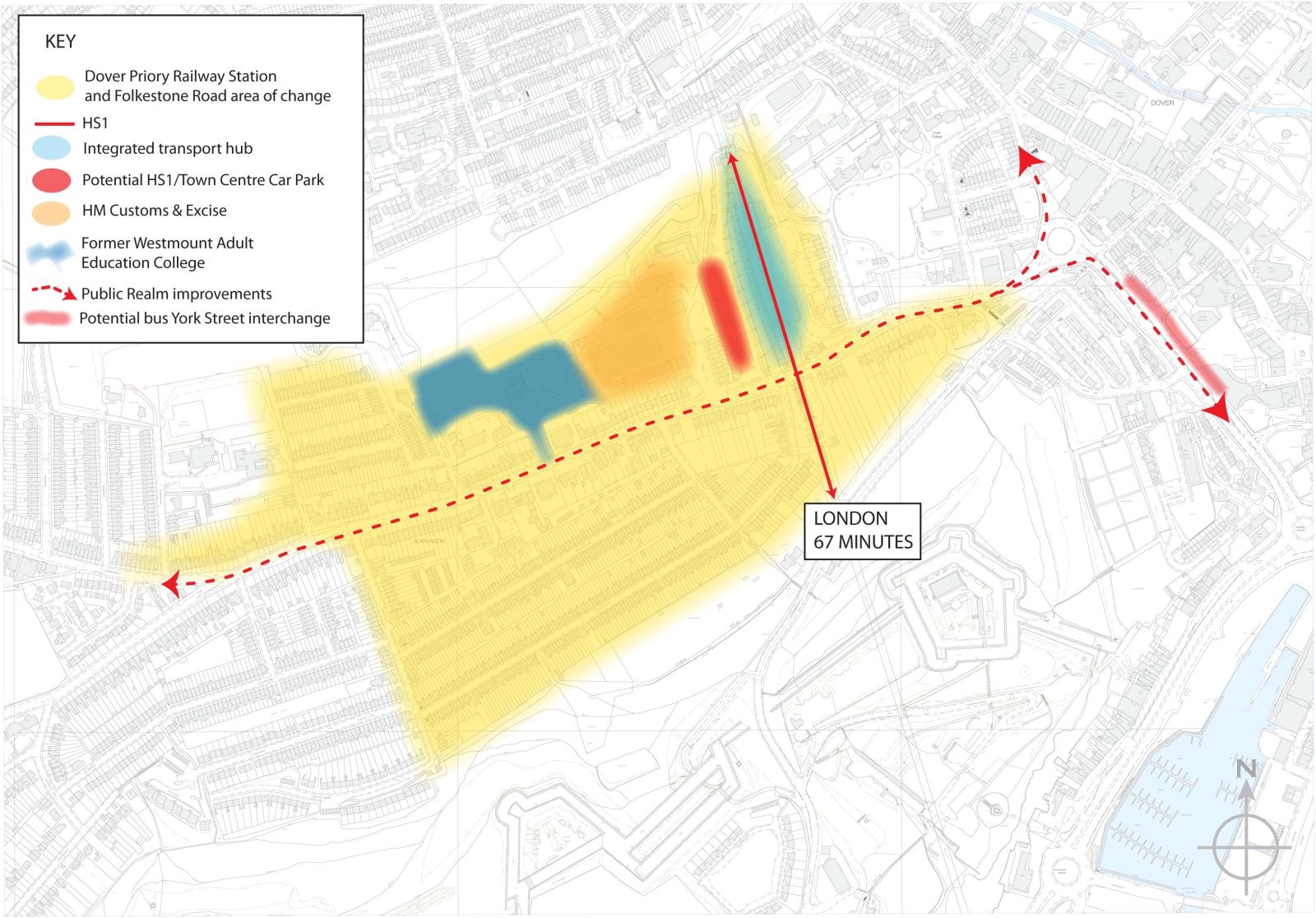
Western Heights
3.138
Visitor circulation between the components of the Western Heights fortifications and links to the town are currently impeded in many instances. In order to assist with this it would require the removal of vegetation from ditches and the main fortifications. This would enable visitors to the Western Heights to enjoy and walk along the bottoms of the defensive ditches. It would also facilitate legibility of the historic military circulation routes around the site and the defensive principles that informed the development of these important fortifications to be more fully understood and enhanced. The removal of vegetation from the Heights' southern slopes and returning them to chalk grassland as part of a co-ordinated land management strategy for nature conservation that would improve the legibility of fortifications. Care would, however, need to be taken to ensure that any measures to control grazing animals (e.g. temporary fences) do not damage significant remains or detract from the setting of the defences.
Broad Objectives:
-
Produce a Master Plan and vision for the long-term future of the Western Heights;
-
Promote awareness and understanding of the Fort in conjunction with the other heritage assets in Dover through public and voluntary partnerships to coordinate management and to devise a programme of improvements and seek funding;
-
Promote the Fort as part of a package of defence themed visitor attractions;
-
Use the historic character of the place to inform any future development and create a sense of place;
-
Investigate development proposals, particularly those which support tourism and encourage additional visitors, that help to secure a long term sustainable future for the Fort;
-
Ensure that any development proposals are informed by the significance of the Monument and its component parts;
-
Wherever possible, new and sustainable uses should be found for the existing heritage assets in order to ensure their long-term future;
-
Support proposals that increase the significance of this Scheduled Monument and the internal relationships between the component parts of the Monument and their setting;
-
Encourage greater public access to and interpretation of the Monument;
-
Retain the openness of the interior of the Scheduled Monument, particularly between the two Forts, which is an essential part of its character, and as such should be retained;
-
Support a co-ordinated land management strategy for the slopes of the Heights in order to improve the interpretation of the fortifications;
-
Investigate and identify sufficient and suitable access, parking and sustainable transport arrangements; and
-
Investigate and propose means of improving the wildlife value of the open areas within the Fort, and improve their connectivity with the wider Green Infrastructure network.
Policy LA11 – Dover Western Heights
The Council will establish a comprehensive framework for the conservation management of the Dover Western Heights Fortifications Scheduled Monument and Conservation Area. The framework will take the form of a masterplan to be adopted as a Supplementary Planning document. The masterplan will:
-
be produced in liaison with landowners, residents, organisations and individuals with an interest in the area, and the public;
-
establish a shared vision for the future of the fortification that preserves and enhances its significance as heritage asset and its landscape and ecological value, whilst securing a sustainable future;
-
identify management initiatives, including any opportunities for development or changes of use that would enhance the public's enjoyment and understanding, that would help realise the vision.
-
provide guidance for determining planning and related applications that affect the fortification; and
-
provide a basis for future governance of the fortification, including consideration of funding opportunities.
view map
To see this policy on the interactive map, click
here
To read the full document, click here (Opens a PDF in a new window)
North Town
3.139
The Dover Masterplan (2006) identified an area it called North Town, which is situated to the north of Park Street, as a key interface between High Street, Bridge Street and Salisbury Road. The Masterplan concluded that this area offered a number of regeneration opportunities as it is also provides a link between St.Radigund's and the town centre.
3.140
North Town includes the Castleton Retail Park (which is occupied by a number of convenience stores), Charlton Shopping Centre and a multi-storey car park. There is a
pedestrian link from the Castleton Retail Park to the town centre via the multi-storey car park and the Charlton Shopping Centre although it would benefit from being improved. The River Dour is largely hidden from view as it flows underneath the car parking area for the Castleton Retail Park and to the side of the multi-storey car park.
3.141
The focus of this Area of Change is to 'Create and Restore' through strengthening the existing character and the creation of an improved urban environment. Whilst it is unlikely
that the Castleton Retail Park will be redeveloped within the Plan period, if any sites do come forward for redevelopment opportunities should be taken to create walking and cycling routes along the river, restore the river frontage and its setting. Any redevelopment of existing buildings offers the opportunity to improve the poor quality pedestrian route between the Castleton Retail Park and the Charlton Shopping Centre which is located on the High Street.
Broad Objectives:
-
Improve the general quality and overall design of this part of Dover;
-
Support proposals that make a positive contribution and restore the river frontage and its setting;
-
Explore opportunities when sites become available for redevelopment to create public and cycle access to and along the River Dour; and
-
Improve and upgrade the poor quality pedestrian links from North Town to the town centre.
Dover Leisure Centre
3.142
Dover Leisure Centre occupies a particularly prominent site located on the corner of Townwall Street (part of the A20 trunk road from the Port) and Woolcomber Street, near the base of the cliffs. Facilities on offer at the Leisure centre include a swimming pool, squash courts, fitness suite, dance studio and a multi-purpose sports hall. The building dates back to the 1970s and despite significant investment by the District Council the sports facilities do not meet current expectations. In addition, the Leisure Centre is not energy
efficient and therefore is very expensive to run.
3.143
In order to deliver the growth aspirations set out in the Core Strategy Policy CP6 identifies a number of infrastructure requirements including replacement of Dover Leisure Centre. Recent assessments of the District's swimming pool and indoor sports hall provision using the Sport England Facilities Planning Model demonstrated that existing facilities are operating close to full capacity in the Dover urban area. Pressure on these types of facilities will increase during the Plan period due to increased demand, particularly with respect to swimming pool provision. Improved facilities could form part of the planned regeneration of the town and meet the predicted increase in demand.
3.144
The focus for this Area of Change is to 'Create and Restore'. Given that the existing building is near the end of its useful life, an opportunity exists to create a landmark building. Leisure facilities could be located at a different site, so long as it is equally accessible to residents. If upgraded leisure facilities are provided at a new location, a range of uses could be considered at this prominent site. The forthcoming Sports and Recreation Strategy will include a detailed discussion of possible options for meeting predicted demand.
Broad Objectives:
-
Investigate whether it will be possible to meet the need for modern, inclusive sport and recreation facilities by building new facilities on the existing site, or whether the Leisure Centre should be relocated and the site redeveloped; and
-
Ensure that any new development on the site fulfils the potential of this prominent location.
3.2 Deal
3.145
The Adopted Core Strategy identifies Deal as a District Centre, the ‘Secondary focus for development in the District; suitable for urban scale development’. The Deal urban area comprises urban wards and the built-up parts of the parishes of Walmer, Sholden and Great Mongeham, which form a continuous built-up area.
3.146
The northern part of the town is low lying flat land which has been identified as being within high risk flood zones. There are also European nature conservation designations (Ramsar, Special Protection Area and Special Area of Conservation) to the north of Deal.
3.147
The town has 14,500 dwellings (12) and a population of 30,085 (Deal and Walmer wards)(13). The town has a wide selection of services including a range of shops, primary and secondary schools and a number of medical facilities including a local hospital. It is also served by a mainline railway and a high speed train service to London which operates at peak times.
(12) 2011 Census - Table QS418EW
(13) 2011 Census - Table QS103EW
Urban Grain and Structure
3.148
Deal originated as a series of villages, Walmer, Upper Deal (now on the boundary of Middle Deal/Sholden and Mill Hill Wards), Sholden and Great Mongeham, with Sholden, Great Mongeham and Upper Walmer positioned on higher ground. Deal started to expand when it became one of the great maritime towns in England in the seventeenth and eighteenth
centuries and then again when development of the nearby Kent Coalfield started in the early twentieth century.
3.149
The pattern of roads and tracks linking the settlements on the downs with the coastal settlements of Deal and Lower Walmer is determined by topography. They run parallel or at right angles to the slopes and ridges at about a 40 degree angle to the coast. The town itself is characterised by a generally tightly grained built form with narrow streets, which
follow the direction of the coastline and are aligned in parallel or right angles to the sea. The railway line was constructed in the area where the two urban grids intersected. Connection between the grids across the tracks are limited. As a consequence, development in North Deal today feels isolated from the wider town.
3.150
Development in Deal today is continuous, although Great Mongeham and Sholden still retain their 'village feel'. Latter day expansion of Deal has predominantly taken place on the high grounds to the south of the old town. Historically development in North Deal has taken place incrementally over the years and has been limited due to flood and access constraints.
Core Strategy
3.151
The Core Strategy has identified Deal as the secondary focus for development in the District. The issues raised in the Strategy include:
-
The need for improved community facilities in North and Middle Deal;
-
Limited supply of previously developed land; and
-
The identification of three broad areas for urban extension.
3.152
The Strategy aims to retain and develop the town's popular appeal as a place to live while improving local employment opportunities and to reduce the need to travel.
Provision of Infrastructure
3.153
An integral part of the Core Strategy is to ensure that development proposals are supported by the timely provision of an appropriate level of infrastructure (such as affordable housing, open spaces or highways). This is reflected in Policy CP6. The infrastructure identified in the Core Strategy specifically for Deal included:
-
A new secondary school to modernise and improve the standards;
-
A nursery school to address a shortfall in North Deal;
-
GP facility in North Deal;
-
General community facility in North Deal;
-
Multi-use community facility to serve Middle Deal;
-
Indoor court tennis facilities at Deal; and
-
Skate and BMX park.
3.154
Since the adoption of the Core Strategy many of the infrastructure requirements have been met. A new GP facility and community building in North Deal was completed in 2011 as part of the Golf Road/Cannon Street development. The new GP surgery meets the demand for such a facility in this area and the community centre is a valuable community asset providing space for a variety of activities for the general public. In addition to the new GP surgery in North Deal, another surgery was opened in St Richards Road, in the southern part of Deal, replacing the one in Deal town centre.
3.155
The requirement for a new nursery school in North Deal was met through the granting of a permanent planning permission at Western Road and full permission for one at Stanhope Road. A four court indoor tennis centre was opened on land adjacent to the Tides Leisure Centre which was jointly funded by Dover District Council and British Tennis. This new facility offers a complete programme of junior tennis coaching and playing opportunities. A skate and BMX park has also been built adjacent to the leisure centre.
3.156
A new flood defence scheme along the coast will provide a 1 in 300 standard of protection to 1,418 homes and 148 commercial properties in Deal.
3.157
Most of the identified infrastructure requirements have therefore been met and only two are still outstanding, a secondary school and multi-use community facility. It is unlikely that a new secondary school will be provided. Two schools have been merged in Deal and Walmer because a falling number of pupils would not sustain two schools. The multi-use community facility to serve Middle Deal could, if it is demonstrated to be financially viable and an operator is identified, come forward as part of the development proposals.
Housing Allocations
3.158
The Core Strategy housing allocation for Deal is 1,600 dwellings and this is geared around meeting local rather than strategic needs. The proposed housing numbers would ensure that the population remains at the same level to support 2006 levels in the face of a continuing tend of falling household size, but will not address the issues regarding the ageing of the population.
3.159
There are, however, limited opportunities for further development in the town. This is primarily due to the limited supply of previously developed land (the majority of this has
already been developed); there are access difficulties; and a large area encompassing the northern part of the urban area has been identified within Flood Zones 2 and 3.
3.160
Within these limitations, the Core Strategy identified three broad areas for urban extension. These are located on the north side of Deal, in Sholden and to the south of Deal in Walmer. Both of the sites in Sholden have the benefit of planning permission in 2012. To meet the remaining requirement three smaller sites in Deal have also been allocated (see Policy LA15).
Allocations
3.161
Six sites have been identified for residential development and these will provide approximately 800 (14) dwellings. The allocated sites are identified on the diagrammatic plan
below.
(14)The discrepancy between this figure and the figure contained in Table 3.1 of 570 is attributable to land north west of Sholden which is currently under construction and is therefore counted within 'Sites identified through planning applications' in Table 3.1
3.162
The allocated sites, together with sites identified through completed and unimplemented planning permissions (see Table 3.1), leave a residual of approximately 100 dwellings to be identified to meet the Core Strategy requirement. To meet this residual the District Council would have to consider sites that have scored poorly in terms of flood risk, landscape impact or access. A 'windfall' allowance has been included for the later part of the Plan. Residential development in Deal has, over a five year period ( 2008 to 2013), had an average annual ‘windfall’ completion rate of 50 dwellings. These will not be considered in the phasing before 2018. The Core Strategy identifies, in Policy CP3, that the housing figure for Deal could be revised upwards subject to the investigation of the Middle/North Deal area.
Land to the North West of Sholden New Road
Site Location and Characteristics
3.163
The 6.67ha site is located on the north western edge of Sholden on the east side of the A258 Deal to Sandwich Road. It consists of agricultural land with an unmade access
for agricultural vehicles at the western corner of the site. The site falls gently to the north and is framed on three sides by mature trees. The trees are protected by Tree Preservation
Orders and consist of a mixture of evergreen trees to the north east, an avenue of mature Beech Trees along Sholden New Road to the south east, and a deciduous tree belt along
the north western boundary, which adjoins a private unmade track serving Cottington Lakes Fishery. This provides screening between the site and open farmland. The site boundary with the A258 is partially screened by a hedge.
Site Context
3.164
The site has been identified as a broad area for urban extension in the Core Strategy and full planning permission has been granted (in 2012) for 230 dwellings. The overall
character of the site is an area of rural transition from urban to open countryside and the surrounding uses reflect this with open countryside to the south west and north west and residential properties to the north east and south east. There are a number of listed properties at Hull Place, to the north east of the site. A tree belt along the north eastern boundary
provides a strong visual screen between the site and the properties at Hull Place. European designated nature conservation sites (SAC, SPA & Ramsar) and an area at risk of flooding (Flood Zones 2 & 3) lie to the north.
3.165
A public footway runs parallel with the sites north eastern boundary and the site is in close proximity to public footways which provide good access to routes to the open countryside and the Fowlmead Country Park. A segregated cycle way is located to the west and this runs parallel with the A258, connecting the site with Fowlmead Country Park and
Betteshanger employment site further to the north west.
Proposed Development
3.166
The site needs to be developed in a way that provides a transition from urban area of Sholden/Deal to the open countryside and retain a 'soft edge' to the development. The
western corner of the site is in a prominent location on the A258 coming into Sholden/Deal and should consist of landscaping. This makes it appropriate and necessary to the reduce density and create a looser grain to the the development along the frontage from the western corner of the site and use landscaping to address the site's location on the edge of the existing built up area.
3.167
Proposals need to pay particular attention to the retention and safeguarding of the mature trees that frame the site. To safeguard the trees from any future pressure for removal,
development should be set back by 20m. The approach towards the design and layout of the site should also consider the relationship of the development with local heritage assets, particularly the listed buildings located to the north of the site. The tree belt along the north eastern edge should be strengthened through additional planting to ensure that any detrimental impact on the listed buildings is reduced.
3.168
The vehicular access to the site should be from the A258 and measures provided to mitigate against impacts on the wider road network. Measures to encourage cycling, use of buses and walking should be an integral part of the proposals. The foul sewerage system may also need to be upgraded.
3.169
A combination of the scale of the development and the proximity of the site to European designated nature conservation sites means that any planning application will have to develop a strategy with a range of measures and initiatives such as the provision of informal open space or walking routes (leading to wider PROWs) within the development and improved access to Fowlmead Country Park.
3.170
Overall the size of the site and its location on the edge of the countryside lends itself to a range of dwellings that would improve the housing offer in Deal. The western corner of the site would would be suitable for lower density, larger family housing whilst other parts of the site could provided higher density smaller dwellings. The capacity of the site, 230 dwellings, is informed by the permitted planning application.
Policy LA12 – Land to the North West of Sholden New Road
The site is allocated for residential development with an estimated capacity of 230 dwellings. Planning permission will be permitted provided that:
-
the transition of the countryside is retained by ensuring that the western corner of the site consists of landscaping and development is of a low density and looser grain along the frontage with the A258;
-
existing trees are retained and enhanced through additional planting with a 20m safeguarding boundary provided, unless removal is essential for access;
-
a mitigation strategy to address any impact on the Thanet Coast and Sandwich Bay Ramsar and SPA sites and Sandwich Bay SAC site is developed. The strategy should consider a range of measures and initiatives;
-
the development should provide a connection to the sewerage system at the nearest point of adequate capacity; and
-
vehicular access is achieved from the A258 and measures provided to mitigate against impacts on the wider road network.
view map
To see this policy on the interactive map, click
here
To read the full document, click here (Opens a PDF in a new window)
Land between Deal and Sholden
Site Location and Characteristics
3.171
The 15 ha, irregular shaped site is located on open land separating Middle Deal and Sholden. The site consists predominantly of agricultural land, scrub, trees and hedgerows
along field boundaries. The land falls gently from the south to the north. There are numerous pedestrian access points onto the site but the main vehicular access is from Hyton Drive. Southern Water has advised that multiple sewers cross this site.
Site Context
3.172
The site has been identified as a broad area for an urban extension in the Core Strategy and has been the subject of Masterplanning and stakeholder involvement in 2006.
The site has also been subject to an outline planning application which, in 2011, the District Council resolved to grant. The surrounding uses reflect the site's location on the edge of the town and consists of agricultural fields to the north and west, business uses to the north east (Southwall Road area) and residential areas to the east and south. This site separates the existing built up area of Deal and Sholden. Access to London Road is via existing residential roads which are tightly constrained.
3.173
The eastern part of the site is within Flood Zones 2 and 3 and there are European nature conservation designations to the north east.
Proposed Development
3.174
Proposals for development need to be informed by the constraints on the site, most notably flood risk (Flood Zones 2 and 3 are on the eastern part of the site), landscape and
access. The line of the site boundary reflects that of the planning application, which was identified through a flood risk sequential analysis within the site. Due to the low lying nature of this area, surface water management and flood attenuation will also be required.
3.175
The Heritage Strategy has identified five 'Themes' that should be considered as part of any proposal. The Themes are 'Coastal Processes and Landscape', 'Listed Buildings',
'Archaeology', 'Church', 'Settlement' and 'Farmsteads' and these should be considered as part of any application. The main issues are that the site provides short views of Sholden and St Nicholas's Church and long uninterrupted views of the coast.
3.176
Land to the west of the site, currently in agricultural use must also be retained to ensure that there is separation between the settlements of Sholden and Deal. An integral part of the design of any proposed development is that it creates a soft edge with the surrounding countryside.
3.177
The nature of the local road network indicates that measures will have to beinvestigated to mitigate the transport impacts of the new development. This should include supporting alternative modes of transport to the car, such as the provision of new bus routes and cycle ways. The Core Strategy identified the need for a multi-use community facility to serve the Middle Deal area. If it can be demonstrated to be financially viable and an operator
could be identified this should form part of the development proposal(15).
3.178
Early discussions should take place with Southern Water regarding the sewers that cross the site and these would need to be taken into account as part of any planning application.
3.179
A combination of the scale of the development and the proximity of the site to European designated nature conservation sites means that any planning application will have to develop a strategy with a range of measures and initiatives such as the provision of informal open space or walking routes (leading to wider PROWs) within the development.
3.180
The overall size of the site and its location on the edge of the countryside provides the opportunity to offer a range of dwellings that would improve the housing offer in Deal. These could range from lower density, larger family homes to higher density, smaller units. The starting point for any proposal would be the mix identified in the SHMA.
Policy LA13 – Land between Deal and Sholden
The site is allocated for residential development with an estimated capacity of 230 dwellings. Planning permission will be permitted provided that:
-
the design of the site creates a soft edge between the proposed development and the surrounding countryside and St Nicholas's Church;
-
views of St Nicholas's Church and the wider landscape are incorporated into any design and retained;
-
community facilities are provided to benefit existing and new residents in the area;
-
a mitigation strategy to address any impact on the Thanet Coast and Sandwich Bay Ramsar and SPA sites and Sandwich Bay SAC site is developed. The strategy should consider a range of measures and initiatives;
-
the development should provide a connection to the sewerage system at the nearest point of adequate capacity and ensure future access to the existing sewerage infrastructure for maintenance and upsizing purposes;
-
footways are preserved, and where necessary enhanced and integrated into the development; and
-
measures provided to mitigate against impacts on the wider road network including sustainable transport measures.
view map
To see this policy on the interactive map, click
here
To read the full document, click here (Opens a PDF in a new window)
Land between 51 and 77 Station Road, Walmer, Deal
Site Location and Characteristics
3.181
The almost 9 ha site is located on the southern edge of Walmer. It consists primarily of agricultural land fronting Station Road and a small area of undeveloped land to the west of Mayers Road. The majority of the boundary consists of hedgerow although currently there is not a physical boundary to the south western edge of the site. The land falls gently to the north towards Station Road. Telephone lines and public rights of way cross the site (ED36 and ED58). There is currently no vehicular access onto the site. Southern Water has advised that two water mains cross this site.
Site Context
3.182
The site has been identified as a broad area for urban extension in the Core Strategy. The site lies on the edge of the built form and this is reflected in the surrounding uses, which consist of a mix and range of different styles, types and ages of residential properties to the north, east and north west. There are residential properties on either side of the site fronting Station Road. There is a caravan holiday park to the south east and open countryside to the south and south west.
3.183
Station Road fronts the site and this leads directly to Dover Road (A258). The junction of these two roads is busy at peak times of the day. The site is visible from the Dover Road (A258) but is set against the existing urban form and there are views from within the site to the south towards Ripple Windmill. The Sandwich/Dover railway line runs to the west of the site.
Proposed Development
3.184
The design of the proposed development should be guided by its location on the edge of the countryside and an integral part of the proposed development will be to create a soft edge to the urban form.
3.185
In order to avoid a detrimental impact on the wider landscape, development would have to be carried out in conjunction with structural and open space landscaping to create a new south western boundary line. This is to reduce the visual impact in the wider landscape and help to create a new rural-urban transition. This should be approximately 15m in width and comprise native species. There would also need to be a landscape buffer between the proposed development and the neighbouring caravan park located to the east. These areas can also be used for SUDs and informal recreation.
3.186
Development proposals should be arranged to include frontage development along Station Road based on an informal layout, taking into account long distance views to Ripple Windmill, and include a range and mix of housing styles with a variety of roof pitches. Care should be taken with the design of the dwellings so that they do not overpower neighbouring properties on Mayers Road or John Tapping Close and do not appear prominent when viewed from the A258.
3.187
The site falls outside of the catchment of existing play space as set out in the Review of Play Area Provision 2012-2026 (March 2012). The site is of sufficient size to provide a play space which needs to be incorporated into the overall design and the layout of the development. This should be in accordance with the Council's Play Area Standards set out in Annex 1 of the full PDF document.
3.188
With regard to vehicular access, this should be from Station Road. Development proposals will also have to undertake a traffic impact assessment to establish whether any off site road improvements will need to be undertaken, in particular at the Station Road and the A258 Junction. Development at this scale would require a secondary road/emergency access and this could be established, with a defined turning head, from the south western end of Mayers Road. Mayers Road would not suitable for any other vehicular access points
to the site. There are also a number of footways that cross the site, which should be retained, enhanced and incorporated in any proposed development.
3.189
Early discussions should take place with Southern Water regarding the two water mains that cross the site and these would need to be taken into account as part of any planning application.
3.190
A combination of the scale of the development and the proximity of the site to European designated nature conservation sites means that any planning application will have to develop a strategy with a range of measures and initiatives such as the provision of informal open space or walking routes (leading to wider PROWs) within the development.
3.191
The size of the site and its location on the edge of the countryside means that it has a particular role in providing a range of dwellings that would improve the housing offer in this part of Deal. These could range from lower density, larger family homes to higher density, smaller units.
Policy LA14 – Land between 51 and 77 Station Road, Walmer, Deal
The site is allocated for residential development with an estimated capacity of 220 dwellings. Planning permission will be permitted provided that:
-
the south western and eastern edges of the development creates a landscaped boundary with the adjacent rural area, incorporating structural and open space landscaping features;
-
the design incorporates frontage development along Station Road where it is not required for the access road;
-
long views of Ripple Windmill and the wider countryside are retained and incorporated into the layout;
-
footways are preserved, enhanced and integrated into the development;
-
play space is provided in accordance with the Council's Play Area Standards;
-
the landscaping throughout the site would improve biodiversity value;
-
a mitigation strategy to address any impact on the Thanet Coast and Sandwich Bay Ramsar and SPA sites and Sandwich Bay SAC site is developed. The strategy should consider a range of measures and initiatives;
-
the development should provide a connection to the sewerage system at the nearest point of adequate capacity and ensure future access to the existing sewerage infrastructure for maintenance and upsizing purposes;
-
the main vehicular access is onto Station Road with an emergency vehicular access from Mayers Road; and
-
measures provided to mitigate against impacts on the wider road network.
view map
To see this policy on the interactive map, click
here
To read the full document, click here (Opens a PDF in a new window)
Residential Allocations
3.192
The following sites are allocated for residential development or are a change to settlement confines that may enable development but do not warrant a site specific policy. The acceptability of any planning application proposals will be judged against general Development Plan policies and all other material considerations.
Policy LA15 – Residential Development
|
Land Allocated for Residential Development at Deal |
|
|
Site
|
Design Guidelines
|
Approx. no. of dwellings
|
Issues
|
|
Stalco Engineering Mongeham Road |
Mix of housing type and density. Higher density adjacent to the existing built form, progressively reducing north westwards towards the boundary with the open countryside. |
36 |
Comprehensive development;
Flood Risk;
Conservation Area; Close to European Nature Conservation Designation;
Waste Water pumping station and connection to the sewerage system at nearest point of adequate capacity.
|
|
Land to the rear of 133-147, St Richards Road |
Mix of housing type and density. Higher density adjacent to the existing built form, progressively reducing south westwards towards the boundary with the open countryside. |
40 |
Creation of 15m wide planted landscape buffer to the south west to protect views from Ellens Road and to enhance biodiversity |
|
Former Deal County Primary School |
Urban location that lends itself to higher density development reflecting the neighbouring residential built form. The site has full planning permission and in 2014 was under construction. |
44 |
Open Space provided; Bat survey undertaken; Access is from Mill Road; Frontage development along Mill Road and the footway to the cemetery; Sewers |
view map
To see this policy on the interactive map, click
here
To read the full document, click here (Opens a PDF in a new window)
Town Centre Boundary
3.193
The Retail Update (2012) shows that Sainsburys on West Street plays an important role in terms of retaining expenditure within the local area. The town centre boundary has therefore been amended to include this area as it functions as part of the town centre and to reflect the recommendations made within the Retail Update.
Albert Road, Deal
3.194
Paragraph 3.67 of the Council’s Adopted Core Strategy highlighted that there may be the potential for further development in the Middle and North Deal area.
3.195
Further investigation, in the form of the Deal Study, has narrowed down the focus of the investigation on the area between Albert Road and Southwall Road. The Study indicates that there may be the opportunity to create a new road from Albert Road to Southwall Road, which would help to relieve traffic in Southwall Road. If it can be demonstrated that there is such potential, the mix of uses, including the suitability of retail and residential development, the new road, other associated traffic improvements and compatibility with flood risk policy can be advanced through a planning application.
The development of Albert Road, Deal for B1 and B2 employment uses is covered by Saved Local Plan Policy LE5.
Betteshanger Colliery Pithead
The development of Betteshanger Colliery Pithead for B1, B2 and B8 employment uses is covered by Saved Local Plan Policy AS1
3.3 Sandwich
3.196
Sandwich is a historic Cinque Port and market town on the River Stour, located in the north eastern part of the District. Sandwich is renowned for its medieval street pattern and high concentration of Listed Buildings. It is, however, located in a low lying landscape which has been identified as being within high risk of flooding. There are also European nature conservation designations (Ramsar, Special Protection Areas and Special Areas of Conservation) to the north and east of Sandwich.
3.197
The parish of Sandwich has a population of 4,985 (16) and approximately 2,528 dwellings (17). To the north of the town there is a major business area leading up to and including Richborough.
(16) 2011 Census Table QS103EW
(17) 2011 Census Table QS103EW
3.198
Sandwich serves the daily needs of the town itself and neighbouring villages and has a wide selection of services including a range of shops, primary and secondary schools and medical facilities. The town is also served by a mainline railway with a high speed train service to London operating at peak times. The principal A256 route from Dover to Thanet has recently been upgraded to a dual carriageway through the East Kent Access programme. To the north of the town is Discovery Park Enterprise Zone.
3.199
An international golf course, Royal St. George's Golf Club, which has hosted the British Open Championship, lies to the immediate east of the town. A second golf course, Princes Golf Course, lies to the north east. Both are important contributors to the local economy and profile of the area. The Core Strategy has identified Sandwich as a 'Rural Service Centre' the main focus for development in the rural area, suitable for a scale of development that would reinforce its role as a provider of services to a wide rural area.
Urban Grain and Structure
3.200
The medieval origins are clearly seen in the tightly knit street pattern and built form within the remains of the town wall; a Scheduled Monument. Outside of the town wall, to the south and west, the street pattern becomes looser, reflecting latter day developments. The River Stour has, historically, limited development to the north and it is only since the 1980s that residential development has taken place in that area. Further north is the Discovery Park Enterprise Zone which was occupied by a large pharmaceutical complex (see paragraph 3.14). The site was developed gradually since the 1950s and is particularly visible from A256 and the north of Sandwich. Beyond the Enterprise Zone is a business area which has developed along the A256 (Ramsgate Road).
Employment
3.201
The Core Strategy identified that the area north of Sandwich should be promoted for a wide range of uses to support jobs. The Discovery Park Enterprise Zone comprises of high quality Research and Development buildings. The Richborough area, which is north of the Enterprise Zone, comprises smaller-scale industry and brownfield land suitable for commercial redevelopment. This area, which is close to the boundary of Thanet District, has become a focus for waste treatment, renewable and low carbon energy industries.
3.202
Richborough Power Station and the former landfill site (which consists of raised land) and adjoining low grade agricultural land to the west between the River Stour and the railway line, provides a potential location for such facilities, as well as a connection to the National Grid . The Council has approved applications for a Solar Farm, Peaking Plant Facility, and site-wide infrastructure to facilitate the creation of a green energy park. The Council, in liaison with Thanet District Council and Kent County Council (as the Minerals and Waste Authority) will continue to explore, with the promoters of any schemes, whether this potential can be realised. Particular regard would need to be had to environmental, transport and wildlife impacts together with visual impact on landscape and on the gateway location to and from Thanet.
3.203
The Kent Minerals and Waste Local Plan (which includes the Waste Sites Plan and Minerals Sites Plan published in May 2012) identifies this area as a location for energy from waste, green waste treatment and material recycling facilities. Development proposals in this area should also refer to these Plans and the relevant National Planning Statements.
Core Strategy
3.204
The Settlement Hierarchy set out in the Core Strategy identified that the town is the main focus for development in the rural area. The main issues raised in the Core Strategy are that:
-
there is evidence that the centre is losing vibrancy;
-
there is a need for improved coach parking facilities;
-
some affordable housing will have to be met at Dover or Deal, where there is more opportunity for development;
-
the Richborough business area should be promoted for a wide range of uses that would support jobs growth and the research and development functions across the business and education sectors.
3.205
The Core Strategy states that development should reflect the existing character whilst taking opportunities to improve design standards. The potential for previously developed sites in the town and undeveloped sites on the edge of the town are limited. The town is subject to a number of constraints to development including the narrow road network
of the medieval core, the high concentration of historic assets and flood risk. The areas at risk from flooding will be improved with a planned new flood defence scheme, which is
anticipated to be completed in 2015. Overall, there are few locations where development could take place without any of these constraints. The Core Strategy has identified a broad
location for urban extension on land on the south western edge of the town.
Provision of Infrastructure
3.206
An integral part of the Strategy is to ensure that development proposals are supported by the timely provision of an appropriate level of infrastructure (such as affordable housing,
open spaces, highways). This is reflected in Policy CP6. The Core Strategy identifies two specific requirements:
3.207
The Sandwich town tidal defence scheme will be completed in 2015 and will reduce the risk of tidal flooding to Sandwich and Stonar Loop.
Housing Allocations
3.208
The local housing market is strong at Sandwich with high demand and average house prices remaining relatively high across the area since 2001.
3.209
The Core Strategy housing allocation for Sandwich is 500 dwellings. After taking account of sites identified through completed and unimplemented planning permissions (see
Table 3.1), there is a residual of 230 dwellings to allocate. The housing provision for Sandwich is geared around meeting local rather than strategic need and will ensure that the population remains static. This will remedy the continuing trend of falling household size, but will not address the issues regarding the ageing of the population. Any development should reinforce but not change the area's housing offer and should reflect the existing character while taking opportunities to improve design standards.
Housing Sites
3.210
Although Sandwich is constrained by Flood Zones 2 and 3, revised Environment Agency mapping shows reduced risk, particularly to the south. Two sites have been identified for future development that are within the sequentially preferable Flood Zone 1. The allocated sites are identified on the diagrammatic plan below.
Land to the west of St Bart's Road, Sandwich
Site Location and Characteristics
3.211
The 5.2 ha site is located on the western edge of Sandwich and consists primarily of flat open agricultural land but also includes a dwelling that fronts Woodnesborough Road.
The dwelling is enclosed behind an established hedgerow. Existing vehicular access on to the site is from Woodnesborough Road to the north west and St Bart's Road to the north east. A byway (ES10) crosses the site from the east to the west. A bridleway (ES8) runs along the south western boundary. Southern Water has advised that a water main crosses this site and that there is insufficient sewerage capacity directly available to serve this site.
Site Context
3.212
The site lies on the edge of the town's built area. There is residential development to the north and open farmland to the south. Allotments lie between the residential properties to the north and the site. Sandwich Junior School lies further to the south east.
3.213
As the site is close to European designated nature conservation sites, it is within 2 km, there could be in combination recreational impacts with other development sites in the
District (please see Mitigation Strategy in Annex 1 of the full PDF document).
Proposed Development
3.214
Any planning application should be sympathetic to the transitional context of the location on the rural fringe. It is considered that development in this area would not have
an unduly detrimental impact on the wider landscape but the transition from the town to the countryside is an important consideration in any design. In order to provide this, any
application should include landscaping along the south western and south eastern boundaries and retain any existing hedgerows and vegetation. The landscaping should be an intermittent mixture of trees and hedging, providing glimpses of development, and provide a suitable transition to the countryside.
3.215
Whilst the size of the site would be capable of accommodating a greater number of dwellings the scale of development has been limited to 120 dwellings due to highway limitations. Vehicular access to the site should be from a single access onto Woodnesborough Road to the north of the site with an emergency access from St Bart's Road.
3.216
Black Lane, a byway (ES10) which crosses the site, should be retained and enhanced as part of any development except where access to the eastern part of the site is required to cross it. The bridleway (ES8) to the south east will also have to be retained and enhanced as part of any development.
3.217
The design and layout of the proposed development will need to address the relationship of Black Lane and the allotments.
3.218
The statutory allotments, which are protected under Policy DM25, have been excluded from the area of land that has been allocated for housing development because they provide a valuable community use.
3.219
A combination of the scale of the development and the proximity of the site to European designated nature conservation sites means that any planning application will have to develop a strategy with a range of measures and initiatives such as the provision of informal open space or walking routes (leading to wider PROWs) within the development.
3.220
Early discussions should take place with Southern Water regarding connection to the wider sewerage system and the water main that crosses the site, which would need to be taken into account in the layout proposals of any planning application.
3.221
As the site is in multiple ownership it should be planned comprehensively. If it is implemented incrementally, each stage must demonstrate that it will not prejudice the implementation of the remainder.
3.222
The overall size of the site and its location on the edge of the countryside provide the opportunity to offer a range of dwellings that would improve the housing offer in Sandwich. These could range from lower density, larger family homes to higher density, smaller units. The starting point for any proposal would be the mix identified in the SHMA.
Policy LA16 – Land to the west of St Bart's Road, Sandwich
The site is allocated for residential development with an estimated capacity of 120 dwellings. Planning permission will be permitted provided that:
-
development proposals are sensitive to the adjacent rural landscape and reflect the spatial and rural characteristics of adjacent landforms and development;
-
there is a comprehensive approach to development of the whole site;
-
a mitigation strategy to address any impact on the Thanet Coast and Sandwich Bay Ramsar and SPA sites and Sandwich Bay SAC site is developed. The strategy should consider a range of measures and initiatives;
-
the Byway (ES10) , which crosses the site, should be retained and enhanced as part of any development except where access to the eastern part of the site is required to cross it. The bridleway (ES8) is retained and enhanced.
-
development should provide a connection to the sewerage system at the nearest point of adequate capacity and ensure future access to the existing water supply infrastructure for maintenance and upsizing purposes;
-
intermittent landscaping, providing glimpses of development behind, is provided along the south western and south eastern boundaries in order to provide a suitable transition to the countryside;
-
existing boundary hedgerows and vegetation are retained;
-
the design and layout of the proposed development addresses the relationship of Black Lane and the allotments; and
-
vehicular access to the site is from Woodnesborough Road with an emergency access from St Bart's Road.
view map
To see this policy on the interactive map, click
here
To read the full document, click here (Opens a PDF in a new window)
Land adjacent to the Sandwich Technology School, Deal Road
Site Location and Characteristics
3.223
This 3.47 ha, irregular shaped site is located on the southern edge of the town. It consists of a flat agricultural field and associated farm buildings, with an established hedgerow
around the boundary. An irrigation main runs across the site from Dover Road to Deal Road. The existing vehicular access is from Dover Road. Southern Water has advised there is insufficient sewerage (underground) capacity directly available to serve this site.
Site Context
3.224
The site is located on Deal Road, which is one of the main routes into Sandwich. The site is on the edge of the town and the surrounding uses reflect this rural/urban transition. Sandwich Technology School is to the west of the site and there are residential dwellings, fronting Dover Road, along the northern boundary and to the north east. Sandwich Sports
and Leisure Centre is located within the school grounds, adjacent to the boundary to the site. There is a farm shop to the east and open countryside to the south east. There are
three listed buildings located on Dover Road and the boundary of these properties abut the site. Kent County Council Highways has indicated that Dover Road is not suitable to serve any further large scale development due to the number of accidents at the junction of Dover
Road and Deal Road.
3.225
Although the site does not abut European designated nature conservation sites, it is within 2 km and there could be in combination recreational impacts with other development
sites in this part of the District.
3.226
The Sandwich Sports and Leisure Centre which opened in 1991, is operated by a not for profit organisation managed by Trustees. The Centre has been continually updated since it opened and now includes a range of leisure facilities including badminton and squash courts, multi-activity room, fitness and weight training suite, artificial turf pitch and the
refurbishment of the schools multi-sport surface (netball & tennis courts). The Centre is opened to the general public and is also used by pupils from the Sandwich Technology
School.
3.227
The future plans for the Centre include a new car park, playing field and/or artificial turf pitch for hockey or for the local football team and possibly, allied to this, an athletics facility. The intention is to implement their plan in stages, as and when funding is available.
Proposed Development
3.228
The allocation is for residential development and the expansion of the Sports and Leisure Centre so that the two uses can be planned comprehensively. This approach allows flexibility to secure the most appropriate disposition of land uses across the site, including residential and sport related uses.
3.229
To ensure that the development is comprehensive, the District Council will require a development brief for the whole site to accompany any planning application (whether it is for part of the site or whole site) which has been agreed by the Council. The development brief will, amongst other things, determine the extent of the residential development, the
number of dwellings, the type and nature of sports facilities required and the following issues:
Access
-
Vehicular access for the residential element should be off Deal Road, which would require removal of part of the existing hedge to provide suitable sight lines. Access to the Sports and Leisure Centre could either be from the existing access to the centre or via the new development. Measures should also be incorporated to improve cycling and pedestrian connectivity between Deal Road and Dover Road.
Infrastructure
-
It should demonstrate how the overall development meets the requirements for water and drainage and any contributions to off-site infrastructure that may be necessary. Early discussions should take place with Southern Water regarding a connection to the sewerage system at the nearest point of adequate capacity.
Layout
-
Any proposals for development will need to address and demonstrate how the residential and the expansion of the Sports and Leisure Centre can be accommodated on the site in terms of noise, lighting, scale and form, siting of buildings and street scene.
Design and Appearance
-
The site is located on the edge of the historic town so any development will have to take into account and address the transition from the rural open character to the town. Any development should create a 'soft' edge by reducing the density of development and create a looser grain along Deal Road frontage. Buildings for Sports and Leisure use should be located next to the existing built form of the existing facilities, unless it can be demonstrated that there is a particular need for an alternative location.
Landscaping
-
In order to reduce the visual impact of the proposed development, additional landscaping along Deal Road within the boundary of the site should be created to soften the impact of the built form.
Residential Development
3.230
The overall size of the site and its location on the edge of the countryside provide the opportunity to offer a range of dwellings that would improve the housing offer in Sandwich. These could range from lower density, larger family homes to higher density, smaller units. The starting point for any proposal would be the mix identified in the SHMA. The estimated
capacity for the site (based on 30 dwellings per hectare) is 60 dwellings but this may vary depending upon the outcome of the development brief.
3.231
A combination of the scale of the development and the proximity of the site to European designated nature conservation sites means that any planning application will
have to develop a strategy with a range of measures and initiatives such as the provision of informal open space or walking routes (leading to wider PROWs) within the development (please see Mitigation Strategy in Annex 1 in the full PDF document). The Development Brief should also demonstrate how the residential development meets the requirements for Green Infrastructure and open space
Expansion of the Sandwich Sports and leisure Centre
3.232
Early discussions will need to take place with the landowner, Dover District Council, the Leisure Centre and Sandwich Town Council regarding the expansion of the Centre. Any planning application for new facilities will need to take into account the NPPF/PPG in relation to ‘town centre’ uses and undertake a sequential analysis of alternative sites as appropriate. Proposals should also take full account of the provisions set out in the District Council's Playing Pitch and Outdoor Sports Facilities Strategy or any other relevant open space strategies. There are, for example, no secure public access artificial pitches suitable for hockey in the District.
Policy LA17 – Land adjacent to the Sandwich Technology School, Deal Road, Sandwich
The site is allocated for residential development with an estimated capacity of 60 dwellings and the expansion of the Sandwich Sports and Leisure Centre. Planning permission will be permitted provided that:
-
any application for development is preceded by, and is consistent with a development brief for the whole of the site which has been agreed by the Council;
-
there is a comprehensive approach to development of the whole site but if the site is developed in phases, each phase must demonstrate through reference to the agreed development brief that it will not prejudice the implementation of the whole development;
-
the transition from countryside to urban is retained by ensuring that development is of a lower density and looser grain along the frontage on Deal Road;
-
existing hedgerows are retained unless removal is shown to be necessary to provide sight lines for access;
-
the existing irrigation main is incorporated into the development;
-
a mitigation strategy to address any impact from the residential development on the Thanet Coast and Sandwich Bay Ramsar and SPA sites and Sandwich Bay SAC site is developed. The strategy should consider a range of measures and initiatives;
-
the development should provide a connection to the sewerage system at the nearest point of adequate capacity; and
-
vehicular access to the site is from Deal Road with an emergency access onto Dover Road.
view map
To see this policy on the interactive map, click
here
To read the full document, click here (Opens a PDF in a new window)
Sandwich Town Centre
3.233
The 2002 Local Plan did not designate a town centre boundary or primary shopping frontages for Sandwich. It was considered inappropriate at that time due to the relatively dispersed nature of the centre and the wide variety of uses. A 'Secondary Shopping Frontage' in the town was, however, designated through Policy DM22 in the Core Strategy to allow for a greater flexibility in the mix of uses encouraged in the area.
3.234
In recent years, however, this situation has led to ambiguity in respect of whether proposed development sites are defined as “in”, “edge” or “out” of centre for the purposes of the sequential assessment. Following recommendations in the Retail Update (2012), the District Council has designated a town centre area and Primary Shopping Area in Sandwich to protect the vitality and viability of the town centre and to provide clarity for any sequential assessments.
3.235
The area designated as the town centre and the Primary Shopping Area includes the length of King Street, turning into Delf Street and branching out into Market Street, to the north, The Butchery, Potter Street and Cattle Market, to the south. The designation also includes St Peter’s Church off Market Street, the Guild Hall in Cattle Market, and the supermarket off Moat Sole.
3.236
The Council will require applications for retail, office and leisure development which are located outside of the Town Centre and Primary Shopping Area that have a gross floor area that exceeds 500 sq m to be accompanied by an Impact Assessment.
Policy LA18 – Sandwich Town Centre
Planning permission will only be given for A1, A2, A3, A4 and A5 uses within the ground floor premises in the designated Sandwich Secondary Shopping Frontage.
Elsewhere in the Sandwich Town Centre and the designated Primary Shopping Area planning permission will only be given for the conversion of ground floor premises from Main Town Centre and A2 uses if it has been adequately demonstrated that the use is no longer commercially viable and genuine and adequate attempts to market the premises for retail purposes, main town centre and A2 uses have failed.
view map
To see this policy on the interactive map, click
here
To read the full document, click here (Opens a PDF in a new window)
New Convenience Retail Provision in Sandwich
3.237
The Dover District Retail Update (2012) has indicated that there is a quantitative need over the Plan period for around 2,400m2 gross of additional convenience goods retail floorspace in the Deal/Sandwich trade area. The Council considers that there is potential to increase the quantity and quality of convenience floorspace provision in Sandwich to help broaden the range and choice to the benefit of its local catchment population, whilst also helping to strengthen the role of Sandwich in the settlement hierarchy. New floorspace of an appropriate scale in a location that is well connected to the town centre would help to increase the ‘claw back’ and retention of shoppers and expenditure from the 2012 position.
3.238
The NPPF recognises that town centres are at the heart of communities and that Plans should allocate suitable sites for main town centre uses to meet the scale and type of retail development that is needed. If sufficient town centre or edge of centre sites cannot be identified or viable town centre sites are not available, the Council should set policies for meeting the identified need in other accessible locations that are well connected to the town centre.
3.239
The tight historic grain of Sandwich town centre does not readily provide opportunities for larger retail provision. An assessment has been carried out to identify whether there are any suitable and viable sites within the town centre and edge of centre locations for the provision of a small to medium sized supermarket. No such sites have been identified. The Plan, therefore, sets out a criteria based policy against which any planning applications will be judged.
3.240
Any planning application will need to take fully into account a detailed assessment of the constraints and opportunities covering the whole of the site and its context. It will need to be demonstrated that the design, orientation and positioning of the retail unit and any landscaping do not detract from the appearance, character and setting of any heritage assets and the existing built form. In order to reinforce local distinctiveness, consideration should be given to the use of local materials and details. The new development should also include measures that promote legibility, natural surveillance and way finding to the town centre.
3.241
Detailed consideration will need to be given in any planning application to access for delivery vehicles and the location of the service yard in terms of the residential amenity of any nearby properties.
3.242
Given the archaeological importance of Sandwich, any site is likely to contain nationally important archaeological remains. Archaeological desk-based assessment and field evaluation works may be required to inform any future development proposal.
Policy LA19 – New Convenience Retail Provision in Sandwich
Planning permission for new convenience provision in Sandwich will be permitted provided that proposals:
-
follow the sequential approach for main town centre uses as set out in the National Planning Policy Framework and National Planning Practice Guidance;
-
include an assessment of the impact of the proposed development on Sandwich town centre and any other relevant town centres, relating to the scale and the type of development proposed in compliance with the National Planning Policy Framework and National Planning Practice Guidance;
-
demonstrate that the site is in an accessible location and well connected to the town centre that would encourage people to walk, cycle and use public transport, in order to maximise the benefits of linked trips;
-
respond to the local character, identity, the historic assets and setting of Sandwich;
-
the visual impact of any car parking is reduced by a combination of its location and appropriate landscaping; and
-
demonstrate the access arrangements and the service yard are located in a position that protects the residential amenity.
view map
To see this policy on the interactive map, click
here
To read the full document, click here (Opens a PDF in a new window)
3.4 Rural Area
3.243
The Core Strategy has identified the need for 1,200 homes in the rural area. Table 3.1 sets out the residual requirement (830 dwellings) after taking into account unimplemented commitments and completions since 2006. Whilst the Core Strategy identified a Settlement Hierarchy the distribution of housing in the rural area is a matter for this Plan.
3.244
This Plan has identified a range of sites in the rural area for future development that reflect the environmental constraints and the ability of a settlement to accommodate additional development. Sites that have been identified for development will allow the organic growth of settlements to take place in a managed and sustainable way whilst meeting the housing requirements for the rural area.
Figure 3.8 Diagram illustrating the distribution of residential development in the rural area
Housing Quality
3.245
In the rural area, the purpose is to reinforce; the aim is to reflect the existing character of the area, while taking any opportunities to improve design standards. In contrast to the
local housing market of Dover, the local housing market of much of the rural area (with the exception of Aylesham) is performing well. In line with Policy CP5 - Sustainable Construction Standards, both design and construction standards should be high to deliver a high quality environment. Further guidance on the purpose of the housing provision is given in paragraphs 3.35 to 3.41 of the Core Strategy, and must be taken into account when drawing up detailed proposals for housing sites to ensure appropriate design and mix of housing types.
3.246
The majority of site allocations and change of confines in the rural area will enable small to medium scale developments to come forward. On these sites, local characteristics should be reflected to offer not only family housing, but also to provide for the ageing population. Where larger scale development is proposed, in the range of 30 to 100 dwellings, there is an opportunity for foreground buildings to be incorporated, whilst creating vistas and focal points and if appropriate create landmark features. Where this opportunity exists reference is made within the policy.
Worth
3.247
This Plan has not examined the need for future development in the settlement of Worth as a Neighbourhood Plan is being developed by the local community (see paragraphs 1.10 to 1.12). In line with the NPPF, the Council should not duplicate this process, which is being led by the community. Details are available on the Council's website (www.dover.gov.uk/neighbourhoodplans).
Aylesham
3.248
The village was identified as a strategic development opportunity site in Dover District Local Plan (2002) for up to 1,000 new homes, primary school extension, employment uses, food retail and associated mix of uses.
Rural settlements that have not been identified for additional development
3.249
There are a number of settlements in the District where sites have been assessed and have not been identified for development:
-
Alkham
-
Goodnestone
-
Preston
-
Ripple
-
West Hougham
3.5 Local Centres
3.5.1 Ash
3.250
Ash is located in the northern part of the District approximately 2.5km to the west of Sandwich and a similar distance from Wingham to the east. It is one of the largest villages in the District, within a parish consisting of a population of 3,365 people (18) and 1,392 dwellings. (19)
(18) 2011 Census Table QS103EW (19) 2011 Census Table QS418EW
3.251
The village has a wide range of commercial and community facilities including a Doctor's surgery, primary school, two churches, village hall (with library) and a range of shops including a post office. Ash is located approximately 3.5km from the Discovery Park Enterprise Zone, which is just north of Sandwich.
3.252
To help sustain and strengthen Ash's role in the Settlement Hierarchy, it is considered that additional housing will be required over the lifespan of this Plan. The constraints on development relate to the impact on the wider landscape as the village is highly visible from the south, and heritage, as there are three conservation areas and numerous listed buildings in the village.
3.253
Three sites have been identified for residential development and these will provide approximately 200 dwellings and three are also three changes to the Ash Settlement Confines. Any new development arising from the changes to the settlement confines would be determined against Development Management policies in the Core Strategy. The allocated sites and the changes to the confines are identified on the diagrammatic plan below.
Figure 3.9 Diagram to illustrate Allocated Sites and Changes to Settlement Confines in Ash
Land at Chequer Lane, Ash
Site Location and Characteristics
3.254
The 3ha site is located on the northern side of Ash, south of the A257 (Ash Bypass) and the west of Chequer Lane, which it fronts. There is a change in levels between the site and Chequer Lane, which increases to the north. The site is flat and consists of agricultural land with two Public Rights of Way crossing the site. One Public Right of Way (EE113) runs
north to south across the site, whilst the other (EE112) runs along the southern boundary. There is currently no vehicular access to this site from Chequer Lane and no landscaping
delineating the western boundary. Southern Water has advised that a water main crosses this site and that there is insufficient sewerage (underground) capacity directly available to serve this site.
Site Context
3.255
The surrounding uses reflect the edge of village location. There is a mature landscaping buffer constructed for the A257 (Ash Bypass), which consists of trees, vegetation and a bund to the north of the site. There are residential properties to the south and east and open agricultural land to the west. There is a former Council yard, consisting of garages and scout hut, also to the south of the site which is allocated separately in Policy LA23.
Proposed Development
3.256
Chequer Lane is one of the main routes into the village. Development on the site provides an opportunity to create a design that defines and creates an entrance to the village.
3.257
Development proposals will have to demonstrate the ability to accommodate a satisfactory vehicular access from Chequer Lane. This could either be through the design of the access or alternatively through the provision of an emergency access from either Chequer Lane or through the former Council yard off Molland Lea.
3.258
In order to provide the opportunity for a greater degree of connectivity by foot and cycling, between the proposed development, the centre of Ash, and the local primary school, it will be important that the two Public Rights of Way are enhanced and incorporated into the design and layout.
3.259
Development proposals should create a new western boundary to the site through additional landscaping to extend the established wildlife corridor along the northern edge of
the site formed by the A257 bund. In order to provide a sufficient substantial boundary this landscaping should be no less than 15m in width to accommodate native species of trees and SUDs. The area could also be used for informal recreation. In order to reduce the landscape impact the development should create a 'soft' edge by reducing the density of development and creating a looser grain along the western boundary.
3.260
Early discussions should take place with Southern Water regarding the water mains that crosses the site, which would need to be taken into account in the layout proposals of any planning application. They have also indicated that there is insufficient sewerage (underground) capacity available to serve this site and that any new development should connect to the nearest point of adequate capacity available.
3.261
A combination of the scale of the development and the proximity of the site to European designated nature conservation sites means that any planning application will have to develop a strategy with a range of measures and initiatives such as the provision of informal open space or walking routes (leading to wider PROWs) within the development.
3.262
The size of the site and its location on the edge of the village provides an opportunity to offer a range of dwellings that would improve the housing offer in Ash. The starting point for any proposal would be the mix identified in the SHMA but there is an opportunity to provide larger, lower density, family dwellings towards the western edge of the site, reflecting the looser grain of the rural edge. Higher density development could be created along the southern and eastern boundaries, reflecting the spatial character of the existing built development. Development should front Chequer Lane to help define the edge of the proposed development and to reinforce the residential character of this road.
Policy LA20 – Land to the West of Chequer Lane, Ash
The site is allocated for residential development with an estimated capacity of 90 dwellings. Planning permission will be permitted provided that:
-
the existing boundary hedgerows and vegetation are retained and landscaping, of no less than 15m in width, is established along the western boundary;
-
the density of development along the western boundary is reduced to mitigate any landscape impact;
-
the Public Rights of Way (EE112 and EE113) are enhanced and incorporated in the design and layout to improve cycle and pedestrian connections from Chequer Lane and Molland Lea;
-
the main vehicular access will be from Chequer Lane with an emergency access off either Chequer Lane or Molland Lea;
-
development should provide a connection to the sewerage system at the nearest point of adequate capacity and ensure future access to the existing water supply infrastructure for maintenance and upsizing purposes; and
-
a mitigation strategy to address any impact on the Thanet Coast and Sandwich Bay Ramsar and SPA sites and Sandwich Bay SAC site is developed. The strategy should consider a range of measures and initiatives.
view map
To see this policy on the interactive map, click
here
To read the full document, click here (Opens a PDF in a new window)
Land to the South of Sandwich Road, Ash
Site Location and Characteristics
3.263
The 3.23ha site is located on the eastern side of Ash, south of Sandwich Road. The site is in multiple ownership and the existing uses reflect this, consisting of garden land, paddocks, agricultural land (an old orchard), residential properties, and a business use. The residential properties front Sandwich Road and have been included within the site boundary to enable access to the site.
3.264
There are hedgerows along the western frontage with Sandwich Road, Cherry Garden Lane and within the site delineating land ownership. Southern Water has advised that a sewer crosses this site and that there is insufficient sewerage (underground) capacity directly available to serve this site.
3.265
There are a number of existing access points from Sandwich Road and New Street. The site also includes Cherry Garden, a residential property, which has direct access from Cherry Garden Lane.
Site Context
3.266
The site is located on the edge of the built form of the village with residential development to the east, west and south of the site. There are open agricultural fields to the north, beyond Sandwich Road.
3.267
Early discussions should take place with Southern Water regarding the sewer that crosses the site, which would need to be taken into account in the layout proposals of any planning application. They have also indicated that there is insufficient sewerage (underground) capacity available to serve this site and that any new development should connect to the nearest point of adequate capacity.
3.268
A combination of the scale of the development and the proximity of the site to European designated nature conservation sites means that any planning application will have to develop a strategy with a range of measures and initiatives such as the provision of informal open space or walking routes (leading to wider PROWs) within the development.
Proposed Development
3.269
As the site is within multiple ownership it is important that any development should be considered comprehensively, rather than piecemeal, with one spine road through the whole site. If the site was developed incrementally, each phase must demonstrate that it will not prejudice the implementation of the whole development. This is particularly important for the western most parcel of land which would not otherwise have a suitable access.
3.270
To ensure that the site is developed comprehensively the District Council will require a development brief for the whole site to accompany any planning application (whether it is for part of the site or whole site). The development brief should identify ‘constraints and opportunities’ and include sections on density, design (including heights, scale and massing) and access. It should also demonstrate how the overall development meets the requirements for Thanet Coast and Sandwich Bay SPA mitigation, open space, Green Infrastructure, water drainage and any contributions to off-site infrastructure that may be necessary. The development brief should be agreed by all landowners within the allocation and drawn up in consultation with the Parish Council (it also could form part of the Ash Neighbourhood Development Plan).
3.271
There are a number of potential access options to the area of land to the rear of 71 Sandwich Road. The outcome of the public consultation, indicated that the preferred access arrangements would be for the main access/accesses to be from Sandwich Road with the emergency access from New Street. This is the Council's preferred option. Vehicular access should not be from Cherry Garden Lane as this would have a detrimental impact on the character of this road and the setting of the village.
3.272
An integral part of the proposed development will be to create a soft edge to Ash. The design and height of buildings is an important consideration to avoid any detrimental impact on the setting of the village or the wider landscape. The retention of many of the existing hedgerows as well as other vegetation on the boundary line will be important to reduce this impact.
3.273
The size of the site and its location on the edge of the village provides the opportunity to offer a range of dwellings that would improve the housing offer in Ash. The starting point for any proposal would be the mix identified in the SHMA but there is an opportunity to provide larger, lower density, family dwellings along the frontage of Sandwich Road to ensure the development reflects the loose rural character of this road. The opportunity exists to create higher density smaller units within the central area of the site, similar to neighbouring residential development.
Policy LA21 – Land to the South of Sandwich Road, Ash
The site is allocated for residential development with an estimated capacity of 95 dwellings. Planning permission will be permitted provided that:
-
any application for development is preceded by, and is consistent with a development brief for the whole of the site which has been agreed by the Council;
-
there is a comprehensive approach to development of the whole site but if the site is developed incrementally, each phase must demonstrate that it will not prejudice the implementation of the whole development;
-
the impact of development on the setting of the village and wider landscape is minimised through the siting, massing and scale of new buildings;
-
the existing boundary hedgerows and vegetation are retained and enhanced as part of the development;
-
vehicular access is located from Sandwich Road with an emergency access from New Street;
-
there is no vehicular access from the development on Cherry Garden Lane;
-
development should provide a connection to the sewerage system at the nearest point of adequate capacity and ensure future access to the existing water supply infrastructure for maintenance and upsizing purposes; and
-
a mitigation strategy to address any impact on the Thanet Coast and Sandwich Bay Ramsar and SPA sites and Sandwich Bay SAC site is developed. The strategy should consider a range of measures and initiatives.
view map
To see this policy on the interactive map, click
here
To read the full document, click here (Opens a PDF in a new window)
Land at Mill Field, Ash
Site Location and Characteristics
3.274
The 0.33ha site is located on the south eastern side of Ash at the end of an existing cul-de-sac, Mill Field, which is outside of the village confines as it is a rural exceptions site. The site slopes gently in a north facing direction. The grass field continues to the south west of the site where it starts to fall away from the brow of the hill. There is no existing boundary
line between the site and the remainder of the field. There are hedgerows along the eastern and northern boundaries of the site and a fence along the western boundary. The existing
access to the site is from Mill Field.
Site Context
3.275
The surrounding uses reflect the edge of village location. To the north and west of the site there are higher density residential properties. To the south west is the remaining part of the grassed field, which the site is currently part of. To the south there are three residential properties set in larger plots of land and beyond these there is open countryside. To the east of the site there is an equestrian related use, which consists of a small group of sheds and grazing paddocks.
3.276
To the west, behind the existing properties on Mill Field, there are two PROW (EE111 and EE111A). Coombe Lane lies to the south beyond the remaining part of the grassed field. There is a mature hedgerow between this road and the field.
3.277
The local conditions would suggest that there may be a possibility of great crested newts within the local area.
Proposed Development
3.278
The site provides an opportunity for the development of family homes adjacent to the existing residential properties in Mill Field. Access to the site would be from Mill Field.
3.279
Although the site is set against existing development, it is on the brow of the hill and care would be needed in design terms to avoid creating a harsh urban skyline in the wider rural landscape. The massing, materials and heights of buildings should be considered as part of any planning application.
3.280
A new southern boundary would have to be created through the use of some mixed landscaping (such as through the use of trees and hedgerows). This could also assist with reducing any impact of the development on the wider landscape. Existing boundary hedgerows should also be retained and, where possible, enhanced.
3.281
Development should provide a connection to the sewerage system at the nearest point of adequate capacity, as advised by Southern Water.
3.282
The possible existence of great crested newts within the local area would mean that this issue would have to be investigated at the time of the planning application.
Policy LA22 – Land at Mill Field, Ash
The site is allocated for residential development with an estimated capacity of 10 dwellings. Planning permission will be permitted provided that:
-
development proposals are sensitive to the wider rural landscape and reflect the spatial and rural characteristics of the adjacent Mill Field development;
-
an intermittent landscape buffer, consisting of a mixture of trees and hedgerow is created along the southern boundary of the allocation and existing boundary hedgerows and vegetation are retained and, where possible, enhanced; and
-
the development should provide a connection to the sewerage system at the nearest point of adequate capacity.
view map
To see this policy on the interactive map, click
here
To read the full document, click here (Opens a PDF in a new window)
Residential Allocations
3.283
The following sites are allocated for residential development or are a change to settlement confines that may enable development but do not warrant a site specific policy. The acceptability of any planning application proposals will be judged against general Development Plan policies and all other material considerations.
Policy LA23 – Residential Development
|
Land Allocated for Residential Development at Dover |
|
|
Site
|
Design Guidelines
|
Approx. no. of dwellings
|
Issues
|
|
Former Council Yard,
Molland Lea
|
Opportunity to provide higher density development. |
5 |
Incorporate or relocate the Scout Hut
Pedestrian/cycle connections to local services and PROW connections
|
|
67-99 Sandwich Road |
The change has been introduced to include existing dwellings. |
Change to Settlement Confines |
|
|
Land at the Vineries &
111 and 115 New Street
|
Limited frontage development |
Change to Settlement Confines |
|
|
Guilton Farm, Guilton |
Sympathetic conversion of farm buildings |
Change to Settlement Confines |
|
view map
To see this policy on the interactive map, click
here
To read the full document, click here (Opens a PDF in a new window)
3.5.2 Capel-le-Ferne
Land to the south of New Dover Road, between Capel Court Caravan Park and Helena Road, Capel le Ferne
Capel-le-Ferne
3.284
Capel-le-Ferne's designation as a Local Centre reflects its role in serving other nearby settlements (i.e. Alkham and West Hougham).
The Parish has a population of 1,884people (20) and 1,080 dwellings (21) .
20 2011 Census Table QS103EW
21 2011 Census Table QS418EW
3.285
Capel-le-Ferne is located in a prominent cliff-top position, with properties on the Old Dover Road having extensive views across the English Channel. The AONB is adjacent to the built form in a number of places at the edge of the village. The undeveloped land located between the sea and the Old Dover Road is also protected as Heritage Coast. As a consequence there are very limited development opportunities that would not damage the setting of the AONB or the character of the village itself.
3.286
Perhaps as a consequence of its countryside and coastal position, the settlement is a popular tourist destination. The settlement has three static caravan parks each with their own on-site facilities. In addition, a large number of visitors are attracted to Capel-le-Ferne to visit the Battle of Britain Memorial.
3.287
The settlement has a village hall, a primary school and two churches. A farmers' market operates each week from the village hall. Capel-le-Ferne’s location, on the western fringe of the District, means that the town of Folkestone is used for many services and facilities. At the time the settlement hierarchy was established the Parish Council welcomed additional housing accompanied with improved infrastructure, including a doctor’s surgery.
3.288
Two sites have been identified for residential development, which will provide approximately 90 dwellings. There is also one change to the Capel-le-Ferne Settlement Confines (see Policy LA25). The allocated sites and the change to the confines are identified on the diagrammatic plan below.
Land to the south of New Dover Road, between Capel Court Caravan Park and Helena Road, Capel le Ferne
Site Location and Characteristics
3.289
The developable portion of the site amounts to 1.42 ha and is located on the eastern edge of Capel-le-Ferne, and currently consists of mature trees and vegetation along the New Dover Road boundary. There is extensive tree cover over the majority of the site. Southern Water has advised that a sewer crosses this site.
3.290
The Kent Wildlife Habitat survey classifies the whole of the site as chalk grassland which is of national importance for biodiversity. The biodiversity interest, is however, restricted
to the southern part of the site located nearest to the cliffs but the lack of management has led to it becoming scrubbed over.
Site Context
3.291
The cliffs and the coastline, located to the south, are designated as Heritage Coast, AONB and SSSI. In addition, the land is protected open space. The land to the north of the site is located in the AONB and is undeveloped countryside and as there is no visual screening between the AONB and New Dover Road this results in extensive views over the AONB. Existing residential development is located to the west, and a caravan park to the east. A public bridleway ER252 runs along the western boundary.
Proposed Development
3.292
Owing to the biodiversity value of the site development is only acceptable provided that it includes the improvement and long-term management arrangement of the chalk grassland to the south of the site. This southern part has been designated as protected open space for visual amenity and informal recreation. To ensure the long term protection of the chalk grassland, the area will remain outside of Capel’s settlement confines.
3.293
Vehicular access to the site would be created from New Dover Road. This would require the creation of a right hand turning lane, provided that it can be demonstrated that adequate sight lines can be achieved and turning movements safely accommodated. The access should be designed to minimise the loss of existing trees and vegetation along New Dover Road as this screens the site from the adjacent AONB to the north of the site.
3.294
In order to reduce the impact on the AONB to the south, a landscape buffer within the site boundary should be incorporated into any development proposals to provide visual
screening. The informal public use of land to the south should be encouraged by incorporating the existing public bridleway into the design and layout. Due to access considerations the number of dwellings is restricted to a maximum of 50 dwellings.
3.295
Early discussions should take place with Southern Water regarding the sewer that crosses the site, which would need to be taken into account as part of any planning application.
3.296
The area of land to south comprises semi-natural open space which is in decline. Residential development of the northern portion of land is only acceptable provided that the biodiversity interest of the land to the south is enhanced and maintained through long-term management arrangements secured through the planning application process. The precise boundary between the developed and undeveloped parts of the site will be established on the basis of ecological evidence.
3.297
In line with guidance contained in Annex 1 of this Plan (paragraphs 1.20 - to 1.23) a financial contribution is sought to address the cumulative ‘in combination’ impact of developments of greater than 15 dwellings on European designated nature conservation sites.
Policy LA24 – Land to the south of New Dover Road, between Capel Court Caravan Park and Helena Road, Capel le Ferne
Land adjacent to New Dover Road is allocated for residential development with a maximum estimated capacity of 50 dwellings. Planning permission will be permitted provided that:
-
long term management arrangements of the chalk grassland on the southern part of the site are delivered to improve the biodiversity quality. The precise boundary between the developed and undeveloped parts of the site will be established on the basis of ecological evidence;
-
Development proposals are sensitively designed in terms of height and massing in order to ensure the development does not have an adverse impact on the AONB and countryside;
-
a landscape buffer of planting is created along the southern boundary;
-
If street lighting is required this should be designed to minimise the impact of light pollution and conserve the dark night skies of the AONB;
-
Bridleway ER252 is retained and enhanced;
-
development should ensure future access to the existing sewerage infrastructure for maintenance and upsizing purposes;
-
a financial contribution is secured to mitigate the impact on the Thanet Coast and Sandwich Bay SPA; and
-
vehicular access is achieved from New Dover Road which is designed to minimise the loss of existing trees and vegetation, in order to screen the site from the adjacent AONB located to the north of the site.
view map
To see this policy on the interactive map, click
here
To read the full document, click here (Opens a PDF in a new window)
Land to the north of the junction of Capel Street and Winehouse Lane, Capel le Ferne
Site Location and Characteristics
3.298
The 0.16 ha site is located on the northern side of Capel-le-Ferne. It is located within the AONB and currently consists of rough grassland and unmanaged scrub.
Site Context
3.299
A hedgerow/bank provides the boundary the east and beyond this is open countryside located within the AONB. A short length of hedgerow provides the south eastern boundary. Existing residential properties lie to the south and west, and Hollingbury Farm, which lies outside of the settlement confines , to the north. The Capel Street frontage in this location is defined by low density 1930s housing.
Proposed Development
3.300
The site is suitable for limited development, related to the existing built form along Capel Street, a nd, therefore, should be of similar density. The impact of development on the AONB and setting of the village must be minimised through careful design, consideration of scale and massing, and the retention of the existing hedgerow to the east.
3.301
The narrow width of the site would not foster a layout to include an internal access road. In order to reflect the urban form only frontage development would be permissible. It is anticipated that the gardens would be predominately located to the side of each plot, given the narrowness of the site.
Policy LA25 – Land to the north of the junction of Capel Street and Winehouse Lane, Capel le Ferne
The site is allocated for residential development. Planning permission will be permitted provided that:
-
development proposals are sensitively designed in terms of height and massing in order to ensure the development does not have an adverse impact on the AONB and countryside; and
-
the existing boundary hedgerows and vegetation, to the east and south, are retained.
view map
To see this policy on the interactive map, click
here
To read the full document, click here (Opens a PDF in a new window)
Land between 107 & 127 Capel Street
Site Location and Characteristics
3.302
The 1.6 ha site is located on the northern edge of Capel-le-Ferne, and currently consists of a grass paddock used for the keeping of horses. The site is visually enclosed from Capel Street by a tall hedgerow which is located within the site and which runs along the entire road frontage. Southern Water have advised that a sewer crosses this site.
Site Context
3.303
A hedgerow provides the boundary to the west and beyond this is open countryside located within the AONB. Capel Street is located to the east, separated from the site by the tall hedgerow. Due to the tall hedgerow it is perceived that Capel Street narrows along the site.
3.304
The site is located between existing residential development. Typically these properties front Capel Street, have off-road parking areas and are low density. Due to the presence of the tall hedgerow there is no footway along Capel Street. Although the Primary School is a short walk to the south of the site pedestrian connectivity is currently poor.
Proposed Development
3.305
The site is suitable for residential development, which should reflect the existing spatial character, and incorporate frontage development. To reduce on-street parking the layout should incorporate adequate parking arrangements, ideally accessed directly from Capel Street to serve the frontage dwellings.
3.306
Development of this site would lend itself to an informal layout that takes into account the setting of the AONB. To ensure that the visual impact on the setting of the AONB is reduced a 'soft' edge to the development needs to be created. The existing hedgerow along the western boundary will need to be retained and form part of a landscape buffer. The density of development along the western boundary would also need to be reduced and
care taken in relation to the height of the proposed development.
3.307
Providing a vehicular access to the site would require a large proportion of the frontage hedgerow to be removed. To ensure safe pedestrian connectivity to the existingfootway, development proposals should provide a footway connection within the site layout that would connect to Capel Street at the south eastern corner. A crossing point should be provided and the developer should facilitate the provision of a new footway, located on KCC highway land on the eastern side of Capel Street, to enable pedestrian access to the Primary
School and beyond.
3.308
Early discussions should take place with Southern Water regarding the sewer that crosses the site, which would need to be taken into account in the layout proposal of any planning application. In line with guidance contained in Annex 1 of this Plan (paragraphs 1.20 - to 1.23) a financial contribution is sought to address the cumulative ‘in combination’ impact of developments of greater than 15 dwellings on European designated nature conservation sites.
3.309
The size of the site and its location on the edge of the village provides the opportunity to offer a range of dwellings that would improve the housing offer in Capel. The starting point for any proposal would be the mix identified in the SHMA but there is an opportunity to provide larger, lower density, family dwellings.
Policy LA26 – Land between 107 & 127 Capel Street
The site is allocated for residential development, with an estimated capacity of 40 dwellings. Planning permission will be permitted provided that:
-
the design and layout should incorporate frontage development with adequate parking arrangements;
-
the existing boundary hedgerows and vegetation to the west are retained;
-
a landscape buffer is provided along the western boundary to reduce impact on the AONB;
-
development proposals are sensitively designed in terms of height and massing in order to ensure the development does not have an adverse impact on the AONB and countryside;
-
footway connections are provided within the site and new footway provision is facilitated on KCC highway land on the eastern side of Capel Street to provide pedestrian connectivity to the Primary School and beyond;
-
a financial contribution is secured to mitigate the impact on the Thanet Coast and Sandwich Bay SPA;
-
development should provide a connection to the sewerage system at the nearest point of adequate capacity and ensure future access to the existing sewerage and water supply infrastructure for maintenance and upsizing purposes;
-
if street lighting is required this should be designed to minimise the impact of light pollution and conserve the dark night skies of the AONB; and
-
vehicular access is achieved onto Capel Street which is designed to minimise the loss of the existing hedgerow.
view map
To see this policy on the interactive map, click
here
To read the full document, click here (Opens a PDF in a new window)
3.5.3 Eastry
3.310
Eastry is located in the northern part of the District in a rural location approximately 2.7km to the south west of Sandwich. The Parish has a population of 2,492 people (22) and
1,053 dwellings (23) .
22 2011 Census table QS103EW
23 2011 Census table QS418EW
3.311
The village has a wide range of commercial and community facilities including a Doctor's surgery, primary school, church, village hall and a range of shops including a post office. Eastry is located just over 5km from the Discovery Park Enterprise Zone, which is located just north of Sandwich.
3.312
There are no nationally recognised constraints in the village, such as flood risk or AONB. The village has an extensive conservation area on the eastern side and it is in a highly visible location in the countryside.
3.313
To help sustain and strengthen Eastry's role in the Settlement Hierarchy, additional housing will be required. Three sites have been identified for residential allocations and there are two proposed changes to the confines. The allocations are in addition to the Eastry Hospital development, which reflects the application for 80 dwellings submitted in 2009.
3.314
The residential allocations will provide approximately 75 dwellings. The allocated sites and changes to the confines are identified on the diagrammatic plan below.
Gore Field, Gore Lane
Site Location and Characteristics
3.315
The 1.90 ha site lies on the western side of Eastry, and comprises of agricultural land located between residential development at Albion Road to the south, and Gore Farm
(a Grade 2 Listed Building) to the north. There is no current boundary line along the western boundary of the site. Although the site fronts onto Gore Lane, there is no established vehicular
access onto the site. Southern Water has indicated that there is insufficient water and sewerage capacity directly available to serve this site.
Site Context
3.316
The site lies on the edge of the built form of the village and the adjacent land uses reflect this with residential development to the south, east and north and open countryside to the west. The local primary school also lies to the east of the site on the opposite side of Gore Lane. Gore Farm, which lies to the north, consists of Listed Buildings that have been converted to residential.
Proposed Development
3.317
Development should reflect the existing spatial character while taking opportunities to improve design standards. Proposals should, therefore, include frontage development along Gore Lane in line with the existing properties to the south. Any development proposals will have to incorporate retain and enhance existing hedgerows to ensure that the visual impact on the neighbouring properties, in particular Gore Farm, a Listed Building, is reduced. A new landscaped boundary will need to be created along the western perimeter of the site.
3.318
In order to improve connectivity for pedestrians, any scheme should include an element of frontage development with a new footway along Gore Lane to link with the existing footways. Vehicular access should be from Gore Lane as it would not be acceptable to create an access via the adjacent development, Albion Road, as this is too narrow. To retain the character of the area and ensure that there is no disruption to the flow of traffic, measures should be implemented to ensure Gore Lane is kept free from obstruction.
3.319
Early discussions should take place regarding connection to the wider sewerage and water distribution systems, which would need to be taken into account in the layout proposal of any planning application.
3.320
A combination of the scale of the development and the proximity of the site to European designated nature conservation sites means that any planning application will have to develop a strategy with a range of measures and initiatives such as the provision of informal open space or walking routes (leading to wider PROWs) within the development.
3.321
The overall size of the site and its location on the edge of the countryside provides the opportunity to offer a range of dwellings that would improve the housing offer in Eastry. These could range from lower density, larger family homes on the edge of the site, overlooking the countryside to higher density, smaller units fronting Gore Lane. The starting point for any proposal would be the mix identified in the SHMA.
Policy LA27 – Gore Field, Gore Lane
The site is allocated for residential development with an estimated capacity of 55 dwellings. Planning permission will be permitted provided that:
-
the spatial character of the street scene is respected and reflected in frontage development;
-
there is provision for a footway fronting the site along Gore Lane;
-
the transition of built form with the rural landscape beyond is suitably addressed in the design and layout;
-
the western boundary is created through landscaping;
-
existing boundary hedgerows and vegetation are retained and enhanced;
-
the main vehicular access/accesses is from Gore Lane;
-
the development should provide a connection to the sewerage and water supply infrastructure at the nearest point of adequate capacity; and
-
a mitigation strategy to address any impact on the Thanet Coast and Sandwich Bay Ramsar and SPA sites and Sandwich Bay SAC site is developed. The strategy should consider a range of measures and initiatives.
view map
To see this policy on the interactive map, click
here
To read the full document, click here (Opens a PDF in a new window)
Eastry Court Farm
Site Location and Characteristics
3.322
Formerly in agricultural use, Eastry Court Farm is an irregular shaped site located on the eastern side of Eastry and is falling into disrepair. The 1.1ha site consists of a large shed in the central area with silos and other smaller barns located to the west of the site. Part of the site is within Eastry Conservation Area. There is also open space on the site with
mature trees. There are seven residential properties adjacent to the farm that have access across Eastry Court Farm, using either the access onto Church Street, to the south west, or
the one onto Brook Street, to the east. A PROW (EE251) runs along the north western boundary of the site.
Site Context
3.323
The site is in a particularly sensitive location, being on the edge of the village in a rural setting, with listed buildings (including Eastry Court and St Mary's Church) and mature trees on and adjacent to the site. All these contribute to the character of Eastry Conservation Area. Residential properties lie to the west and north, and agricultural fields to the north east of the site.
Proposed Development
3.324
Development provides the opportunity to improve the visual amenity and make better use of the land. It is envisaged that residential development could be accommodated on the site through the conversion of some of the existing farm buildings and through sensitive redevelopment. The farm buildings identified in Figure 3.12 need to be retained as they contribute to the special rural character of the area, adding local distinctiveness and are a reference to the former use as a farm.
3.325
The redevelopment of the remaining area, where the large modern barn is currently located, would have to ensure that the height, scale, massing, location and grain of any proposals would respect the sensitive nature of this farm and the setting of the adjacent heritage assets, both designated and undesignated, and the wider landscape. Figure 3.12 sets out the main issues to be considered.
3.326
Vehicular access to the site should only be via Church Street. Vehicular access from Brook Street would be unacceptable in highway terms. Should development trigger the need to bring the access road up to adoptable standards, great care would be needed with highway design to ensure compatibility with the historic environment. The PROW, which runs along the north western boundary, should be retained and enhanced as part of any development proposals.
3.327
Appendix 3 of the Dover District Heritage Strategy, has identified that there are nine historic 'Themes' that would be affected by development of this site. These include 'Conservation Areas', 'Listed Buildings', 'Archaeology' and 'Saxon remains'. The Heritage Strategy should be used as the initial starting point for any proposal. The estimated capacity is less than five dwellings but this should not preclude proposals that can demonstrate that additional dwellings would not have a detrimental impact on the sensitive nature of the site.
Policy LA28 – Eastry Court Farm
The site is allocated for residential development. Planning permission will be permitted provided that:
-
development is limited to the conversion of the traditional barns and through the redevelopment of the modern agricultural buildings, which respect the character and quality of the historic environment;
-
visual improvements are made to the remaining site area through landscaping and the retention of existing trees;
-
vehicular access is achieved onto Church Street, which needs to be designed to ensure that it does not impact on the historic environment;
-
the Public Right of Way (EE251) is retained and enhanced; and
-
the development should provide a connection to the sewerage and water supply infrastructure at the nearest point of adequate capacity.
view map
To see this policy on the interactive map, click
here
To read the full document, click here (Opens a PDF in a new window)
Eastry Hospital, Mill Lane
Site Location and Characteristics
3.328
Eastry Hospital is located on the southern edge of the village. The site consists of three former hospital buildings (located in the north eastern corner) and a central part of the site that has been cleared of development together with a large area of open space to the rear of the site. The use of the site ceased some years ago, the buildings are now derelict and have been subject to fire damage and vandalism. Southern Water has indicated that there is insufficient water supply capacity directly available to serve this site.
Site Context
3.329
The site is located in a sensitive location. The former workhouse, which fronts the site on Mill Lane, is a Grade II Listed Building. There are two other buildings on the site,
the Chapel, which is within the Eastry Conservation Area, and former hospital building, known as the Range building, to the rear of the Chapel. The Range building was extensively damaged by in fire in 2012.
3.330
The surrounding uses consist of residential (to the north and east) sheltered housing (to the west) and open agricultural land, which falls away providing long distance views to the south. There is a Public Right of Way (EE256) running along the southern boundary of the site.
Proposed Development
3.331
Development should reflect the existing historic character of the site while taking opportunities to improve design standards. The site was allocated in the 2002 Dover District
Local Plan for a mixed use development. The policy restricted the number of dwellings to 40 due to traffic generation and highway capacity issues. Since that time the highway concerns have been addressed, to support the application made in 2009, and the District Council has made a resolution to grant a mixed use planning application for 80 dwellings and the conversion of the existing buildings to offices or community uses. This application secures repairs to the external fabric of the former listed workhouse. Should any revised proposals come forward, then they would need to be accompanied with an up to date transport assessment.
3.332
The Employment Update (2012) has indicated that, in terms of the rural area, retaining an element of employment at Eastry Hospital is important for the geographical distribution of employment sites in the District. The retention of an element of employment in the former workhouse, which fronts Mill Lane, is supported from a historic environment perspective as potentially there could be less damage to the internal layout.
3.333
In recognition that the demand for specific B1 (business) uses has historically been low, the District Council will be supportive of other employment generating uses, wider than the B1 use classification, providing that they are compatible with the residential element of the development.
3.334
Development must preserve the listed building, its setting and features of architectural and historic interest and preserve or enhance the character or appearance of the Eastry Conservation Area. Repairs to the listed building should be undertaken in the early phases of construction. Provision must also be made for an archaeological evaluation in advance of any planning decision and for the consequent appropriate level of archaeological
mitigation. Appendix 3 of the Heritage Strategy has identified five historic 'Themes' that should be considered as a starting point for any proposals. These Themes are 'Settlement',
'Archaeology', 'Listed Buildings', 'Undesignated Buildings' and 'Conservation Areas'.
3.335
Along the northern frontage, any development needs to respond positively to the prominent position in village and the historic nature of the site as the site is a dominant feature in the street scene and is within the Eastry Conservation Area. The site is also highly visible in the wider landscape when viewed from the south. Development along the southern boundary should ensure that there is a soft edge, such as through the use of landscaping
and sensitive design.
3.336
Early discussions should take place with Southern Water regarding connection to the wider water supply infrastructure, which would need to be taken into account as part of any planning application.
3.337
A combination of the scale of the development and the proximity of the site to European designated nature conservation sites means that any planning application will have to develop a strategy with a range of measures and initiatives such as the provision of informal open space or walking routes (leading to wider PROWs) within the development. The existing PROW should be retained and enhanced.
3.338
In order to improve connectivity for pedestrians, any scheme should include a pedestrian connection between the existing Public Right of Way that is located along the southern boundary of the site and Mill Lane.
Policy LA29 – Eastry Hospital, Mill Lane
The site is allocated for a mixed use scheme including residential, community and compatible employment generating uses with an estimated capacity of 80 dwellings. Planning permission will be permitted provided that:
-
any proposals ensure that repairs to the external envelope of the listed workhouse building are prioritised;
-
any proposals ensure that visual interest is not harmed, and provide for a soft loose knit interface between the site boundary and adjacent countryside and, in particular, provide for structural landscaping along the southern boundary of the site;
-
any road improvements arising from the development are funded by the developer and limited to works which are compatible with the historic environment;
-
the traffic and highways issues can be satisfactorily addressed;
-
redevelopment of the Range building reflects the height, scale and massing of the fire damaged building and include a porte-cochere (a covered entrance large enough for vehicles to pass through);
-
the development should provide a connection to the water supply infrastructure at the nearest point of adequate capacity;
-
a mitigation strategy to address any impact on the Thanet Coast and Sandwich Bay Ramsar and SPA sites and Sandwich Bay SAC site is developed. The strategy should consider a range of measures and initiatives; and
-
the Public Right of Way (EE256) is retained and enhanced.
view map
To see this policy on the interactive map, click
here
To read the full document, click here (Opens a PDF in a new window)
Residential Allocations
3.339
The following sites are allocated for residential development or are a change to settlement confines that may enable development but do not warrant a site specific policy. The acceptability of any planning application proposals will be judged against general Development Plan policies and all other material considerations.
Policy LA30 – Residential Development
|
Land Allocated for Residential Development at Dover |
|
|
Site
|
Design Guidelines
|
Approx. no. of dwellings
|
Issues
|
|
The Old Chalk Pit, Heronden Road |
Opportunity to provide family homes at a higher density reflecting scale and character of adjacent residential development. |
20 |
Existing business use
Connection to sewerage system at nearest point of adequate supply.
|
|
Land to the west of Gore Lane |
Opportunity for lower density family dwellings reflecting scale and character of neighbouring properties. |
Change to Settlement Confines |
Footway
|
view map
To see this policy on the interactive map, click
here
To read the full document, click here (Opens a PDF in a new window)
3.340
In addition to the residential allocations and changes to the settlement confines set out in Policy LA30, the confines have also been changed to include the business units to the rear of Coronation Cottage, Mill Lane. It is the Council's intention to retain the units for business purposes but if it can be demonstrated that such a use is no longer viable or appropriate (see Policy DM2 in the Core Strategy), then alternative development could be considered.
Policy LA31 – Employment Allocation
|
Land Allocated for Employment at Eastry |
|
Site
|
Approx. no. of dwellings
|
Issues
|
|
Units to rear of Coronation Cottage, Mill Lane |
Change to Settlement Confines |
Change of confines to include employment units |
view map
To see this policy on the interactive map, click
here
To read the full document, click here (Opens a PDF in a new window)
Shepherdswell
3.341
Shepherdswell's designation as a Local Centre reflects its role in serving other nearby settlements (i.e. Coldred, Eythorne and Elvington). Shepherdswell is the only Local Centre to have a mainline railway station with an hourly service to both London Victoria and Dover Priory. However, it is not served by the high speed service (HS1), and a connection would need to be sought from Dover Priory for this service. The Parish has a population of 1,849 people (24) and 792 dwellings (25) .
24 2011 Census table QS103EW
25 2011 Census table QS418EW
3.342
Shepherdswell is located to the north of the A2, approximately seven miles from Dover town, and located at the western boundary of the District. The Parish boundary borders Canterbury City Council. The AONB is located to the west of the built up area on Westcourt Lane. Any further development in a westerly direction has the potential to impact on the setting of the AONB. There is one conservation area in Shepherdswell at the top of Church Hill, which includes the Church, a number of residential properties, and a small triangular green area.
3.343
The settlement has a number of services and facilities including a village hall, a primary school, a church, a medical centre, a Co-operative store, and a number of public houses. The East Kent Railway terminus is located adjacent to the mainline railway station; this heritage line was originally built to serve the colliery at Tilmanstone, and now provides a two mile long tourist service to Eythorne.
3.344
To help sustain and strengthen Shepherdswell's role in the settlement hierarchy, it is considered that additional housing will be required over the lifespan of this Plan. One site has been identified for residential development, which will provide approximately 10 dwellings. There is also one change to the Shepherdswell Settlement Confines and any proposed development on this site would need to take account of its Conservation Area setting. The allocated site and the change to the confines are identified on the diagrammatic plan below.
Residential Allocations
3.345
The following sites are allocated for residential development or are a change to settlement confines that may enable development but do not warrant a site specific policy. The acceptability of any planning application proposals will be judged against general Development Plan policies and all other material considerations.
Policy LA32 – Residential Development
|
Land Allocated for Residential Development at Shepherdswell |
|
|
Site
|
Design Guidelines
|
Approx. no. of dwellings
|
Issues
|
|
Land off Mill Lane |
A village location that lends itself to higher density development reflecting the neighbouring residential built form |
10 |
Archaeology |
|
Land at 4 Mill Lane |
Development proposals should reflect the character and scale of adjacent development |
Change to sttlement confines |
Conservation Area |
view map
To see this policy on the interactive map, click
here
To read the full document, click here (Opens a PDF in a new window)
3.5.5 Wingham
3.346
Wingham is located in the north western part of the District approximately 8km to the west of Sandwich. The village lies at the foot of Preston Hill in open countryside and has a small river, the Wingham, flowing through it. There are a high number of listed buildings in the village, the majority located along the High Street, and an extensive conservation area covering a large proportion of the settlement.
3.347
The Parish has a population of 1,775 people (26) and has 781dwellings (27). There are a wide range of commercial and community facilities including a dentist, surgery, primary school, church, village hall and a range of shops including a post office, serving the local and surrounding population.
26 2011 Census table QS103EW
27 2011 Census table QS418EW
3.348
To help sustain and strengthen Wingham's role in the settlement hierarchy, it is considered that additional housing will be required over the lifespan of this Plan. However, the issues that provide the village with its unique character; the heritage assets, the river (creating Flood Zones 2 and 3) and its location in the open countryside, all limit the development opportunities in the village.
3.349
These constraints have resulted in only three changes to the confines to enable development of less than five dwellings in each case. These are identified on Figure 3.14.
Figure 3.14 Diagram illustrating the changes to the settlement confines in Wingham.
Residential Allocations
3.350
The following sites are changes to settlement confines that may enable development but do not warrant a site specific policy. The acceptability of any planning application proposals will be judged against general Development Plan policies and all other material considerations.
Policy LA33 – Residential Development
|
Land Allocated for Residential Development at Wingham |
|
|
Site
|
Design Guidelines
|
Approx. no. of dwellings
|
Issues
|
|
Builders Yard, 67 High Street |
Lower density development responding to the characteristics and constraints of the site. |
Change to settlement confines |
Conservation Area, Listed Buildings, Access |
|
Land North of College Way |
Development proposals should reflect the character and scale of adjacent development. |
Change to settlement confines |
|
|
Land to the south of Staple Road and north of Goodnestone Road |
Lower density, medium sized family homes respecting the location on the edge of the built form. |
Change to settlement confines |
Access and landscaping |
view map
To see this policy on the interactive map, click
here
To read the full document, click here (Opens a PDF in a new window)
3.6.1 East Langdon
North of Langdon Primary School, East Langdon
3.351
East Langdon is located to the east of the Whitfield Urban Expansion Area, approximately three miles from Dover town . The Parish has a population of 558 people (28) and 409 dwellings (29). The village is some distance from the AONB, which lies to the east of the A258 Dover to Deal road. The village comprises two distinct parts, each with settlement
confines. The southern portion comprises the older part of the village, which is centred on the village green; adjacent to this is a pond. This part of the village is located within a Conservation Area, contains the Church and a number of Listed Buildings, and is characterised by large buildings in spacious grounds; this includes 'Jossenblock', which is
located outside of the settlement confines. Only a small part of the northern portion of the village is located within the Conservation Area. The remainder comprises more dense
residential development characteristic of modern developments, and this is the focus of the facilities in the village (namely, the village hall/Post Office and primary school).
28 2011 Census table QS103EW
29 2011 Census table QS418EW
3.352
Some distance beyond the settlement confines to the north is the playing field and play area. Beyond this, located approximately half a mile from the village edge is Martin Mill
mainline railway station. The railway station provides services to both London and Ramsgate. However, there are no pedestrian footways from East Langdon to Martin Mill.
3.353
To help sustain and strengthen East Langdon's role in the Settlement Hierarchy, it is considered that additional housing will be required over the lifespan of this Plan. One site has been identified for residential development, which will provide approximately 10 dwellings. The allocated site is identified on the diagrammatic plan below.
Site Location and Characteristics
3.354
The 0.33 ha site is located at the end of a residential cul-de-sac, West Side, on the eastern edge of the modern part of the village. It currently consists of unmanaged dense scrub and is visible in the wider landscape.
3.355
The site is surrounded by existing residential development to the south, the primary school to the west and agricultural land to the north and east. Aside from the boundary with the existing residential properties that are located off West Side, the boundaries are formed of dense hedgerow.
3.356
The site is suitable for residential development to enable East Langdon to retain its position in the Settlement Hierarchy. This requires the protection of the existing boundary features, namely the dense hedgerow, which will help reduce the landscape impact of any development.
Policy LA34 – North of Langdon Primary School, East Langdon
The site is allocated for residential development with an estimated capacity of 10 dwellings. Planning permission will be permitted provided that the existing boundary hedgerows/vegetation are retained.
view map
To see this policy on the interactive map, click
here
To read the full document, click here (Opens a PDF in a new window)
East Studdal
3.357
East Studdal is located to the south west of Deal. It lies roughly between to the two settlements of Dover and Deal. Sutton Parish has a population of 772 people (30) and 433 dwellings (31). The village is some distance from the AONB, and is not located in an area at risk of flooding.
30 2011 Census table QS103EW
31 2011 Census table QS418EW
3.358
The village is linear in form and has a village hall, Sutton Parish Community Centre and a recreation ground. East Studdal Nursery is currently the largest business in the village, although we understand from the landowner that the intention is for this to cease shortly.
3.359
The site is well screened behind hedging/trees along the north and west boundary line . Any development proposal would need to ensure mature treescape and the soft edge to the village is retained. It is also hoped that through redevelopment there could be an opportunity to enhance the services and facilities on offer in the settlement.
3.360
One site has been identified for residential development, which will provide approximately 30 dwellings. There is also one change to East Studdal's Settlement Confines. These are identified on the diagrammatic plan below.
3.361
The following sites are allocated for residential development or are a change to settlement confines that may enable development but do not warrant a site specific policy. The acceptability of any planning application proposals will be judged against general Development Plan policies and all other material considerations.
Policy LA35 – Residential Development
|
Land Allocated for Residential Development at East Studdal |
|
|
Site
|
Design Guidelines
|
Approx. no. of dwellings
|
Issues
|
|
East Studdal Nursery, Downs Road |
To create a mix of housing type and density. Higher density to the south of the site, progressively reducing northwards towards the boundary with the open countryside |
30 |
Retention of Hedgerows
Thanet Coast SPA mitigation contribution
Connection to water supply and sewerage system at nearest point of adequate capacity
|
|
Homestead Lane |
A change to the Settlement Confines will enable a small scheme to come forward reflective of its surroundings |
Change to settlement confines |
Biodiversity survey required. |
view map
To see this policy on the interactive map, click
here
To read the full document, click here (Opens a PDF in a new window)
Elvington & Eythorne
3.362
Elvington and Eythorne are located to the north of the A2, approximately two miles to the north east of Shepherdswell which is a local centre with a large number of services
and facilities. In light of the proximity of the two settlements, which are both located within Eythorne Parish, this Plan will set out proposals for each settlement in this section. The Parish has a population of 2,594 people (32) and 1,065 dwellings (33).
32 2011 Census table QS103EW
33 2011 Census table QS418EW
3.363
Eythorne has two parts, each with their own Settlement Confines, bisected by the East Kent Light Railway Line. This heritage railway line was originally built to serve the colliery at Tilmanstone and link to the mainline, and now provides a two mile long tourist service to Shepherdswell. The larger part of the settlement contains a conservation area. This designation overlaps with the boundary of the Historic Park and Garden designation covering Waldershare Park, which is located immediately to the south of Eythorne.
3.364
Elvington, which was mostly built in the early twentieth Century to serve the nearby coal mine at Tilmanstone, is located approximately 300 metres to the north of Eythorne, and
has its own settlement confines.
3.365
Eythorne has a number of services and facilities including a church hall, a primary school, three churches, a public house and a playground. Elvington has a medical facility, a small parade of shops (with hairdressers and takeaways) and a recreation ground. To the north east of the two settlements lies a sizeable industrial estate, which is primarily accessed
from the A256 - the Dover to Sandwich Road, located beyond the industrial estate to the east. The Pike Road Industrial Estate offers a mix of units (B1/B2 and B8) of varying age; current occupiers include road haulage companies and Tilmanstone Salads.
3.366
To help sustain and strengthen Elvington and Eythorne's role in the Settlement Hierarchy, it is considered that additional housing will be required over the lifespan of this Plan. Two sites have been identified for residential development, which will provide approximately 75 dwellings. There are also two changes to Eythorne's Settlement Confines. The allocated sites and the change to the confines are identified on the diagrammatic plan below.
3.367
The following sites are allocated for residential development or are a change to settlement confines that may enable development but do not warrant a site specific policy. The acceptability of any planning application proposals will be judged against general Development Plan policies and all other material considerations.
Policy LA36 – Residential Development
|
Land Allocated for Residential Development at Elvington and Eythorne |
|
|
Site
|
Design Guidelines
|
Approx. no. of dwellings
|
Issues
|
|
Sweetbriar Lane, Elvington |
To create a mix of housing type and density. Higher density to the west of the site, progressively reducing eastwards towards the boundary with the open countryside |
50 |
Connection to sewerage system at nearest point of adequate capacity.
Ensure future access to existing sewerage infrastructure for maintenance and upsizing.
Thanet Coast SPA mitigation contribution.
Retain/ enhance PROW EE337
|
|
Land to east of Adelaide Road, Eythorne |
A change to the Settlement Confines will enable a small scheme to come forward reflective of its surroundings |
Change to settlement confines |
Retention of trees Biodiversity survey |
|
Land at Homeside, Eythorne |
Central village location that lends itself to higher density development reflecting the neighbouring residential built form |
25 |
Thanet Coast SPA mitigation contribution.
Connection to sewerage system at nearest point of adequate capacity
|
|
Land adjacent to 2 Shepherdswell Road, Eythorne |
The site functions as the main built-up part of the village. A change to the settlement confines reflects this position. |
Change to settlement confines |
Access
Protected Trees Setting of Listed Building
|
view map
To see this policy on the interactive map, click
here
To read the full document, click here (Opens a PDF in a new window)
Great Mongeham
3.368
Great Mongeham is located adjacent to the western edge of Deal and consists essentially of linear development along two rural roads; Northbourne Road/Mongeham Road and Cherry Lane/Mongeham Road. The village has a church; village hall; recreational grounds and is served by an hourly bus service to Deal. There is also an equine shop. The Parish has a population of 762 people (34) and 321 dwellings (35).
34 2011 Census table QS103EW
35 2011 Census table QS418EW.
3.369
The village has two conservation areas, one centred on the Listed Buildings around and including the church (Northbourne Road), the other based around early Listed Buildings with terraces of nineteenth century housing fronting Mongeham Road.
3.370
Due to this, and the narrow rural lanes, there are few suitable development sites. Only one allocation for 10 dwellings and three changes to the settlement confines have been identified. These are identified in the diagrammatic plan below.
Residential Allocations
3.371
The following sites are allocated for residential development or are a change to settlement confines that may enable development but do not warrant a site specific policy. The acceptability of any planning application proposals will be judged against general Development Plan policies and all other material considerations.
Policy LA37 – Residential Development
|
Land Allocated for Residential Development at Great Mongeham |
|
|
Site
|
Design Guidelines
|
Approx. no. of dwellings
|
Issues
|
|
Land at Northbourne Road |
The location on the edge of the village provides an opportunity for lower density development reflecting the characteristics of the surrounding built form. |
10 |
Frontage Development Only
Retention of Hedgerows
Creation of boundary to north west and north east.
Provision of new footway fronting the site and connecting with existing footway on Northbourne Road
|
|
Great Mongeham Farm, Cherry Lane |
Proposals limited to footprint and scale of existing farm buildings. |
Change to settlement confines |
Adjacent Listed Buildings |
|
Mongeham Farm, Mongeham Road |
Proposals limited to footprint and scale of existing farm buildings. |
Change to settlement confines |
Access
Adjacent Listed Buildings
Conservation Area
|
|
Land between Alice Cottage and Walstead, Great Mongeham |
Low density development reflecting rural character. |
Change to settlement confines |
|
view map
To see this policy on the interactive map, click
here
To read the full document, click here (Opens a PDF in a new window)
Kingsdown and Ringwould
3.372
Kingsdown is located to the south of Deal, approximately three miles from Deal town centre. The Parish, which also includes Ringwould, has a population of 2,030 people
(36) and 1,147dwellings (37). Although the village is located immediately adjacent to the coast, the main focus of the village is further inland. The Oldstairs Bay Coastal Change Management Area (CCMA) is located along the coastline to the south of the village. This area is also protected as SSSI. Any development proposals which are located within the CCMA will be assessed to ensure that only appropriate development that requires a coastal location, and provides substantial economic and social benefits, is permitted.
36 2011 Census table QS103EW
37 2011 Census table QS418EW
3.373
The AONB is located to the south and west of the built form, and any further development in a south-westerly direction has the potential to impact on the AONB. There is one conservation area in Kingsdown to the south east of the village which is focused on Upper Street.
3.374
The settlement has a number of services and facilities including a village hall, a primary school, a church, a medical facility, a village shop, a playing field with play area, and a number of public houses. Kingsdown International Camping Centre is located to the south east of the settlement confines, providing tourist accommodation in a 14 hectare campsite which occupies a cliff-top location.
3.375
To help sustain and strengthen Kingsdown's role in the Settlement Hierarchy, it is considered that additional housing will be required over the lifespan of this Plan. One site
has been identified for residential development, which will provide 7 dwellings. There is one change to the Kingsdown Settlement Confines and any proposed development on this site would need to incorporate sufficient landscaping due to its visible location.
3.376
There is also one change to the Ringwould Settlement Confines and any proposed development on this site would need to satisfy the requirements of relevant development management policies. The allocated sites and the change to the confines are identified on the diagrammatic plan below.
Land between the village hall and The Bothy, Upper Street, Kingsdown
Site Location and Characteristics
3.377
The 0.29 ha site is located close to the core of the village and was formerly used as a car park for a restaurant which used to be located in The Manor House to the east. The Manor House has since been converted to residential use which means that the car park is no longer required. The site is overgrown with self sown sycamore trees and other mature
trees. The tops of the trees are clearly visible from Upper Street and The Rise, an elevated road rising to the north of the site. Trees are also visible through an opening that has been created in the wall. There is a blanket Tree Preservation Order across the site. This is a particularly sensitive site as it is located within the Kingsdown Conservation Area with part of the site in an elevated position.
3.378
The site also includes a road from Upper Street, curving behind two residential properties to the east. This road is shared with these dwellings, the holiday village/campsite and The Manor House.
Site Context
3.379
A brick and flint wall forms the frontage to the north. The wall is approximately 3 metres high and is a significant architectural feature in its own right as it immediately abuts
Upper Street. This wall provides a continuous frontage, apart from an opening that has been created in the wall, that screens the view of the car park, and is visible for a considerable distance in either direction. A holiday village/campsite is located to the south and residential
properties, outside of the settlement confines, are located to the east. The village hall lies to the west and beyond this residential properties.
Proposed Development
3.380
The site offers the potential for limited residential development subject to a scheme coming forward which preserves and enhances the special character of the area. In particular, the design should seek to reflect the informal character of the area and reflect the established pattern of the existing development. Development should be restricted to the lower portion of the site, and the elevated areas should be restricted to garden land only. In order to protect the setting of the Conservation Area the existing wall fronting Upper Street should be retained in its entirety. Development proposals will need to be accompanied by a Tree Survey that has been agreed with the Council that assesses the importance and identifies which trees on the site need to be retained.
Policy LA38 – Land between the village hall and The Bothy, Upper Street, Kingsdown
The site is allocated for residential development with an estimated capacity of 7 dwellings. Planning permission will be permitted provided that:
-
the wall fronting Upper Street is retained in its entirety;
-
a tree survey is undertaken and agreed with the Council that assesses the importance and identifies which trees on the site need to be retained; and
-
there is no built development on the raised area to the south of the site.
view map
To see this policy on the interactive map, click
here
To read the full document, click here (Opens a PDF in a new window)
Residential Allocations
3.381
The following sites are allocated for residential development or are a change to settlement confines that may enable development but do not warrant a site specific policy. The acceptability of any planning application proposals will be judged against general Development Plan policies and all other material considerations.
Policy LA39 – Residential Development
|
Land Allocated for Residential Development at Kingsdown and Ringwould |
|
|
Site
|
Design Guidelines
|
Approx. no. of dwellings
|
Issues
|
|
Land between Innisfree and Glen Lodge, Glen Road, Kingsdown |
A change to the Settlement Confines will enable a small scheme to come forward reflective of its surroundings |
Change to Settlement Confine to reflect irregular shape |
Landscaping |
|
Land adjacent to Box Tree Cottage, Hangman's Lane, Ringwould |
Low density development reflecting rural character |
Change to settlement confines |
Conservation Area
Access
|
view map
To see this policy on the interactive map, click
her
e
To read the full document, click here (Opens a PDF in a new window)
Lydden
3.382
Lydden is located to the south of the A2, and is one of the closest settlements to Dover, being approximately two miles from the urban area. The Parish has a population of
673 people (38) and 286 dwellings (39). The AONB is located to the south of the village and the Lydden and Temple Ewell Downs SAC , a SSSI and SPA, is located immediately to the north. Any further development in a southerly direction has the potential to impact on the AONB . The settlement has a number of services and facilities including a village hall, a
primary school, a church, a medical centre, recreation ground, and a public house.
38 2011 Census table QS01EW
39 2011 Census table QS418EW
3.383
To help sustain and strengthen Lydden's role in the Settlement Hierarchy, it is considered that additional housing will be required over the lifespan of this Plan. One site has been identified for residential development, which will provide approximately 40 dwellings. This allocated site is identified on the diagrammatic plan below.
Land at Canterbury Road, Lydden
Site Location and Characteristics
3.384
The 1.45 ha site is located within the settlement confines. Previously used for the storage and services of plant hire equipment and associated activities, the site comprises rough grassland, with areas of concrete hard standing and spoil heaps. An escarpment lies at the northern end of the site which borders the adjacent agricultural land, this is heavily treed; there is also substantial planting to other boundaries . The land falls away to both the north and east.
3.385
The site has the benefit of an existing access road, located on Canterbury Road, which was built to serve the GP surgery, located to the west of the access road. The initial outline planning consent also included planning permission for 24 residential units, although this permission has now lapsed and a new planning application would be required. The site
includes an additional area of land, extending east of the land covered by the original outline permission. Southern Water has advised that there is insufficient sewerage (underground)
capacity directly available to serve this site.
Site Context
3.386
Open countryside lies to the north and east, and the primary school and its playing fields are located to the west. Existing residential properties, which front Canterbury Road, are located to the south.
Proposed Development
3.387
The western portion of the site contains an undevelopable woodland bank that should be maintained and enhanced for screening purposes and for biodiversity enhancement.
There is potential for incorporating multifunctional SUDs within any proposed development. The trees on the eastern boundary provide screening from views on Stonehall Road, and should be retained and incorporated into the design and layout.
3.388
The site lies adjacent to the Primary School and enhancements should be made to pedestrian and cycle connectivity to the existing network and if achievable to the Primary School.
3.389
Early discussions should take place with Southern Water regarding connection to the wider sewerage and water distribution systems, which would need to be taken into
account in the layout proposal of any planning application.
3.390
In line with guidance contained in Annex 1 of this Plan (paragraphs 1.20 - to 1.23) a financial contribution is sought to address the cumulative ‘in combination’ impact of developments of greater than 15 dwellings on European designated nature conservation sites.
Policy LA40 – Land at Canterbury Road, Lydden
The site is allocated for residential development with an estimated capacity of 40 dwellings. Planning permission will be permitted provided that:
-
development proposals are sensitively designed in terms of height and massing in order to ensure the development does not have an adverse impact on the AONB and countryside;
-
the woodland bank to the north is maintained and enhanced ;
-
trees on the eastern boundary retained and incorporated into the design and layout;
-
cycle and footway connections are established to connect to the existing network and if achievable to the Primary School;
-
a financial contribution is secured to mitigate the impact on the Thanet Coast and sandwich Bay SPA;
-
development should provide a connection to the sewerage system at the nearest point of adequate capacity; and
-
if street lighting is required this should be designed to minimise the impact of light pollution and conserve the dark night skies of the AONB.
view map
To see this policy on the interactive map, click
here
To read the full document, click here (Opens a PDF in a new window)
Nonington
3.391
Nonington is located in the western part of the District, just over 1km to the east of Aylesham. There are no local shops but there is a primary school, hourly bus service, public house, church, village hall and a recreational ground. The parish has a population of around 906 people (40) and 354 dwellings (41).
40 2011 Census table QS103EW
41 2011 Census table QS418EW
3.392
The village has two conservation areas, Church Street (to the west) and Easole Street (to the east) and a high proportion of listed buildings.
3.393
One site has been allocated and there is one change to the Settlement Confines. The change in the confines reflect the outcome of an appeal decision. Both are in the eastern
part of the village and are identified on the diagrammatic plan below.
Prima Windows, Easole Street, Nonington
Site Location and Characteristics
3.394
The 1.14ha site is located on the eastern edge of Nonington and is occupied by a manufacturing company. It is rectangular in shape and consists of two large industrial
buildings which are located on the north western half of the site and open space at the south eastern half. The site is screened from the open countryside by a line of mature trees along the north eastern boundary. There is an existing vehicular access from Easole Street. The current site provides off street parking at the eastern corner of the site for workers. This is for approximately 20 to 25 cars but is not sufficient for the business and vehicles park along Easole Street which is at the entrance to the site. Southern Water has advised there is insufficient sewerage (underground) capacity directly available to serve this site.
Site Context
3.395
The site is on the edge of Nonington and the adjacent land uses reflect this with residential development to the south and east and open countryside to the north and west. The site is adjacent to a Conservation Area and four listed buildings; one of which is located adjacent to the main entrance of the site.
3.396
The company operating here has indicated that they are looking to relocate so that they can expand their business and the development of the site would enable this move.
Proposed Development
3.397
The design of the proposed development should be guided by its location on the edge of the countryside and the neighbouring heritage assets. It is considered that development of this site could enhance the setting of the Listed Buildings and Conservation Area with removal of industrial buildings. The parking issues along Sandwich Road should be also be alleviated through the change of use. Any development would, however, have to reflect current grain and density of existing development in the village. Appendix 3 of the Heritage Strategy has indicated that there are four Heritage 'Themes' that should be considered as a starting point for any development proposals. These are 'Settlement', 'Archaeology', 'Listed Buildings' and 'Conservation Areas'.
3.398
The line of mature trees along the north eastern boundary must be retained to reduce the impact of the built form on the wider landscape and to retain a soft edge to the village.
3.399
Early discussions should take place with Southern Water, as part of any planning application process, regarding connecting this site to the sewerage network at the nearest point of adequate capacity.
Policy LA41 – Prima Windows, Easole Street/Sandwich Road, Nonington
The site is allocated for residential development with an estimated capacity of 35 dwellings. Planning permission will be permitted provided that:
-
the existing boundary hedgerows and vegetation is retained along the north eastern boundary;
-
development reflects the spatial character of the surrounding development;
-
due regard is made to the topography of the landscape; and
-
the development should provide a connection to the sewerage system at the nearest point of adequate capacity and ensure future access to the existing sewerage and water supply infrastructure for maintenance and upsizing purposes.
view map
To see this policy on the interactive map, click
here
To read the full document, click here (Opens a PDF in a new window)
Residential Allocations
3.400
The following site is a change to settlement confines that enable development but does not warrant a site specific policy. The acceptability of any planning application proposals will be judged against general Development Plan policies and all other material considerations.
Policy LA42 – Residential Development
|
Land Allocated for Residential Development at Nonington |
|
|
Site
|
Design Guidelines
|
Approx. no. of dwellings
|
Issues
|
|
Land at Lynton, Mill Lane |
The location on the edge of the village provides an opportunity for lower density development, reflecting the spatial characteristics of the surrounding built form. |
Change to settlement confines |
Heritage aasets |
view map
To see this policy on the interactive map, click
here
To read the full document, click here (Opens a PDF in a new window)
Preston
3.401
Preston is located in the north west of the District, approximately two miles north of Wingham. The village consists primarily of linear development along The Street, although this branches off along Forstal Road, Court Lane, Longmete Road and Grove Road. The Parish has a population of 674 people (42) and 296 dwellings (43).
42 2011 Census table QS103EW
43 2011 Census table QS418EW
3.402
The settlement has a number of services and facilities including a village hall, primary school, a church, playing field, public house, village shop, butchers and a farm shop. Preston Nursery is located outside of the settlement confines, to the north east of the village. A large storage and haulier, Salvatori, is located to the north west of Preston outside the settlement
confines.
3.403
The village has two conservation areas, one centred on The Street: this includes a number of Listed Buildings. The other is based around the St. Mildred’s Church and encompasses the buildings of Preston Court.
3.404
It has not been possible through the Land Allocations Local Plan process to identify a suitable site for new residential development that would not cause a harmful impact on the character and appearance of the area or is easily accessible to the local services and facilities on foot.
St Margaret's at Cliffe
3.405
St. Margaret's at Cliffe is located to the east of Dover, and is roughly midway between Dover and Deal. The parish has a population of around 2,499 people (44) and 1,501 dwellings (45) .The village is divided into two main parts St. Margaret's at Cliffe and St. Margaret's Bay each with their own settlement confines. To the west of the main part of St.
Margaret's at Cliffe lies Nelson Park, with its own settlement confines, however no services and facilities are located here. The AONB is located along the majority of the village edge,
aside from the area of land which acts as visual separation between St Margaret's at Cliffe and St. Margaret's Bay, with areas to the west, including Nelson Park, located within the
AONB. This means that there are very limited development opportunities that would not harm the setting of the AONB or the character of the village.
3.406
St. Margaret's Bay is located in a prominent cliff-top position, with properties on Beach Road, Bay Hill and Hotel Road having extensive views of the English Channel. The Hope Point to St. Margaret's Coastal Change Management Area (CCMA) is located along the coastline to the east of the village. This area is also protected as SSSI and Heritage
Coast. Any development proposals within the CCMA would need to be assessed to ensure that only appropriate development, that requires a coastal location, and provides substantial economic and social benefits, is permitted.
3.407
There are two conservation areas, one encompassing the older parts of St. Margaret's at Cliffe (St Margaret's at Cliffe Conservation Area), and the second located to the east and focused on the loose urban grain with areas of open space associated with the coastal area of St. Margaret's Bay (St Margaret's Bay Conservation Area).
3.408
The settlement has a number of services and facilities including a village hall, primary school, church, medical facility, village shop, playing field with play area, numerous public houses, tea rooms, country club, and a conference centre. St. Margaret's Bay Holiday Park is located to the south west of the settlement confines, and provides tourist accommodation (static caravans) in a resort with on-site facilities which include leisure facilities, restaurant and shop.
3.409
To help sustain and strengthen St. Margaret's at Cliffe's role in the SettlementHierarchy, it is considered that additional housing will be required over the lifespan of thisPlan. One site has been identified for residential development, which will provide approximately 7 dwellings. There is also one change to the St. Margaret's at Cliffe Settlement Confines and any proposed development on this site would need to incorporate sufficient landscaping due to its visible location. The allocated site and the change to the confines are identified on Figure 3.23.
The Paddock, Townsend Farm Road, St Margaret's at Cliffe
Site Location and Characteristics
3.410
The 0.53 ha site is located to the south of St. Margaret's at Cliffe outside, but immediately adjacent to, the AONB. The site includes both numbers 1 and 2 Townsend Farm Road which are large bungalows constructed in the 1950s/1960s. To the rear of number 2, but within the site, is a paddock which comprises managed grassland. Land to the southern and eastern boundaries rises by approximately 3 metres, with mature trees along the southern boundary.
Site Context
3.411
Abutting the site to the south is Ash Grove, a rural exceptions scheme for 14 dwellings, which is located within the AONB but outside of the settlement confines. The very nature of this site means that it will remain outside of the settlement confines in perpetuity. The site is bounded by existing residential development to the north and east. Beyond Townsend Farm Road to the west lies open countryside located within the AONB.
3.412
Figure 3.24 sets out the constraints and opportunities which would need to be taken into account in any development proposal.
Proposed Development
3.413
Given that land on the south east and south western boundaries of the paddock rises by a couple of metres, in order to reduce the impact on the nearby conservation area, this land should remain undeveloped . T he existing trees located along the boundary help to screen Ash Grove from the village and these should be retained as part of any development proposals for the site.
3.414
Figure 3.24 sets out the constraints and opportunities which would need to be taken into account in any development proposal.
Policy LA43 – The Paddock, Townsend Farm Road, St Margaret's at Cliffe
The site is allocated for residential development with an estimated capacity of 7 dwellings. Planning permission will be permitted provided that:
-
development proposals are sensitively designed in terms of height and massing in order to ensure the development does not have an adverse impact on the AONB and countryside;
-
he raised land to the south east and south west is left undeveloped;
-
the existing trees along the south west boundary are retained; and
-
if street lighting is required this should be designed to minimise the impact of light pollution and conserve the dark night skies of the AONB.
view map
To see this policy on the interactive map, click
here
To read the full document, click here (Opens a PDF in a new window)
Residential Allocations
Residential Allocations
3.415
The following site is a change to settlement confines that may enable development but does not warrant a site specific policy. The acceptability of any planning application proposals will be judged against general Development Plan policies and all other material considerations.
Policy LA44 – Residential Development
|
Land Allocated for Residential Development at St. Margaret's at Cliffe |
|
|
Site
|
Design Guidelines
|
Approx. no. of dwellings
|
Issues
|
|
Land at the junction of Station Road and Nelson Park Road |
A change to the Settlement Confines will enable a small scheme to come forward reflective of its surroundings |
Change to settlement confines |
AONB, landscaping |
view map
To see this policy on the interactive map, click
here
To read the full document, click here (Opens a PDF in a new window)
Staple
3.416
The village of Staple is located in the north of the district, approximately 2km south west of Ash and east of Wingham. Barnsole, a hamlet, lies to the east of the village.
3.417
The majority of the village facilities are community based and consist of a Church, recreational ground, public house and village hall. The village also has an hourly bus service. The population of the village is approximately 551 people (46) and there are 232 dwellings (47) in the Parish.
46 2011 Census table QS103EW
47 2011 Census table QS418EW
3.418
To help sustain and strengthen Staple's role in the Settlement Hierarchy, it is considered that additional housing will be required over the lifespan of this Plan. The opportunity for further development in Staple is limited by its rural character and the setting of listed buildings.
3.419
The Plan has identified a change in the Settlement Confines to the land adjacent to Orchard Lea, The Street. This would enable low density development, consisting of one or two dwellings, reflecting the character of the surrounding area. The rural character of The Street, leading to St James Church, a Grade I listed building, and White Gate, a Grade
II listed building, need to be protected and retained. An integral part of the rural character is the hedgerow that is located along the frontage of the land. This should be retained unless its removal is required for access. The change to the confines is identified in the diagrammatic
plan below.
Residential Allocations
3.420
The following site is a change to the settlement confines that may enable development but does not warrant a site specific policy. The acceptability of any planning application proposals will be judged against general Development Plan policies and all other material considerations.
Policy LA45 – Residential Development
|
Land Allocated for Residential Development at Staple |
|
|
Site
|
Design Guidelines
|
Approx. no. of dwellings
|
Issues
|
|
Land to the west of Orchard Lea, The Street |
Low density, larger family homes, respecting the spatial characteristics of the street scene. |
Change to settlement confines |
Retention of hedgerows
Adjacent Listed Buildings
|
view map
To see this policy on the interactive map, click
here
To read the full document, click here (Opens a PDF in a new window)
Woodnesborough
3.421
Woodnesborough is located in the northern part of the District located in close proximity to Sandwich, which lies to the east, and 1.5km from Ash to the north west. The village is in two distinct parts, the western part includes the church and the current recreation ground, the eastern part the public house and village hall. The village hall is, however, considered no longer fit for purpose and the Parish Council is actively seeking a new location for a village hall and a new recreation ground.
3.422
The two parts of the village are approximately 100m apart and are separated by agricultural fields. Both parts of the village are served by an hourly bus route. The population of the parish is 1,066 (48) and there are 468 dwellings (49).
48 2011 Census table QS103EW
49 2011 Census table QS418EW
3.423
To help sustain and strengthen Woodnesborough's role in the settlement hierarchy, it is considered that additional housing will be required over the lifespan of this Plan. Opportunities for further development in Woodnesborough are limited due to the impact on the wider landscape and the setting of the listed buildings in the village.
3.424
Two sites have been identified for residential development and these will provide 43 dwellings. The allocated sites are identified in the diagrammatic plan below.
Land Between Stoneleigh and Nine Acres, The Street
Site Location and Characteristics
3.425
The 1ha site is centrally located in the village on land to the south of The Street, which separates the two parts of the village. The site is irregular in shape and is long and narrow. It consists of agricultural land contained by hedgerows and trees located along the length of The Street and the rear of the site that screen the site. There is also a bank along the frontage with The Street. The existing field access is onto The Street at the northern end of the site. Southern Water has advised that a sewer crosses this site.
Site Context
3.426
The site is located on land separating the two distinct parts of the village and the surrounding land uses reflect this with open countryside to the south east and residential to the north, north east and to the south west. St Mary's Church, a Grade II listed building, is located to the south. The existing village hall, which is also Grade II listed, is located on the opposite side of The Street, to the north. The Parish Council has indicated that this hall is now no longer fit for purpose and a site for a new multi-purpose hall is required.
3.427
The design of the proposed development should be guided by its location on the edge of the countryside and the neighbouring heritage assets.
3.428
The hedgerows and trees that are on the south east and north west boundaries of the site are considered important for retaining the rural character and reducing any detrimental
impact on the wider landscape. These should be retained as part of any proposed development unless removal of part of the hedge is required for vehicle or pedestrian access.
3.429
The design and layout of any proposals should consider the setting of the village hall, a Grade II Listed Building, and the density and scale of the existing built form. This is to ensure that the rural character of the village is maintained. In particular, the access point onto the site and associated visibility splays, should be located to minimise impact on the
village hall. The District Council will expect applications to be submitted with a Heritage Statement relating to Appendix 3 of the Heritage Strategy. The Strategy has identified six
heritage 'Themes' of outstanding significance, including 'Churches' and 'Listed Buildings', that should be considered within any development proposals.
3.430
Development would also need to provide a public footway along The Street which should connect to the existing footway which is located on Fir Tree Hill. The footway should be set back within the site in order to avoid the loss of the existing hedgerow and trees along the road frontage and creating a detrimental impact on the rural character of the road.
3.431
The development of this site creates an opportunity for the provision of a replacement village hall and recreation ground on land adjacent to the site. This would be in a central location easily accessible to the local community and is an integral part of releasing this site for development. Proposals for the allocated site will need to demonstrate that they will not prejudice the implementation of any community facility.
3.432
Early discussions should take place with Southern Water regarding the sewer that crosses the site, which would need to be taken into account as part of any planning application.
3.433
The location of the site on land separating the two distinct parts of the village, in the countryside, means that development proposals should reflect the spatial character of the neighbouring built form. The configuration and the size of the site would lend itself to larger family dwellings set back to the rear of the site, overlooking the new access road and footway. The site was granted planning permission in 2014 for 24 dwellings and a new village hall.
Policy LA46 – Land between Stoneleigh and Nine Acres, The Street, Woodnesborough
The site is allocated for residential development with an estimated capacity of 30 dwellings. Planning permission will be permitted provided that:
-
a tree survey is undertaken and agreed with the Council that assesses the importance and identifies which trees on the site need to be retained;
-
the development includes the creation of a public footway which is set back within the site that must connect to the existing footway that is located at Fir Tree Hill;
-
development reflects the spatial character of the existing built form;
-
it can be demonstrated that proposals will not prejudice the implementation of a community facility on land adjacent to the site; and
-
the development should provide a connection to the sewerage system at the nearest point of adequate capacity and ensure future access to the existing sewerage and water supply infrastructure for maintenance and upsizing purposes.
view map
To see this policy on the interactive map, click
here
To read the full document, click here (Opens a PDF in a new window)
Residential Allocations
3.434
The following site is allocated for residential development that may enable development but does not warrant a site specific policy. The acceptability of any planning application proposals will be judged against general Development Plan policies and all other material considerations.
Policy LA47 – Residential Development
|
Land Allocated for Residential Development at Woodnesborough |
|
|
Site
|
Design Guidelines
|
Approx. no. of dwellings
|
Issues
|
|
Land at Laslett's Yard and adjacent land |
Located on the edge of the built form on a site currently consisting of a large shed and small holding. This provides an opportunity for a mix density development with higher density, smaller dwellings on the footprint of the shed and lower density dwellings on the remainder. |
13 |
Retention of Hedgerows
The improvement of footways & PROW to the site will be investigated and implemented if found to be appropriate.
|
view map
To see this policy on the interactive map, click
here
To read the full document, click here (Opens a PDF in a new window)
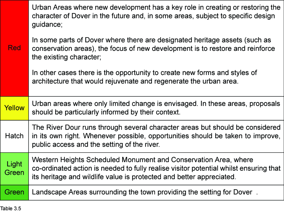
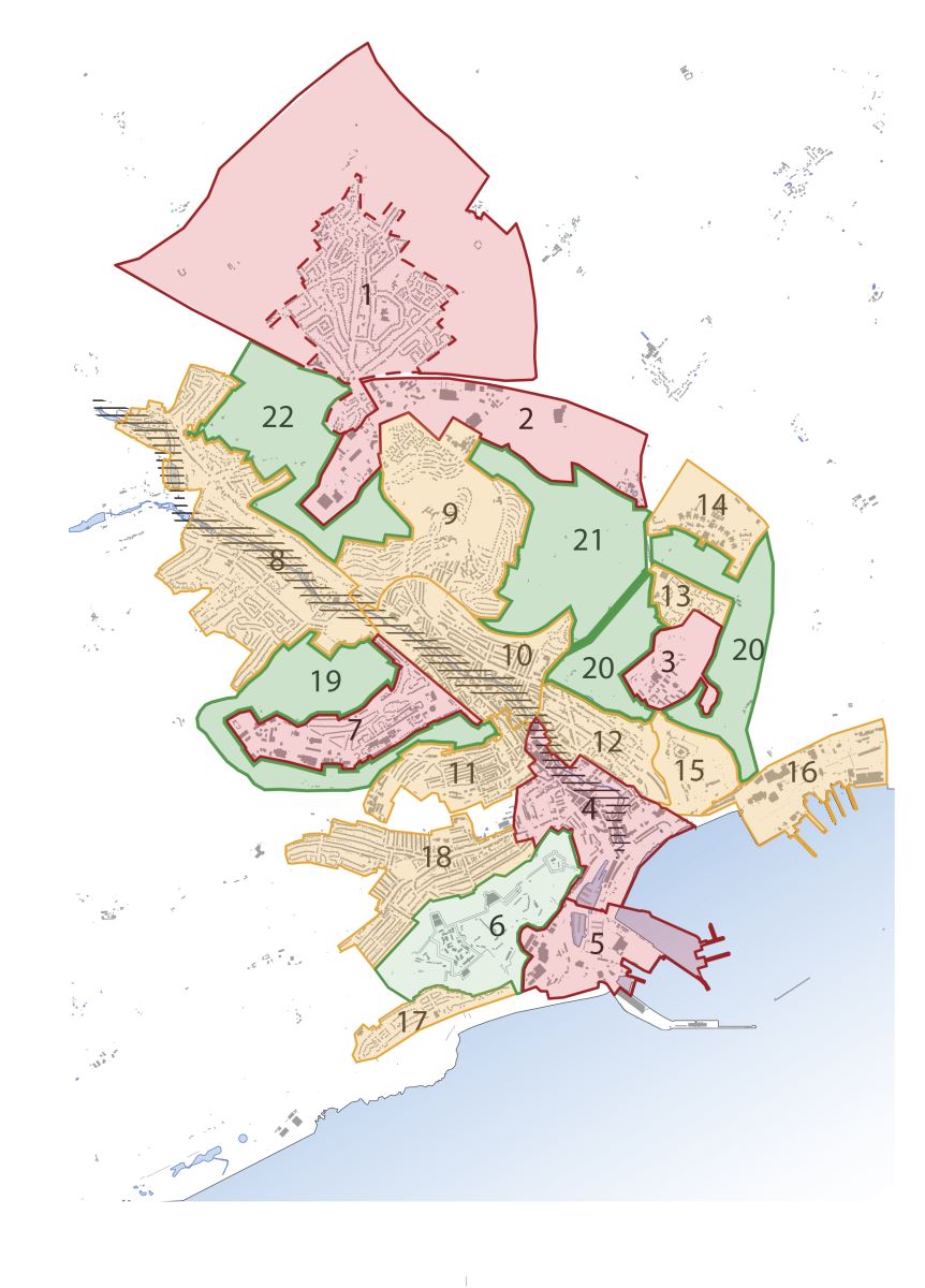
.jpg)
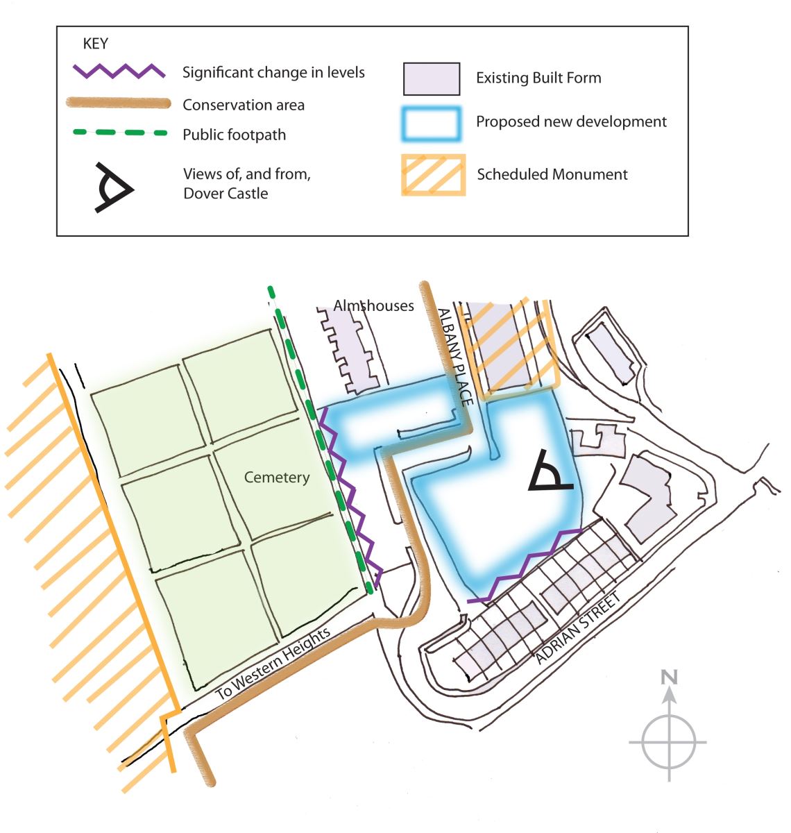
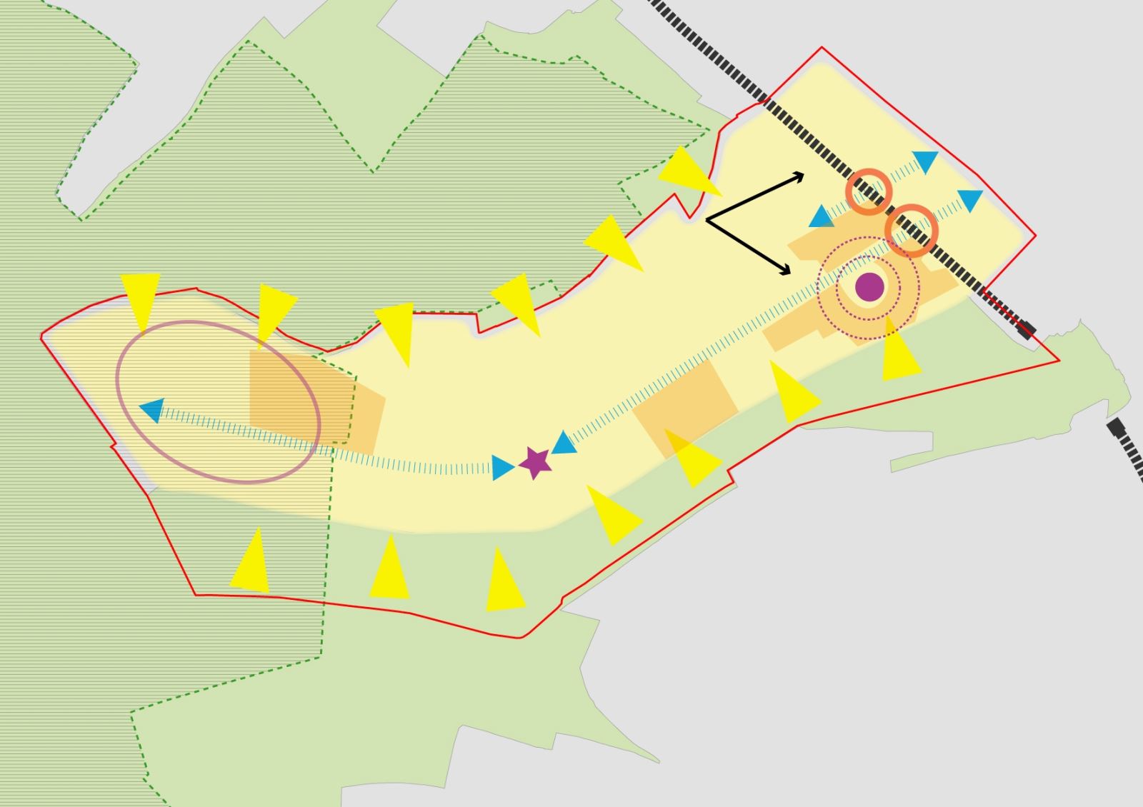
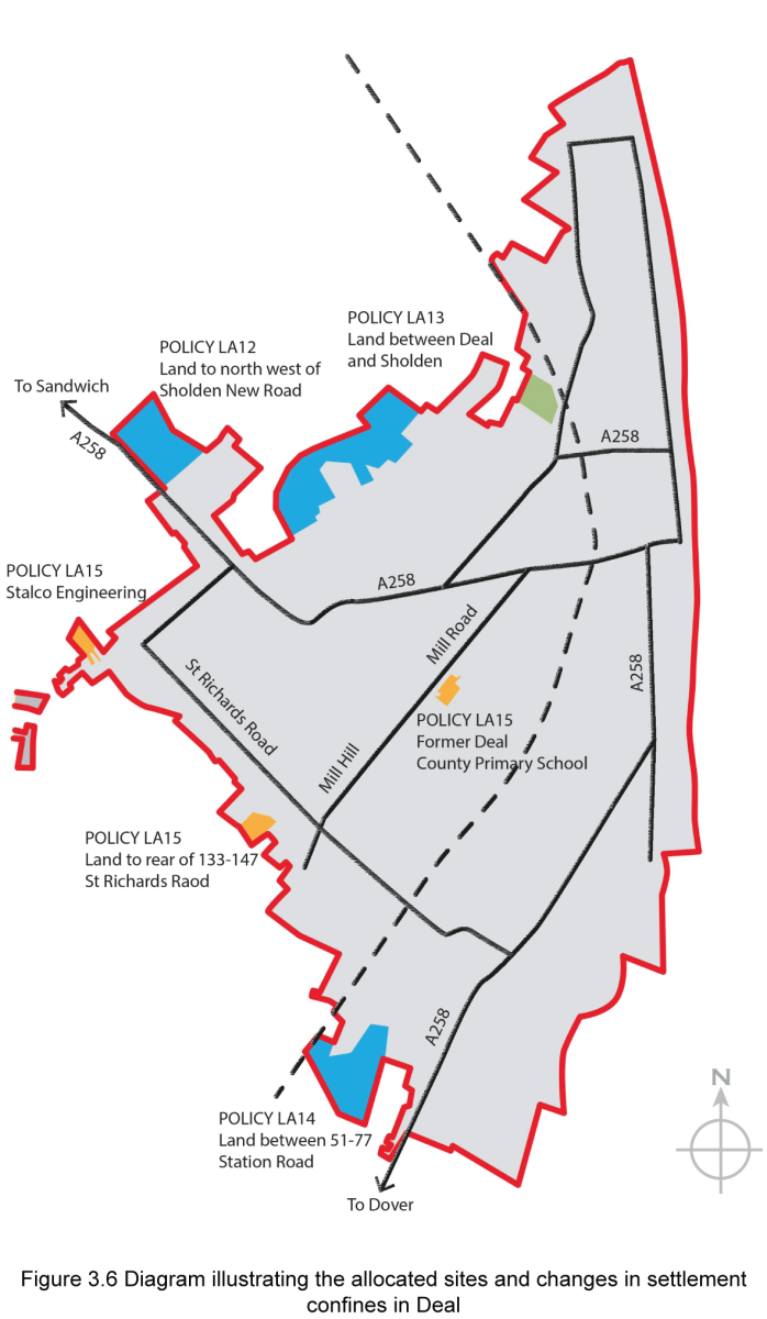
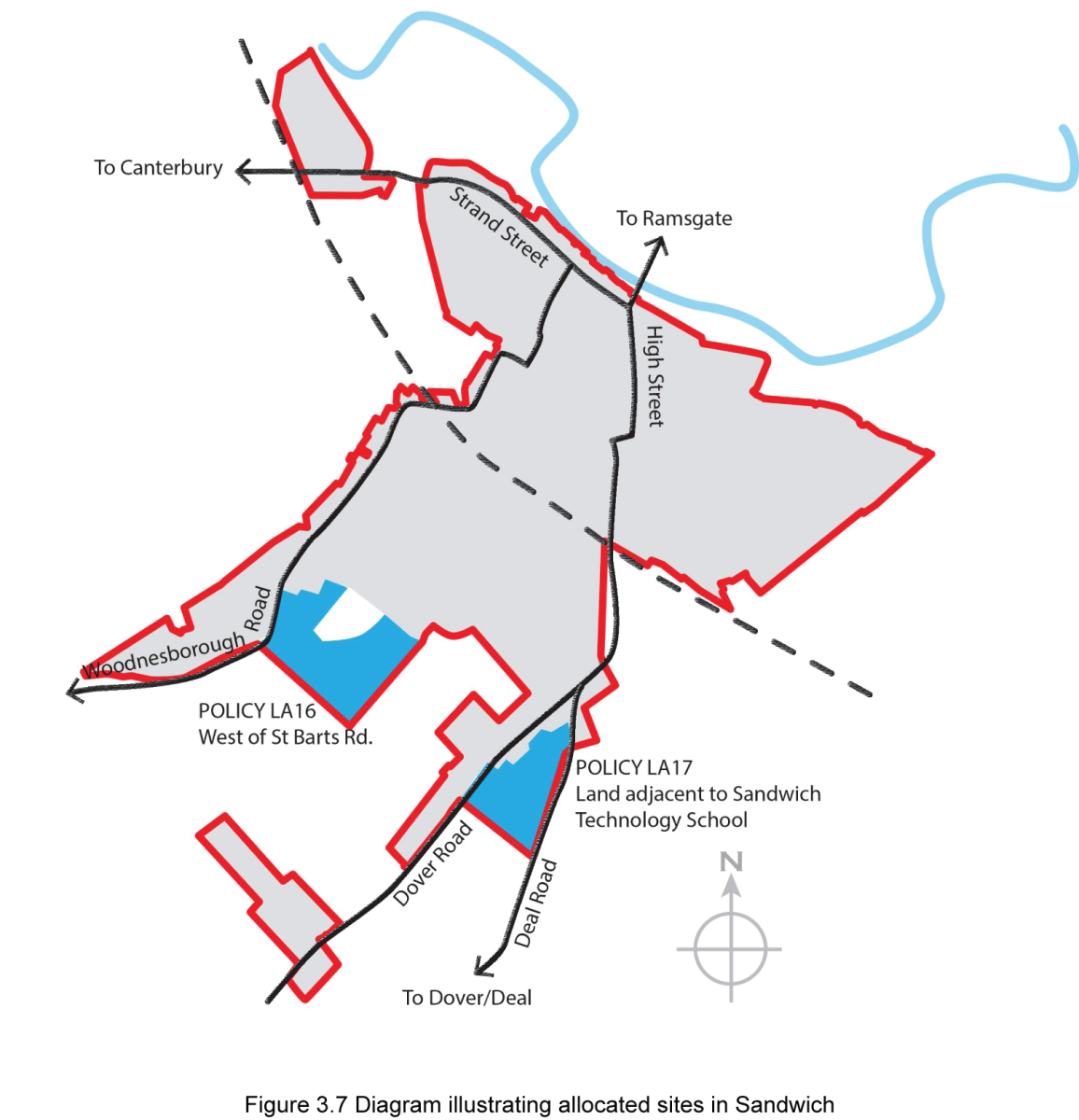
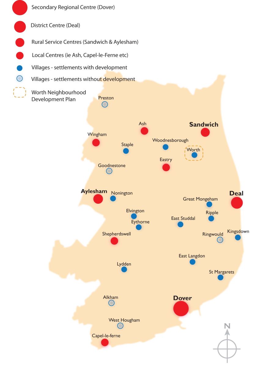

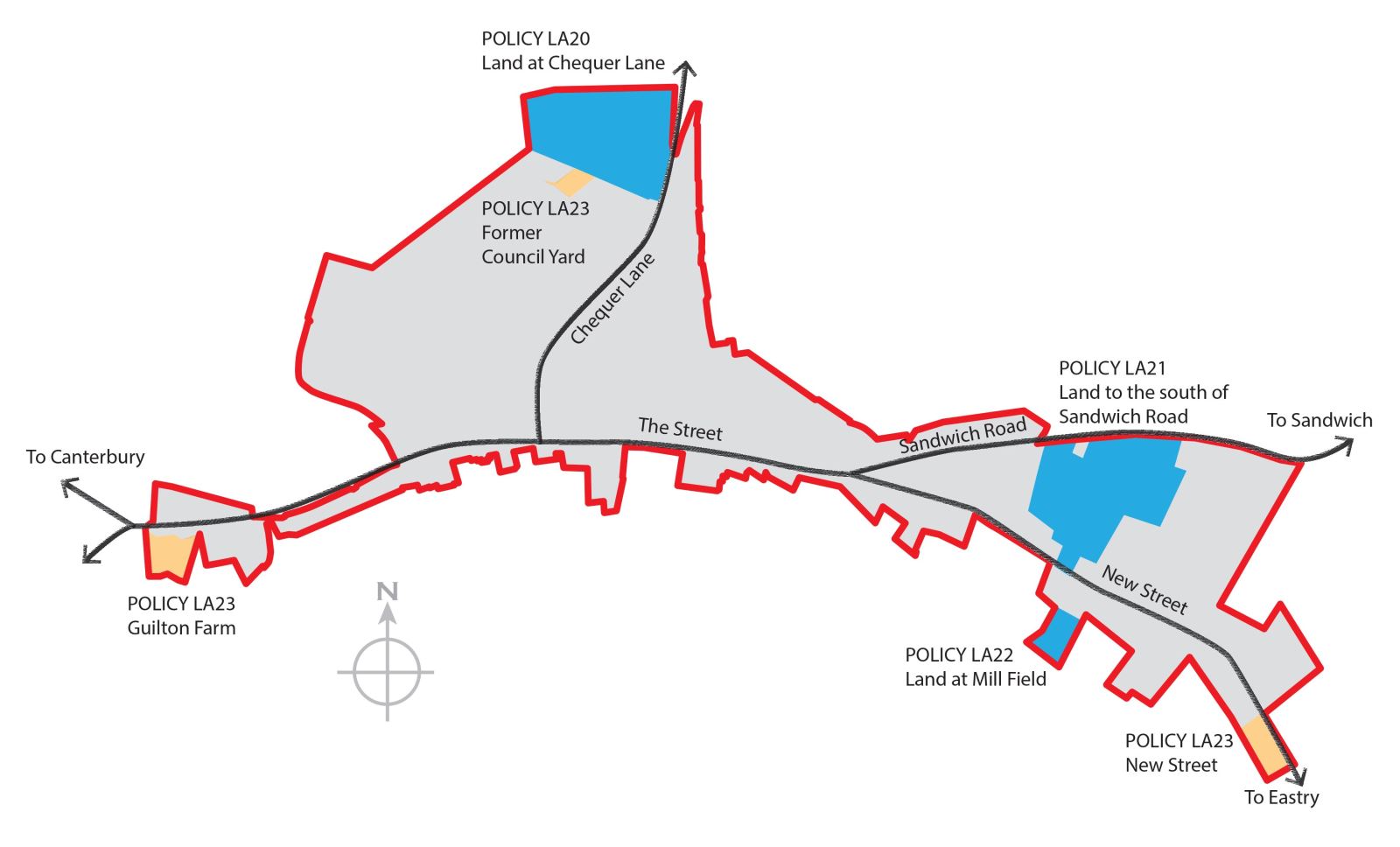
.jpg)