Annex 1 Development Management Guidance and Policy
1.1
Proposals for development will be judged against all relevant policies in the Development Plan. The Development Plan consists of the District Local Plan, which currently consists of this Plan, the Core Strategy and saved elements of the 2002 Local Plan, and the Kent Minerals and Waste Local Plan produced by Kent County Council. In addition all Local Plans must take full account of national policies set out in the National Planning Policy Framework (NPPF), together with requirements of planning legislation and Planning Practice
Guidance.
New Comparison Provision
1.2
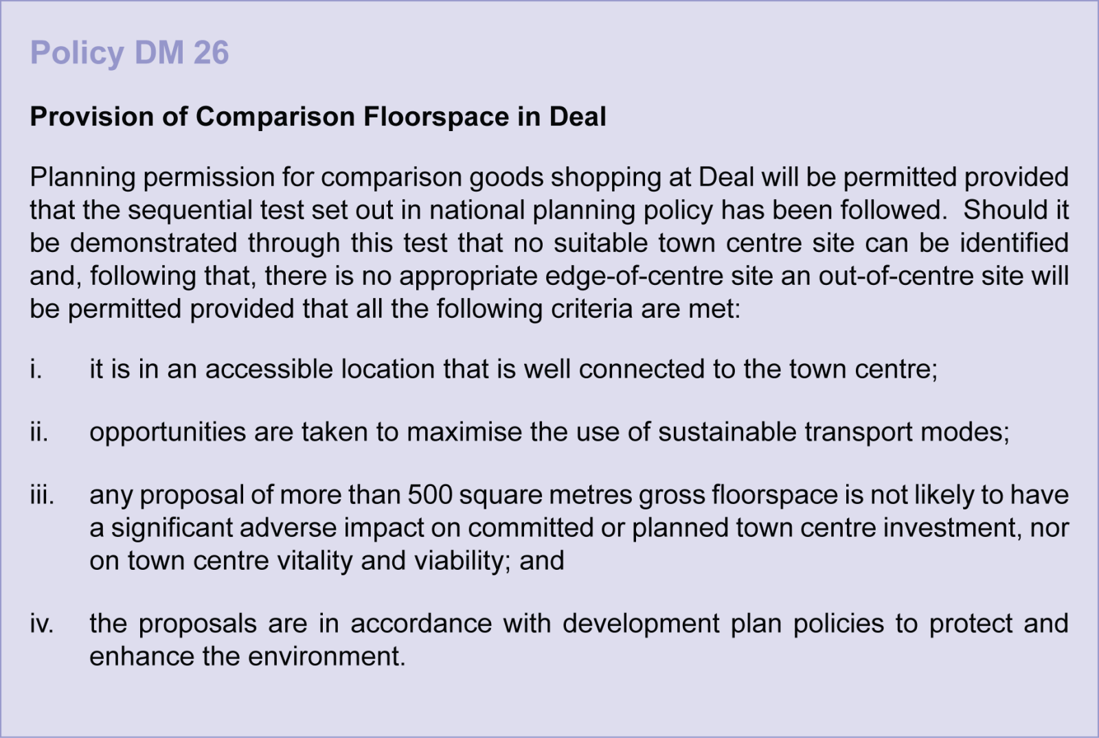
As outlined in Chapter 2 (Overarching Policies) the Dover District Retail Update (2012) has identified a need for comparison floorspace in Deal. This amounts to a requirement for 7,700 square metres of gross floorspace by 2026. The NPPF and PPG recognises that town centres are at the heart of communities and that Plans should allocate suitable site(s) for main town centre uses to meet the scale and type of retail development that is needed. If sufficient town centre or edge of centre sites cannot be identified or viable town centre sites are not available, the Council should set policies for meeting the identified need in other accessible locations that are well connected to the town centre. For further details please see Table 2.1 and paragraphs 2.10 to 2.17.
1.3
The Retail Update identified that proposals for comparison floorspace over 500 square metres of gross floorspace should be accompanied by an impact assessment.
Guidance on Heritage Assets
1.4
The primary purpose of the Heritage Strategy is to identify, group and understand the value of the District’s heritage assets. The Heritage Strategy is available on the Council's website www.dover.gov.uk/landallocations. The Strategy, however, considers a wide range of issues beyond the scope of this Local Plan, this section of the Annex provides additional support to the Heritage Strategy through:
-
Guidance to help make planning decisions; and
-
Promoting a better understanding of heritage assets in the District
Guidance for Planning Applications
1.5
The NPPF sets out the Government's policy stance to be considered as part of any planning application and this is considered to be sufficient not to warrant specific policy for
heritage assets.
1.6
The starting point in the NPPF is that it is important to understand the value of heritage assets as part of any planning application, whether these are on or close to the site. The NPPF states that Local Planning Authorities should require applicants to describe the significance of any assets affected, including any contribution made by its setting. This
assessment would be provided in Heritage Statements that are an integral part of the planning application, describing the significance of any heritage assets affected. Heritage Statements that do not address the above can result in delays to the assessment and determination of planning applications.
1.7
To assist developers with this requirement, the Heritage Strategy has provided a wealth of information that should be referred to. It has identified and provided a commentary on,
thirteen broad themes to identify the numerous individual or groups of assets. Some of these themes have also been broken down into sub-themes. The Heritage Strategy has also assessed the significance of the themes to help applicants meet the requirement in the NPPF. The table below summarises the significance of the thirteen themes.
| Theme | Significance |
| Coastal Process and Landscapes | Outstanding |
| Coastal Ports | Outstanding |
| Invasion and Defence | Moderate to Outstanding |
| Communications | Considerable |
| Maritime | Outstanding |
| Church | Outstanding |
| Country Houses and Estates | Considerable |
| Settlement | Outstanding |
| Agriculture and Farmsteads | Moderate to Outstanding |
| Industry | Moderate |
| Archaeology | Outstanding |
| Built Heritage | Outstanding |
| Conservation Areas | Outstanding |
1.8
To help improve the quality of Heritage Statements the Heritage Strategy has also identified a ‘Themes Assessment’ check list to assist in the assessment.
1.9
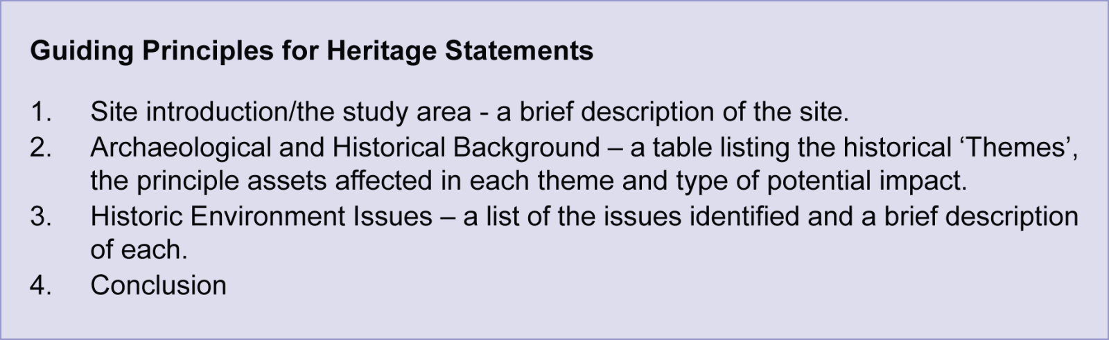
Furthermore, the Heritage Strategy has also provided guiding principles for Heritage Statements for larger schemes. These have been set out in four case studies (Discovery Park, Sandwich; North Deal; Farthingloe, Dover; and Fort Burgoyne & Connaught Barracks), and follow a simple format:
1.10
For smaller scale proposals, additional advice on producing Heritage Statements is available on the Council's web site. The knowledge base will also be improved over time with the Conservation Area Character Appraisals and Local Lists.
1.11
Chapter 6 of the Heritage Strategy considers the opportunities for heritage assets in the District, in particular how these can add value to new developments and how they could be used to improve the offer for tourism.
Promoting better understanding of Heritage Assets
1.12
A key component of the Heritage Strategy is to promote a greater understanding by the Local Authority, landowners and local people of the heritage assets in the District. One of the best ways of raising appreciation of the historic environment, developing a sense of place for communities and helping to sustain and realise the benefits of heritage assets is to engage and encourage local people and groups to take a leading role in heritage activities.
1.13
Whilst many actions are outside the remit of this Plan, the Heritage Strategy has identified two areas where the involvement of local groups, would be of benefit. These are
Conservation Area Character Appraisals and the production of a Local List of Heritage Assets.
1.14
It is envisaged that the assessment work would be completed by the local community with agreement by the District Council. To ensure that the assessments follow the same methodology, the District Council will produce guidance notes. These will be based on best practice, such as that produced by English Heritage.
1.15
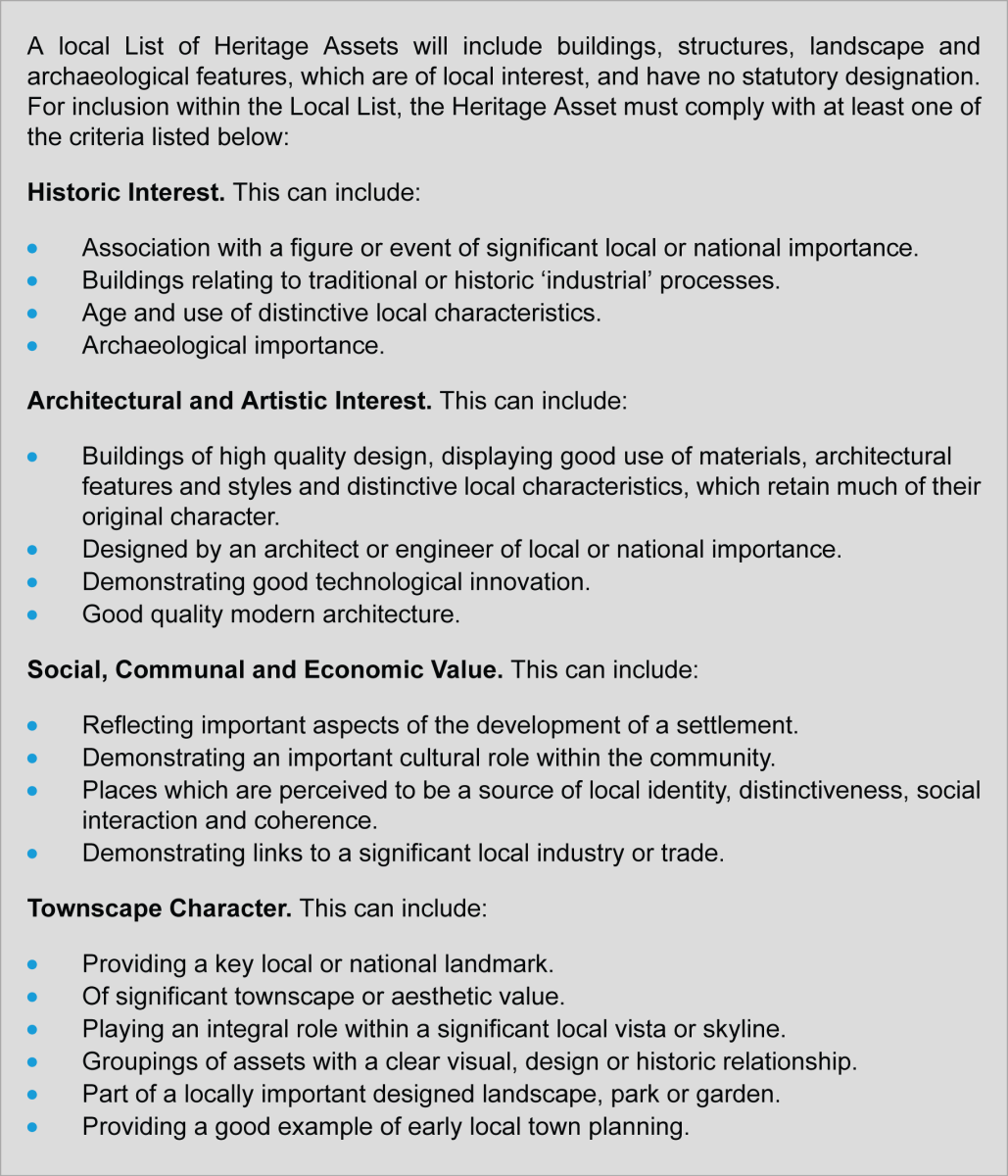
The NPPF states that non-designated heritage assets should be taken account of when considering planning applications. A Local List would enable the importance of undesignated local heritage assets to be taken into account in the processing of any planning applications, which have an impact on them and their setting.
1.16
The criteria for identifying Heritage Assets for a Local List are as follows:
Guidance on Coastal Change Management Areas
1.17

With regard to future planning applications and assessment against the CCMAs it is not proposed to include a policy in this Plan as the NPPF and the accompanying Practice Guide sets out the planning considerations for Coastal Change Management Areas (CCMA).
1.18
Paragraphs 106 to 108 in the NPPF and, in particular, the Planning Practice Guidance provide clear guidance as to what is, and what is not, suitable for new development and this will be the initial policy stance of the District. The Planning Policy Guidance is summarised below:
-
Essential infrastructure may be permitted in a CCMA provided there are clear plans to manage the impacts of coastal change on it, and it will not have an adverse impact on rates of coastal change;
-
MoD installations that require a coastal location can be permitted within a CCMA provided there are clear plans to manage the impacts of coastal change;
-
For all other development, within short-term risk areas (i.e. 20 years time horizon) only a limited range of types of development directly linked to the coastal strip such as beach huts, café/tea rooms, car parks and holiday short-let caravans and camping, might be permitted;
-
Within medium to long term risk areas (i.e. 50 to 100 years time horizon) a wider range of time-limited development might be permitted such as hotels, shops, offices or leisure activities requiring a coastal location and providing substantial economic and social benefit;
-
Permanent new residential development would not be appropriate.
1.19
Where extensions and alterations permitted under the General Permitted Development Order are likely to result in an increase in the scale of property and number of occupants at risk from coastal change in the short-term (i.e. next 20 years), the District Council will consider whether to make greater use of an Article 4 Direction under the Town and Country Planning (General Development Procedure) Order 1995 to require planning permission to be sought.
1.20
Development proposals that fall within the Kent Downs Areas of Outstanding Natural Beauty and Heritage Coast would also be restricted by those designations so the above examples may not be acceptable for reasons other than vulnerability to coastal erosion.
Thanet Coast and Sandwich Bay SPA and Ramsar Mitigation Strategy
1.21
It is a requirement of the EU ‘Habitats Directive’ 1992 (hereafter referred to as the Habitats Directive) (1) and the Conservation of Habitats and Species Regulations 2010 that
‘land use plans’ (including local authority Local Plans) are subject to an ‘Appropriate Assessment’ (AA) if it is likely that they will lead to significant adverse effects on a Natura 2000 site (Special Areas of Conservation (SACs), and Special Protection Areas (SPAs)). As a matter of UK Government policy Ramsar sites (2), candidate Special Areas of
Conservation (cSAC) and proposed Special Protection Areas (pSPA) are given equivalent status. These protected sites are collectively referred to as ‘European sites’ - see Kent Landscape Information System (KLIS) website for further information.
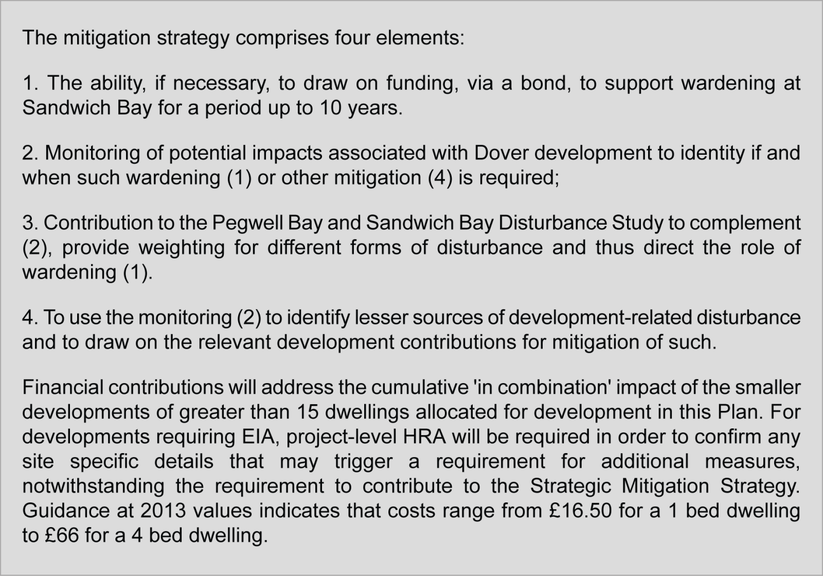
1.22
The Habitats Directive applies the precautionary principle to protected areas; plans and projects can only be permitted having ascertained that there will be no adverse effect on the integrity of the site(s) in question. The HRA of this Plan concluded that, due to the existence of the Thanet Coast and Sandwich Bay SPA and Ramsar Mitigation Strategy and the requirement for all new dwellings to contribute to that Strategy to deliver enhanced management of the SPA, the scale of development set out in this Plan will not lead to an adverse effect on the integrity of Thanet Coast & Sandwich Bay SPA, either alone or in combination with other projects and plans.
1.23
Full details of the Mitigation Strategy are contained within 'Thanet Coast and Sandwich Bay SPA and Ramsar Mitigation Strategy' and is available on the Council's website at www.dover.gov.uk
1.24
The purpose is to avoid potential impacts brought about by demographic changes, rather than ameliorate pre-existing impacts. However, a strategy that may have coincidental effects on existing impacts would produce an overall benefit. Wardening, for instance, should, by its very nature, reduce existing as well as new impacts.
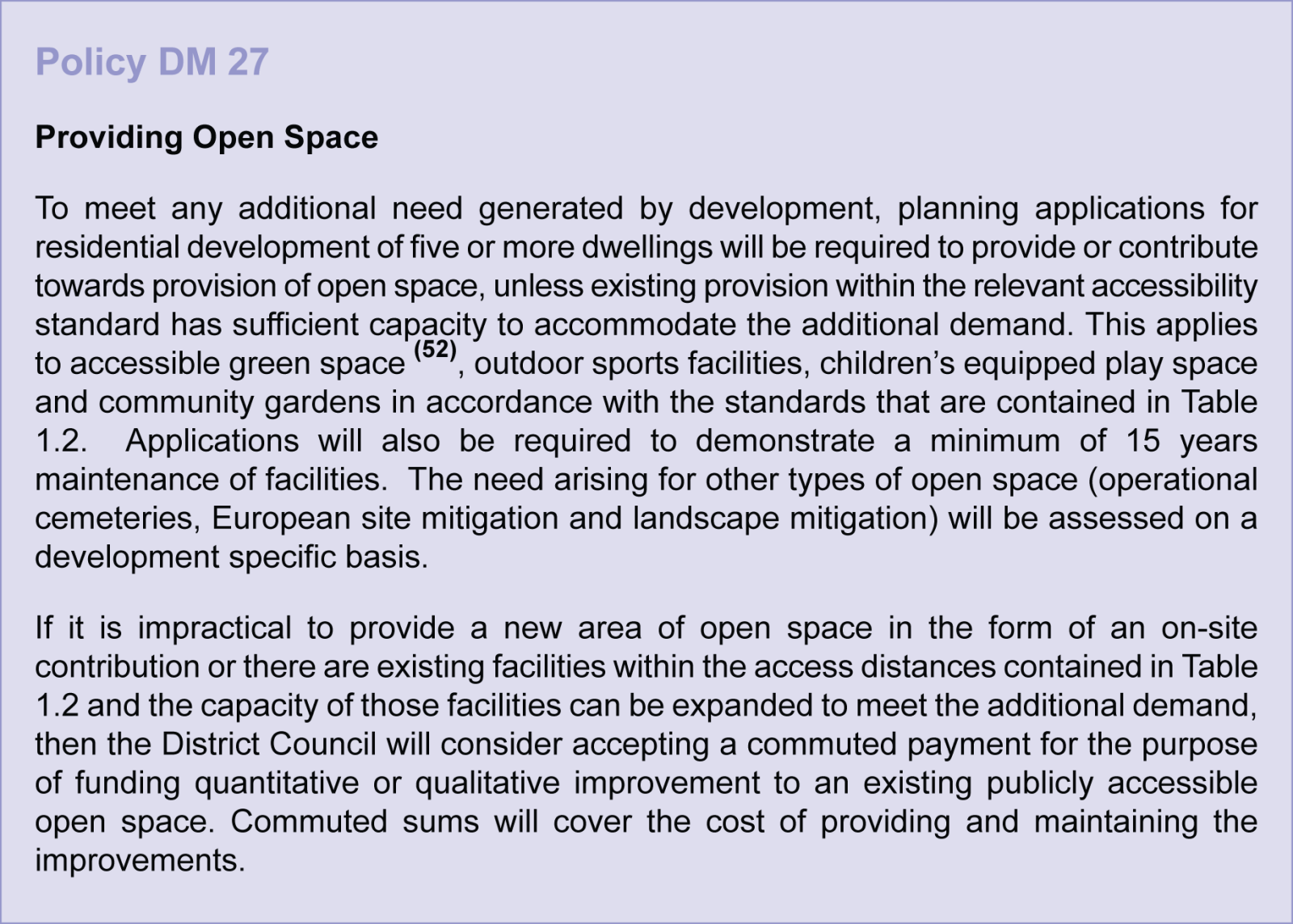
Open Space and Play Space Standards Policy
1.25
Access to high quality open spaces and opportunities for sport and recreation provides a vital contribution to community health and well-being. Growth expected in the District will increase the pressure on existing open space resources; therefore it is important to plan positively to meet the additional demand by enhancing existing facilities or creating new open spaces and securing their maintenance in the long term. The NPPF states that local planning authorities should base their policies for open spaces on robust and up-to-date assessments of local needs. Furthermore, these assessments should identify specific needs and quantitative or qualitative deficits or surpluses of open space, sports and recreational facilities in the local area.
1.26
Open Space Standards have been produced to help evaluate any additional need arising from new development. Expected levels of quantity, quality and accessibility for the various categories of open space are defined within the standards. The standards have been derived using information gained from a number of sources, including recent comprehensive audits of outdoor sports facilities and equipped children’s play areas. Projects designed to address any identified deficits and spare capacity will be set out in supporting strategies. Supporting documents, such as the ‘Review of Play Area Provision 2012-2026’, are available on the Council's website.
The standards apply to four categories of open space:
-
Accessible green space – parks and gardens, amenity open space, green corridors, village greens, informal kick-about areas, informal playable space and closedchurchyards;
-
Outdoor sports facilities – dedicated sport facilities that are suitable for competitive matches and formal training activity;
-
Children’s play space – equipped play space, multi-use games areas and skate parks; and
-
Community gardens and allotments.
1.27
The total requirement for these categories of open space is 3.66 hectares per 1,000 residents. Details of the standards are provided in Table 1.2, including the minimum acceptable travelling time from new developments. Topographical factors must be taken into account when considering accessibility; the distance from a site to the nearest open space facility should be measured along pedestrian routes.
| Open Space Type | Quantitative Standard | Accesibility Standard (1) | Quality Standard | Notes |
|
Accessible green
space
|
2.22 ha per
1,000
population
|
At least one accessible green space of minimum size 0.4ha within 300m. At least one green space 2ha within 15 minute walking time/1000m | Green Flag guidance at strategic sites. Qualitative improvement priorities at non-strategic sites discussed in the forthcoming refreshed Parks and Open Spaces Startegy | Green Flag status is held by one site in the District: the semi-natural space at Samphire Hoe. The long-term aspiration is to gainGreen Flags for strategic parks; the adopted Parks & Open Spaces Strategy sets out action plans to achieve this |
| Outdoor sports facilities |
1.17 ha of
natural grass playing pitches pwe 1,000 population
|
Three sub-areas within the district have been defined on the basis of league structures (Dover, Deal and rural) | Sport England design and cost guidance quality standards of relevant National Governing Bodies of Sport | Requirements for artificial grass pitches, tennis courts, bowling greens, athletics tracks and netball courts are detailed in the adopted Playing Pitch and Outdoor Sport Strategy |
|
Children's equipped
play space
|
0.06 ha per
1,000
population
|
Local play
space within 600m and/or strategic play space 1,000m. At least one equipped play space in each settlement of village level or above
|
Play England
Guidance, such as 'Design for Play.' Fields in Trust Guidance such as ' Planning and Design for Outdoor Sport and Play.'
|
Provision of 'Playable' accessible green spave replaces the previous requirement for Local Areas of Play. Requirements for multi-use games areas and skate parks are detailed in the adopted Playing Pitch and Outdoor Sport Strategy |
|
Allotments/Community
Gardens
|
0.21 ha per
1,000
population
|
At least one site within 15minute walking time or 1,000m | Not applicable |
(1) Accessibility standards are only applicable to settlements of village level or above, as defined in the Core Strategy settlement hierarchy (CP1). In hamlets long term support for open space facilities is more difficult to achieve, and in any case residents usually have ready access to public rights of way and the wider countryside. In addition, the requirement for a green space at least 2ha in size within 15 minute walking time/1,000m is only applicable to settlements of rural service centre level or above.
1.28
Requirements for some categories of open space cannot be expressed as district wide standards, therefore they will be assessed on a development specific basis. For example, operational cemeteries have been excluded from the standards, even though the Core Strategy recognises that additional cemetery provision will be required to serve the
Dover urban area. Operational churchyards exist throughout the District, some of which could be extended. However, new cemetery provision derived through planning means should be suitable for all and acceptable to all religions (50). Large developments could possibly meet this need on site, but it is not realistic to expect that new facilities be createdwithin walking distance of all urban residents and therefore an accessibility standard is not defined. A survey carried out in 2010 (51) indicated that Dover District residents are willing
to travel further to access cemeteries than other green infrastructure types.
(50) A site assessment study for the Dover Town's new cemetery, Dover District Council, 2010
(51) Proposed Standards for Open Space Provision, Dover District Council, 2011
1.29
In ‘Nature Nearby: Accessible Natural Greenspace’ (Natural England, March 2010), four levels of ‘naturalness’ category are given. Some of the sites discussed are subject to the local open space standards, the rest are designated for nature conservation either as European sites for conservation or Biodiversity Action Plan (BAP) Habitats. The Natural Environment and Rural Communities Act, 2006, put responsibilities on local planning authorities to maintain or enhance biodiversity. While broad targets are established through the BAP, enhancements deriving from development must be dictated by site-specific conditions and may not be expressed as a quantitative standard unless it incorporates
biodiversity targets. Additionally there may be a need to reduce impact on the landscape. For these reasons, no local standards are set for accessible natural/semi-natural green
space.
(52)The types of open space categorised as accessible greenspace are listed in paragraph 1.26. Additional need for accessible green space that arises from new development may be met by provision of a combination of suitable open space types. Clearly, some types cannot be created within new developments, for example closed churchyards, however off-site contributions may be used to increase the capacity of suitably located of any type of accessible greenspace
1.30
The additional need arising from residential developments will be calculated using estimated occupancy rates given in the KCC paper’ Demographic Forecasts Dover District
Council, April 2010’, or a subsequent document. A worked example is presented in Tables 1.3 and 1.4, which calculates the open space needs arising from a hypothetical development of 100 units built to the Core Strategy housing mix. For very large applications, more detailed population modelling may be necessary to obtain predicted age structure, in order to utilise the Sport England Playing Pitch Model.
| Dwelling Type | Occupancy Rate | Number of Units |
Number of
Occupants
|
| 1 bed flats | 1.247 | 15 | 19 |
| 2 bed houses | 2.112 | 35 | 74 |
| 3 bed houses | 2.621 | 40 | 105 |
| 4 bed houses | 3.245 | 10 | 32 |
| Total | 230 |
| Open Space Type |
Qualitative standard (Ha per thousand population)
|
Number of New
Residents
|
Open Space
Requirement
|
| Accessible Green Space | 2.22 | 230 | 0.51 |
| Outdoor Sports Facilities | 1.17 | 230 | 0.27 |
| Childrens Equipped Play Space | 0.06 | 230 | 0.01 |
| Allotments/ Community Gardens | 0.21 | 230 | 0.05 |
| Total | 0.84 |
1.31
These open space needs may be met by new provision on-site. Alternatively, the standards will be applied to determine whether facilities already exist within an acceptable distance and whether sufficient capacity exists in them to accommodate the additional demand. In most cases it will be possible to provide at least some of the accessible green
space within developments especially where fifteen or more houses are proposed. If the accessible green space is designed to be playable this would meet the need previously
catered for by Local Areas for Play. Spare capacities and deficiencies of outdoor sports facilities within the district’s three subareas are discussed in the adopted 'Playing Pitch and Outdoor Sports Facilities Strategy’, which includes an analysis of provision based on the Sport England Playing Pitch Model (PPM) that utilises supply and demand data. Demand for children’s equipped play areas is presumed to exist in all urban areas(53), information on supply is presented in ‘Review of Play Area Provision 2012-2026'. Open space projects are being delivered all the time, so it will be necessary to check if provision local to the development has changed since the most recent strategy was published.
(53) See discussion at paragraph 8.18 of Open Space Policy and Standards consultation (PS03)
1.32
Out-of-town commercial developments on allocated sites are covered by site-specific policies that consider issues such as the impact on nearby natural and semi-natural green infrastructure and appropriate provision of green corridors and landscaping. For example Policy LA2 applies to Phases II and III of White Cliffs Business Park in Whitfield. It sets out
requirements for improvements to the North Downs Way, structural landscaping and buffer zones. If unallocated sites come forward for commercial development the need for green infrastructure will be assessed on a site-specific basis.
1.33
Commercial developments within settlement confines may be capable of providing green infrastructure or public realm facilities to support increased footfall caused by the scheme. Examples of suitable projects are outlined in the Public Realm Strategy (October 2006). A commercial development that has a demonstrable local impact on the green infrastructure network should contribute to a project to mitigate those impacts.
1.34
Historically Dover District Council has secured off-site contributions via S106 agreements, including the cost of maintaining new facilities for fifteen years. This will continue
at least until a locally determined Community Infrastructure Levy (CIL) is introduced. The Council is preparing to introduce CIL to the District, and may choose to secure funding for open space provision via that route in the future. In the meantime, the 2010 CIL regulations have introduced restrictions to the way in which S106 agreements may be used. Planning obligations (such as off-site contributions) may only be secured if they are:
(a) necessary to make the development acceptable in planning terms;
(b) directly related to the development; and
(c) fairly and reasonably related in scale and kind to the development.
1.35
In addition, off-site contributions may only service the additional need that arises from the new development; they cannot be used to put right existing deficiencies.
1.36
Appropriate off site contributions will be calculated by working out the proportion of a complete facility required to meet the additional need. For example the need of 0.27 ha
calculated in Table 1.4 equates to 23% of a standard senior football pitch(54), therefore 23% of the cost of creating such a facility would be an appropriate contribution. Costing guidance is provided by Sport England, for example in the document ‘Life Cycle Costings, Natural Turf Pitches’. Due to the limit on pooling S106 payments to no more than five per project, contributions are unlikely to be sought where the need created forms less than one fifth of a facility. Allocation of any off-site monetary contributions to projects will be guided by the accessibility standards, to ensure the facilities provided are directly related to the development. The detailed arrangements for any on or off-site provision will depend on the particular local conditions and issues, which may vary from site to site. In some cases improved access arrangements to an existing facility may be an appropriate use of off-site contributions.
(54) According to 'Comparative sizes of Sports Pitches and Counts' a senior football pitch (including run offs) measures
1.2Ha https://www.sportengland.ord/media/30685/comparative-sizes-checklist-April-2011.Pdf
1.37
This policy will support the implementation of two open space related policies in the Dover District Core Strategy (adopted 2010). Policy DM25 protects existing open space, while CP7 protects the wider Green Infrastructure Network. The standards will help to protect and enhance the publicly accessible open space component of existing green infrastructure by ensuring that proper consideration is given to needs arising from development. Provision of appropriate open space facilities has a valuable role in protecting the wider Green Infrastructure Network by significantly deflecting recreational pressures away from protected natural and semi-natural elements. Application of the standards will also provide a clearly defined approach for determining whether public open space provision is deficient in the vicinity of a proposed development on protected open space.
Schedule of Policies
1.38
The table below lists, by policy issue, which of the saved Local Plan Policies are to be replaced by policies in the Land Allocations Local Plan.
| Policy Issue |
Land Allocations
Local Plan Policy
|
Saved Dover District
Local Plan Policy
(2002) replaced
|
|
Development of White Cliffs Business Park, Dover
|
LA2 | LE3 |
|
Children's Play Space provision in
developments of 15 or more dwellings
|
DM27 | OS2 |
|
Provision of open space needs fromnew
development
|
DM27 | OS3 |
| Eastry Hospital | LA29 | AS11 |
1.39
The following table lists the saved Local Plan Policies (2002) that are to be deleted and not replaced.
| Policy Issue |
Saved
Dover
District
Local Plan
(2002)
Policy to be
deleted
|
Explanation for deletion |
| Industrial and business land allocations | LE2 |
DM2 in the Core Strategy has replaced this policy. Individual allocations are identified in the Land Allocations Local Plan.
|
| Minter's Yard, Deal | LE4 | The site has planning permission and is under construction |
| Marlborough Road, Deal | LE6 |
The Retail and Employment Update (2012) has indicated that this allocation is no longer required
|
| Expansion at Pfizer | LE9 |
The policy was specific to Pfizer. The
company has now sold the site and the site is now an Enterprise Zone and subject to a LDO.
|
| Safeguarding primary and secondary retail frontages in towns | LE12 | Policy DM22 in the Core Strategy provides safeguarding for retail frontages. LE12 is not necessary. |
| Dover Castle Officer's Mess | LE25 |
Site specific policy not considered
necessary as this site could come forward under Development Management policies.
|
| Land allocated for housing | HS2 |
The sites identified in this policy have either been developed or saved.
|
| Land south of Northwall Road Deal | HS6 |
Site is within Flood Risk Zone 3 and within the Rapid Inundation Zone (RIZ). Part of the site has been developed.
|
| New convenience provision at Dover | SP3 |
This policy is no longer necessary as the issues are covered in the NPPF.
|
| New comparison at West Street, Deal | SP8 | The site has been developed for other uses. |
| Betteshanger Spoil Tip | AS2 |
This has been completed (Fowlmead
Country Park).
|
| Royal Marines School of Music, North Barracks, Deal | AS3 | The site is under construction. |
|
Army Careers' Information
Office, Townwall Street
|
AS5 |
The site allocation does not conform to the town centre sequential test as set out in the NPPF.
|
| Old Park Barracks, Dover | AS8 | Site has extant planning permission |
| Church Farm, East Langdon | AS10 | Site has been developed. |
| Boyes Lane Goodnestone | AS12 | Site has been developed. |
| Ramsgate Road, Sandwich | AS14 |
Sites have planning permission and/or have been developed. Minerals and Waste Policies apply.
|
| Sandwich Industrial Estate | AS15 | Application has been implemented |
|
Snowdown Colliery Pithead
and Sidings
|
AS16 | Site is not viable |
| Snowdown Colliery Spoil Tip | AS17 | Site is not viable |